Category Archives: Uncategorized

Google + NASA: What’s in store?

It’s announcement day today in the Google Earth ecosphere. Announcement number one we were expecting, though the precise nature of its content we were not: A formal relationship between NASA and Google “to work together on a variety of challenging technical problems ranging from large-scale data management and massively distributed computing, to human-computer interfaces.” You can read the rest of the press release here. (Here’s another, on NASA.gov)

No mention of iEarth, though it is very much part of what is envisaged — it’s just that the agreement encompasses so much more, including “Real-time weather visualization and forecasting, high-resolution 3- D maps of the moon and Mars, real-time tracking of the International Space Station and the space shuttle”. (Excellent news about Mars and the Moon — I was certainly hoping for that.)

The challenge:

“NASA has collected and processed more information about our planet and universe than any other entity in the history of humanity,” said Chris C. Kemp, director of strategic business development at Ames. “Even though this information was collected for the benefit of everyone, and much is in the public domain, the vast majority of this information is scattered and difficult for non-experts to access and to understand.

And since Google’s mission is to “organize the world’s information”, this is exactly the kind of challenge it excels at; namely “technical problems ranging from large-scale data management and massively distributed computing, to human-computer interfaces.”

A NASA World Wind developer’s blog, The Earth is Square, broke the news, though its take is that NASA World Wind already does most of what the agreement sets out to do. Indeed, current Mars and Moon imagery is available in NASA World wind, and some other features, like live positions of spacecraft, are available now as a plugin in both Google Earth and World Wind. But that leaves out terrabytes upon terrabytes of data that is just waiting to be processed and made usable. And that’s not something an open-source 3D viewer project is going to crack anytime soon.

Ultimately, this announcement is not about the client, but about the content, and I for one am very excited about the prospects. The Earth is Square is right, albeit graceless, when it writes, “But let Google spend its millions.. they do the hard work and because the data has to be in the public domain.. it will be in World Wind in no time.” Indeed, and users will then get to decide if they want to view the data on a souped-up atlas with social software skills and high resolution imagery as context, or in a realistic-looking, open-source virtual globe. There’s room for both.

Google Earth data update: Edinburgh, Canary Islands, Indiana, Delaware, Somalia…

Looks like Christmas came early: Not content with merely releasing an update to the application this weekend, the Google Earth team also just went ahead with an update to the imagery and the terrain: From this post on Google Earth Community:

Terrain update:

In the first time in quite a while, we’ve updated terrain with a high resolution (3m) terrain inset for Mt. Saint Helens, Washington.

Imagery updates:

  • Digital Globe updates all over the globe with the most notable being large content additions in Somalia and Australia
  • Updated US states: Indiana and Delaware
  • Miscellaneous high res cities and counties in North America: Monterey Bay, CA; Yakima County, WA; Summerland, Canada; Greater East Wenatchee, WA; Polk County, IA; Warren County IA; and Bay County, FL
  • Small high-res updates in the UK (Swansea, Edinburgh, Doncaster, Gwent) and expanded London coverage
  • High-res update in Bremerhaven, Germany.
  • Newer imagery for Lanzarote (Canary Islands)
  • Google Earth Blog-supplied XPrizeCup flyover and the Sanford, NC airport
  • Cabo San Lucas, Mexico
  • Foo Camp @ O’Reilly Headquarters in Sebastapol, CA

There’s something for everyone: Frank Taylor’s own flyover imagery from the XPrize Cup is included, while the good residents of the Canary Islands get updated and uncensored imagery (they weren’t happy earlier this year when their data got older and censored). And the fantastic city of Edinburgh, which was a murky greenish brown blur in Google Earth when I visited last week, is now in glorious high resolution.

But perhaps my favorite updates are all the obscure, low-population density places that Digital Globe imagery brings into focus. It’s there that the surprises loom.

[Update 22:11 UTC: Wow — what a difference a 3m-resolution height mesh makes. Look at that plug dome on Mount Saint Helens:

mtsthelens.jpg

If you want to see what the “terrain quality” slider in the options does, Mount Saint Helens is a good place to try it. At the highest setting, the resolution is exquisite, but your frames per second will likely suffer. As more high resolution terrain becomes available, this will become a more and more important setting to get right.]

[Update 22:32: Some great new Digital Globe high res in the Hunza valley, in the Karakorum: Baltit Fort and the Ultar II glacier are now ready for their closeup.]

[Update 23:30: Apparently, this happened in the next-to-last update, but I only just noticed: Easter Island is now in high resolution, where you’ll find the best beach ever.]

Short news: iEarth Monday, AGU, patents

Short news:

  • The NASA-Google announcement is now set for Monday, Dec 18, 11:00 PST reports ZDNet, citing a NASA press release. It doesn’t get much sparser than this:

    WHAT: Media briefing announcing details of Space Act Agreement with Google, Inc.

    What is a Space Act Agreement? In the case of Google, it’s a private-public partnership. That’s the second one in a week involving Google Earth. BTW, everybody’s money is still on iEarth being announced.

  • Frank Taylor gives a great write-up of the special sessions on virtual globes at the American Geophysical Union’s (AGU) annual conference in San Francisco. Day 1, day 2 and day 3.
  • The patent tussle between Google and Skyline Software Systems appears to have taken another step. I got this in my newsreader today:

    Complaint, Counterclaims Filed In ‘Google Earth’ Patent Case

    BOSTON – In response to a first amended complaint (FAC) filed by Skyline Software Systems Inc. alleging patent infringement by Google Earth and related products, Keyhole Inc. and parent company Google Inc. (Google, collectively) have filed an answer alleging patent invalidity (Skyline Software Systems Inc. v. Keyhole Inc. and Google Inc., No. 06-10980 DPW, D. Mass.). Full story on lexis.com

    Nothing more is given away without us first ponying up some cash. Anybody with a Lexis subscription care to take a look? I’m interested, but not $25-dollars-interested, if you catch my drift. (Bloggers are cheap.)

  • A few days ago, a big phallic symbol discovered in Google Earth imagery of a British school’s roof caused a frisson online. It wasn’t worth a post, though one line in the story has now caught my attention:

    Google said: “If users spot something offensive we would consider having it removed.”

    I certainly hope that was a lie. Why go through all the trouble of standing up for freedom of speech, transparency, accuracy, impartiality, etc… when at the first sign of a lewd use of this freedom, it is given up. This is a slippery slope, it is.

  • A Norwegian site reports that local Norwegian company, Blom, has licensed its pictometry database to Microsoft — used for bird’s eye imagery. Blom’s own site shows it has plenty of images of Italy, so we can stop guessing as to where Microsoft got its Italy data from in the update last week. Also, there are some interesting details about the deal on Blom’s site, here:

    The agreement will give all Microsoft’s clients world wide the right to use Blom’s data for commercial purposes. The agreement will give Blom access to all Microsoft clients and their substantial sales force and network. Blom will receive an agreed portion of the revenue Microsoft will earn from their customers use of Blom’s database.

    Blom is the first Norwegian company to enter into such an agreement with Microsoft, and the parties agree that the database will form an important enhancement of Microsoft’s database for geographical information, and support their determination to provide the best web based services for location based services in the future.

    Blom will actively market the Pictometry database for other companies all over Europe that prefer a direct access and/or full functionality. Blom will also support Microsoft in their efforts to increase the number of clients and improve the quality of the database they are offering.

    Note the revenue-sharing agreement — would that be from the ad revenue in Virtual Earth?

Proof of concept: Microsoft’s WPF/E + Maps

Remember WPF/E, that new Microsoft web interaction and display technology that surfaced as a preview a few days ago? It is supposed run on both Mac and Windows (XP and Vista), and in IE, Firefox and Safari — the clearest indication yet that Microsoft understands future successes on the web will require platform neutrality.

I wondered then if WFP/E might not be a useful mapping tool in combination with Virtual Earth 3D. As for the 3D part, the jury is still out (as it requires Windows-only software), but when it comes to the 2D component of Virtual Earth, Mike Taulty’s already got a proof of concept up on his blog:

What he’s done is add a new layer over the Map using WFP/E to capture mouse movements, translating these into an different navigation mode. Mike also superimposes a new graphic. The upshot: it would be very easy to make some very nifty custom user interfaces for maps using WFP/E.

To try it out yourself, go to Microsoft’s WPF/E download page and download the installer, either for PC or for Mac (it’s a “technology preview”). Run it, restart your browser, and then try out Mike’s demo, here.

I’ve found that it only really works in IE for PC at the moment, but on Safari for Mac it definitely looks like it wants to work. So it’s early days yet, but this is promising. Plus, from poking around on the WPF/E website, I see no reason why this can’t be used in conjunction with Google Maps’ Javascript controls.

Google Earth 4.0.26xx Beta out

A new version of Google Earth 4 beta is out: 4.0.2693 for PC, 4.0.2694 for Mac. Go get it.

Of note are numerous bugfixes, performance tweaks, and improved options, but the one main feature addition that will make life easier for those of us who want to use Google Earth for presentations is that tours can now be made to display balloons. (Google announcement)

Complete change log below the fold. (Thanks Frank!)

Continue reading Google Earth 4.0.26xx Beta out

SimCity, Google Earth, New York City & Elliot Hanson

The fates of Google Earth and SimCity have been intertwined before. Back in August, we had news of gamers using Google Earth as a visual reference for the accurate recreation of real cities in SimCity 4. We also heard of a method to convert SketchUp models to SimCity models.

Region Map.jpg
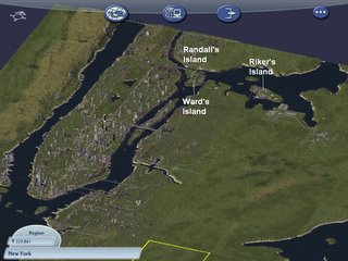
Fast forward a few months, to an interview in BitsBytesPixelsSprites with Elliot Hanson, who is recreating the entirety of New York City pixel by dimetric pixel in SimCity. The interview has some stunning images, but there’s even more on Elliot’s own blog, The New York City Journals. I especially like how some projects are seasonal or event-driven, animated by scripts built into the objects — for example, there is a Thanksgiving day parade, and a recreation of 9/11.

Macysthanks.jpgNot surprisingly, Elliot is also playing with Google Earth, collecting models from 3DWarehouse of New York Buildings. All this leads to an obvious question: Might it not be possible to export SimCity content as a SketchUp model, ready for positioning in Google Earth? Pixel art in Google Earth would be quite a trip, and a layer in Google Earth with Elliot’s work in it would definitely give it wider exposure. We know it’s possible to export 3D content from Second Life and World of WarCraft, as shown by Eyebeam’s OpenGL Extractor, so why not with SimCity?

And thinking further ahead, if/when Google Mars comes out, the opportunities for populating that planet with SketchUp models should make for some excellent collaborative creativity. Anybody up for a chalet with view overhanging the edge of Valles Marineris? It would make for an interesting mirror world/virtual world hybrid, especially as the Mars imagery won’t come with pre-existing infrastructure on it. Hmm, Martian Chronicles, the MMORPG. Isn’t it great we live at a time when such ideas aren’t outlandish?

Oops: NASA & Google launch event delayed

Spaceref.com now reports:

Editor’s update: While this [collaboration] announcement will still happen, NASA ARC PAO now says it has been delayed until a date that has been “mutually agreed upon by NASA and Google.”

As for what this announcement will be about, Romyn in the comments makes a good case for it being iEarth, as written up by New Scientist:

Called iEarth, the NASA software scours EOS databanks for information and converts it into a file that can be viewed via Google Earth. Choosing a spot on the planet’s surface will prompt iEarth to display ground-based measurements for that location, as well as data relating to the atmosphere and space above it.

It’s due in April, says NASA. Maybe Google didn’t want to pre-announce, or else iEarth is being rebranded YouEarth:-) (Via tobedetermined!)

[Update 20:56 UTC: Keith Cowing’s “Editor’s update” on NASA Watch is even better:

While this announcement will still happen, NASA ARC PAO now says it has been delayed until a date that has been “mutually agreed upon by NASA and Google.”. ARC PAO”s Laura Lewis also chided me for posting an internal memo. I guess it did not occur to her that sending an email to several thousand people about a “kick off event” is tantamount to announcing it publicly since the memos get forwarded almost instantly. Indeed, that’s the point of such widely distributed emails in the first place – messages that carry no admonition about further dissemination.

Moral of the story: Don’t ever, ever tell bloggers anything that is not for blogging without telling them it is not for blogging:-)]