damaged_doll: Omg omg!!! Every 1 must try this!! […] U can go anywhere in da world and get satilite pictures really close up and yeah. Squee!!! Why need 2 travel anywhere when u have this!!!
Category Archives: Reviews
Chicago Tribune columnist makes stuff up
A very confused James Coates in the Chicago Tribune does a comparison between Google Earth and MSN Virtual Earth, and doesn’t once mention Google Maps. He also gets his facts wrong on several counts, for example:
With the fancy satellite photos replacing (if you want) traditional road and street maps, both outfits offer slick tour features.
That’s not the case, clearly. But the biggest problem with this column is that he basically makes up how he assumes Bill Gates must have come across Google Earth, to which Virtual Earth is the response:
Word has it that Bill Gates, potentate of propeller heads, went bonkers when he sat down, logged on to www.earth.google.com and saw Google’s stunning marriage of satellite photos and Web search engines.
It went something like this: Gates typed in a street address, town and state and watched as an image of the entire Earth floating in space began to spin.
It goes on, until he has Gates ordering development of his own version. “Word has it”? Google Earth only came out three weeks before MSN Virtual Earth. Gates would have seen Keyhole, Google Earth’s precursor, and could have done so ages ago, though not at that URL. Furthermore, it’s pretty well documented that Virtual Earth emerged from a company-wide contest, and that it was put on a fast track by Gates in response to Google Maps:
Google released Google Maps in February, a time when [Mark Law, lead product manager for Virtual Earth] said Microsoft already was working on Virtual Earth as the result of an idea sent to what he called the “world’s coolest suggestion box.” He explained that every year at Microsoft, employees can suggest a product or an idea they think should be developed and have the opportunity to present it to Microsoft Chairman and Chief Software Architect Bill Gates.
The idea for Virtual Earth found its way to Gates last fall. He decided in February 2005 that the product should be ready for launch by July, Law said.
So either Law is lying, or Coates just makes stuff up.
MSN Virtual Earth: Last impression (promise)
Justed wanted to wrap some things up, and then stop blogging Virtual Earth, as we’ve now determined it is not a competitor to Google Earth, and this blog is about Google Earth and its competitors. Here goes:
1) Other sites have noted that with Virtual Earth, driving directions are outsourced to the much less sexy Microsoft Maps site, in contrast to Google Maps.
2) The black-and-white maps are sometimes more detailed than what Google Maps can offer for a certain spot, but are also considerably older, many people have found. When it comes to viewing Apple’s HQ in Virtual Earth, general hilarity ensues (q.v. Google Maps’s version), as the Register first picked up on. The World Trade Center towers are also still standing in Virtual Earth.
3) Virtual Earth lets you use your mouse’s scroll wheel to zoom in and out, like in Google Earth. It’s a nice idea, though the implementation of it drags, to the extent that I never noticed I could do it until I read about it.
4) Finally, Lifehacker picks up on the fact that if you zoom past available resolutions in satellite view, Virtual Earth will go through with the zooming animation before letting you know if can’t get any closer. That should be an avoidable extra step.
And that’s all. Should anyone come up with clever tools for converting Virtual Earth results into Google Earth-compatible KML (and why not?), I’ll certainly blog it.
Early notable reviews of MSN Virtual Earth
PC World: Bizarrely, Dennis O’Reilly compares MSN Virtual Earth with Google Earth, and not once mentions Google Maps. He is impressed with Google Earth, “However, the MSN product opens in any browser.” Well yes, and so does Google Maps. Google Earth is a browser.
The Seattle Times: Provides interesting context behind what we might as well start calling the Map Wars. Also: Location finder should be accurate to within 250 meters, according to Microsoft. And in contrast to PC World, The Seattle Times get this right: “MSN’s Virtual Earth is a direct competitor to Google Maps.”
Infoworld: Interesting details on how Location finder works. It looks like it might also work for mobile phones, according to the article.
Silicon.com: Even more on the technology behind Location finder.
MSN Virtual Earth: Second Impressions
Now that Virtual Earth has launched for real, I’ve had a chance to confirm my first impressions. They all still stand. What I reviewed then is what we got this morning.
Some added notes: Where Virtual Earth really shines is inside many US cities. The multiple searches work well, and while both Virtual Earth and Google Maps often use the same images, Virtual Earth lets you zoom in all the way if the image allows it, while Google Maps maintains a constant maximum magnification across the globe. For those who visit many different US cities regularly, maintaining a scratch pad with favorite places for each city and then bookmarking these views does indeed add value. Google Maps does have far cleaner and better-looking maps, in my opinion — its hybrid view is especially well-designed.
In its current incarnation, Virtual Earth is useless outside the US. It offers no satellite imagery and no mapping details of any use. For the rest of the world, Google Maps is the way to go. For now, there simply is no point in building sightseeing sites like these with Virtual Earth.
One inexplicable lapse for Virtual Earth is New York City, which contains no high-resolution imagery, but instead contrasty black-and-white pictures that look better turned off. For example:

The combination of dropping the ball in Europe and New York — the two places I consider home — went a long way to creating my initial negative impression of Microsoft’s effort. But if you live and work in Atlanta, initial impressions are bound to be a whole lot better.
Still, my second impression is that Virtual Earth is much more finely honed as a Yellow Pages on steroids, while Google Maps is first and foremost a robust mapping architecture on which services can be built √Ü la carte, or perhaps licensed to third parties who themselves go on to build scratch pads and multiple dynamic searches. We’ll have to wait and see how Google decides to make money off Maps. (Microsoft is also a lot pushier in the side-sell to MSN spaces et al. Nothing wrong with that — it’s a free product, after all.)
Some more Virtual Earth UI quirks:
1) Because Virtual Earth sometimes lets you zoom in especially close, you don’t always get proper feedback from the slider. You’ll think you’re zoomed in all the way, but you can in fact still get closer. This sort of defeats the purpose of having a slider.
2) Also, I keep on having trouble when I want to initiate a new search. My old searches continue to populate the other text box, which leads to bizarre results.
3) Finally, if after a search for pizza in my current view of New York I decide to head on over to the Caribbean, I end up with Florida’s Southermost pizza parlors listed to my left. Head on over to Europe, and I’m treated to Maine’s easternmost pizza parlors. These dynamically updating searches need to be restrained — they’re being a little overeager.
Geobloggers in the (Daily) News
The New York Daily News has a piece on how Geobloggers.com adds functionality to Google Earth.
Big picture: Mainstream media moves from writing articles about the browser to writing articles about things you can do with the browser. Sort of like how it was in 1995.
MSN Virtual Earth: First impressions
[Update 20:00 UTC: MSN Virtual Earth is down until Monday’s official launch. This was just a scheduled trial run, says a developer, who also promises more global content next time round. So we can do this all over again tomorrow.]
MSN Virtual Earth went live overnight. Upon first use I was a bit underwhelmed, because this is what happened to me in short succession:
1) I first got to Virtual Earth in Safari, for which it turns out the drop-down menus don’t work, which rather limited my options in that browser. So I started again in Firefox.
2) I aimed for Stockholm, but had to go there manually, as Virtual Earth did not know where it was (Google Maps does). While Google Maps does street-level mapping for places in the US, Canada, Japan, Ireland and UK, it turns out Virtual Earth only has street-level mapping in the US, with Canada and Mexico getting maps that are somewhat less detailed. Virtual Earth does pepper the globe with cities and borders, but it does this somewhat randomly:

(Google Maps doesn’t have any map data for the rest of the world, but Google Earth does, including street-level overlays for all of Europe, and any other library of placemarks you care to import.)
3) I then switched to Virtual Earth’s Aerial photo mode and discovered that satellite imagery only exists for inside the US. The rest of the world has to make do with a very low-resolution simulacrum. (For now. It’s promised for the autumn.)
4) Argh! You can’t scroll from Kamchatka to Alaska! You have to go the other way round! Bad Virtual Earth!
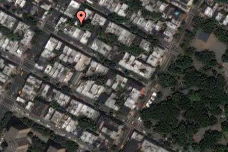
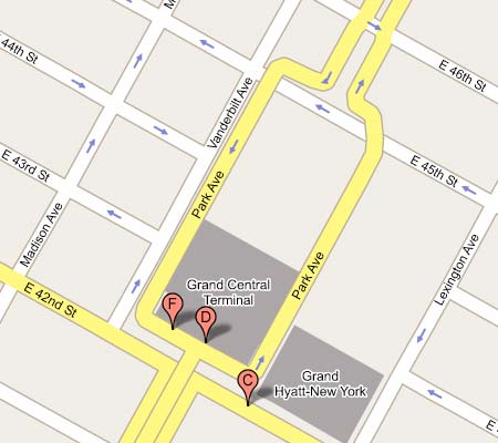
5) On to New York, my other reference for maps. Black & White aerial photography? How very Cold War. And what’s with the wiggles in my avenues and streets? 1st Ave. looks like a lazy river meandering down Manhattan. Did somebody get drunk doing NYC?
St. Marks Place, New York, in Virtual Earth:
St. Marks Place, New York, in Google Maps: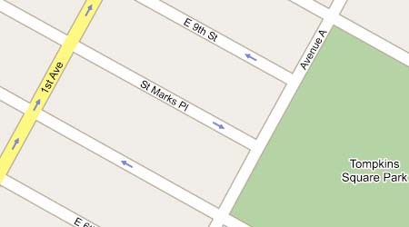
But then things got better for Virtual Earth. By the time I got to Washington DC, the highest-resolution aerial photos were in color. In fact, in DC, Virtual Earth, Google Maps and Google Earth all use the exact same satellite imagery (just check the car placement). Virtual Earth actually lets you zoom in closer than Google Maps in DC, to the full resolution of the image. (Google Earth lets you zoom in even closer, but without extracting any more information from the image.)
Virtual Earth also comes with some features that Google Maps does not have. The scratch pad lets you store businesses you’ve found in searches for future reference, and these are saved between sessions. I haven’t yet found a way to store my own non-commerical places of interest, however. (In Google Earth, you can make placemarks for any location.)
If you do a local search for Pizza in Virtual Earth (in the US), and then scroll off in a certain direction, Virtual Earth will continue to find the 10 closest pizza parlors. In Google Maps, you have to re-click the Search button after scrolling. Virtual Earth’s implementation is similar to how some of the dynamic network links in Google Earth work. But even in Google Earth, a local search for Pizza returns static results that are kept in your places menu until you delete them. I suspect this is a conscious choice by Google, as it can be a little disconcerting to have your search results disappear on you. Ideally, there’d be an option, so that the user can choose their preferred search mode.
Virtual Earth also lets you see the results for up to three such local searches. Google Maps only lets you do one search at a time. Multiple simultaneous results are useful if you’re looking for pizza parlors near McDonalds’s, but in that case you could use Google Earth, which lets you add as many search result layers as your hardware can handle. (It already has schools and hospitals and such as dynamically updated layers.)
Some further observations:
1) The “immersive” quality of having the image bleed to the edge of the browser window and then placing floating translucent text areas on top of this is not as wonderful as it sounds. There is a lot of fetching and rendering being done underneath those windows that we have no use for. Google Maps places the text areas next to the map, which seems cleverer for a browser-based service. It feels like Virtual Earth aspires to being Google Earth, when in fact it can only ever compete with Google Maps, locked as it is within the confines of a 2D browser.
2) If you’re zoomed in too close as you cross the border into Canada, the scrolling stops. You have to zoom out before you can continue North. That feels a bit confining.
3) Virtual Earth’s search fields are a bit confusing on first approach. Do I need to fill both in? Just one? What if I want to do a new search — do I have to erase the terms in both fields? Google Maps’s GUI makes the choices clearer. Same goes for the view options: Map/Satellite/Hybrid is easier to intuit than two buttons and a pull-down menu.
4) Virtual Earth comes with “Locate me” functionality, which apparently uses wi-fi to find you on the map, or else positions you from your IP address. This could be of use if you’re a road warrior arriving in a new town and you are too tired find out where you are before searching locally. But otherwise, this feels like a toy, or a solution in search of a problem.
In sum, Virtual Earth competes with Google Maps, not Google Earth. Six months ago, Virtual Earth would have been amazing. Today, it gets compared with Google Maps, which two days ago added the Hybrid view — the feature that was supposed to be Virtual Earth’s trump card.
Virtual Earth is newer than Google Maps, so its map and image database is spottier at the moment, but this is something that tends to get filled in over time. (The orthogonal photography from Pictometry isn’t available yet.) As for features, Virtual Earth boasts functionality which Google Maps does not have (multiple simultaneous searches, the scratch pad, and Locate me), but Google Maps feels a lot cleaner and leaner, with better-looking results and seemingly more apt to let third parties build additional functionality via a much-praised API. Virtual Earth also has Javascript map controls that hackers, er sorry, “developers”, are allowed to use, so time will tell which API proves to be more amenable to mashups.
Still, Google Earth is a completely different beast from Virtual Earth. Microsoft has not built a next-generation Earth browser, but a competitor to Google Maps.