[Update 20:00 UTC: MSN Virtual Earth is down until Monday’s official launch. This was just a scheduled trial run, says a developer, who also promises more global content next time round. So we can do this all over again tomorrow.]
MSN Virtual Earth went live overnight. Upon first use I was a bit underwhelmed, because this is what happened to me in short succession:
1) I first got to Virtual Earth in Safari, for which it turns out the drop-down menus don’t work, which rather limited my options in that browser. So I started again in Firefox.
2) I aimed for Stockholm, but had to go there manually, as Virtual Earth did not know where it was (Google Maps does). While Google Maps does street-level mapping for places in the US, Canada, Japan, Ireland and UK, it turns out Virtual Earth only has street-level mapping in the US, with Canada and Mexico getting maps that are somewhat less detailed. Virtual Earth does pepper the globe with cities and borders, but it does this somewhat randomly:

(Google Maps doesn’t have any map data for the rest of the world, but Google Earth does, including street-level overlays for all of Europe, and any other library of placemarks you care to import.)
3) I then switched to Virtual Earth’s Aerial photo mode and discovered that satellite imagery only exists for inside the US. The rest of the world has to make do with a very low-resolution simulacrum. (For now. It’s promised for the autumn.)
4) Argh! You can’t scroll from Kamchatka to Alaska! You have to go the other way round! Bad Virtual Earth!
5) On to New York, my other reference for maps. Black & White aerial photography? How very Cold War. And what’s with the wiggles in my avenues and streets? 1st Ave. looks like a lazy river meandering down Manhattan. Did somebody get drunk doing NYC?
St. Marks Place, New York, in Virtual Earth: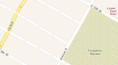
St. Marks Place, New York, in Google Maps: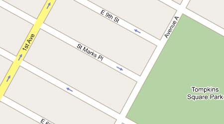
But then things got better for Virtual Earth. By the time I got to Washington DC, the highest-resolution aerial photos were in color. In fact, in DC, Virtual Earth, Google Maps and Google Earth all use the exact same satellite imagery (just check the car placement). Virtual Earth actually lets you zoom in closer than Google Maps in DC, to the full resolution of the image. (Google Earth lets you zoom in even closer, but without extracting any more information from the image.)
Virtual Earth also comes with some features that Google Maps does not have. The scratch pad lets you store businesses you’ve found in searches for future reference, and these are saved between sessions. I haven’t yet found a way to store my own non-commerical places of interest, however. (In Google Earth, you can make placemarks for any location.)
If you do a local search for Pizza in Virtual Earth (in the US), and then scroll off in a certain direction, Virtual Earth will continue to find the 10 closest pizza parlors. In Google Maps, you have to re-click the Search button after scrolling. Virtual Earth’s implementation is similar to how some of the dynamic network links in Google Earth work. But even in Google Earth, a local search for Pizza returns static results that are kept in your places menu until you delete them. I suspect this is a conscious choice by Google, as it can be a little disconcerting to have your search results disappear on you. Ideally, there’d be an option, so that the user can choose their preferred search mode.
Virtual Earth also lets you see the results for up to three such local searches. Google Maps only lets you do one search at a time. Multiple simultaneous results are useful if you’re looking for pizza parlors near McDonalds’s, but in that case you could use Google Earth, which lets you add as many search result layers as your hardware can handle. (It already has schools and hospitals and such as dynamically updated layers.)
Some further observations:
1) The “immersive” quality of having the image bleed to the edge of the browser window and then placing floating translucent text areas on top of this is not as wonderful as it sounds. There is a lot of fetching and rendering being done underneath those windows that we have no use for. Google Maps places the text areas next to the map, which seems cleverer for a browser-based service. It feels like Virtual Earth aspires to being Google Earth, when in fact it can only ever compete with Google Maps, locked as it is within the confines of a 2D browser.
2) If you’re zoomed in too close as you cross the border into Canada, the scrolling stops. You have to zoom out before you can continue North. That feels a bit confining.
3) Virtual Earth’s search fields are a bit confusing on first approach. Do I need to fill both in? Just one? What if I want to do a new search — do I have to erase the terms in both fields? Google Maps’s GUI makes the choices clearer. Same goes for the view options: Map/Satellite/Hybrid is easier to intuit than two buttons and a pull-down menu.
4) Virtual Earth comes with “Locate me” functionality, which apparently uses wi-fi to find you on the map, or else positions you from your IP address. This could be of use if you’re a road warrior arriving in a new town and you are too tired find out where you are before searching locally. But otherwise, this feels like a toy, or a solution in search of a problem.
In sum, Virtual Earth competes with Google Maps, not Google Earth. Six months ago, Virtual Earth would have been amazing. Today, it gets compared with Google Maps, which two days ago added the Hybrid view — the feature that was supposed to be Virtual Earth’s trump card.
Virtual Earth is newer than Google Maps, so its map and image database is spottier at the moment, but this is something that tends to get filled in over time. (The orthogonal photography from Pictometry isn’t available yet.) As for features, Virtual Earth boasts functionality which Google Maps does not have (multiple simultaneous searches, the scratch pad, and Locate me), but Google Maps feels a lot cleaner and leaner, with better-looking results and seemingly more apt to let third parties build additional functionality via a much-praised API. Virtual Earth also has Javascript map controls that hackers, er sorry, “developers”, are allowed to use, so time will tell which API proves to be more amenable to mashups.
Still, Google Earth is a completely different beast from Virtual Earth. Microsoft has not built a next-generation Earth browser, but a competitor to Google Maps.