- Education technologist Bob Kaehms is working on integrating the Drupal content management system with Google Earth, with the aim of creating a teaching aid:
I’m looking for teachers to work with to create some geospatial based content. My ultimate goal is to make the work (eventually) available as a drupal module.
- Intriguing news: NASA World Wind’s developers are making a major push to beef up support for KML, report both The Earth is Square and Bull’s Rambles. (This includes the rendering of 3D KML buildings, though it doesn’t look like SketchUp models are supported.)
I think this is World Wind’s most important task right now — although World Wind add-on content modules are impressive, they are hard to make and hard to tweak, and this works against their wider adoption. KML, and especially the network link, is a stroke of genius in that it can very easily be manufactured on demand, in real time, by server-side applications.
- This site looks a bit spammy at first (like, who clicks on content like that?) but WorldWindData.com seems to offer legit sizable cache packs for World Wind, free. (Scroll down.)
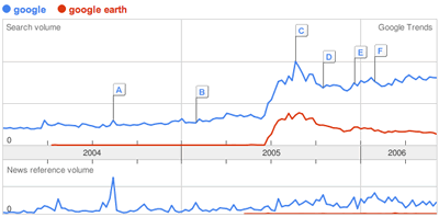
- If you want to get a feel for how important Google Earth has been to brand Google, check out this Google trends graph:
All posts by Stefan Geens
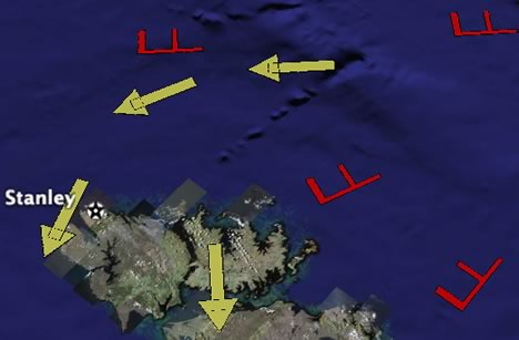
Battleship Earth
University of Southern California’s Julian Bleecker has a very interesting summer project going: Playing Battleships using Google Earth as a game board, but with the twist that you have to physically visit the location on the board you want to attack, using your mobile phone to “call in” a strike.
There have been previous instances of real-time mobile gaming using phones, but this is the first time I’ve seen Google Earth used in the process. Julian has an interesting notion to describe this kind of gaming: It’s a “1st Life/2nd Life mashup”, in that real-world actions impact the state of a virtual world.
Implementation is rather spotty, but it doesn’t matter at all — this is a brave new use for Google Earth, and one that makes absolute sense, with hindsight: Because Google Earth aspires to be a mirror world, it will always be open to receiving inputs from the real world, as there is a one-to-one correlation between places on Earth and places on Google Earth. This happens to be the main difference between the likes of Google Earth and imaginary virtual worlds like Second Life; Julian’s Battleships proof of concept drives this home.
Going somewhat speculative, now: The next generation of mobile phones will know exactly where you are and will be able to tell it to you, to your mobile applications, to your trusted friends (and to operators and the government). The opportunities for feeding your location to a mobile Google Maps and to Google Earth are self-evident. I think this is why so much effort is being expended by Google, Yahoo! et al to secure a place on your mobile’s screen now for both maps and search. In the future, your mobile phone will be your avatar cum concierge cum beacon. The only question is, whose software will you be using? I reckon that the company with the best global base map will be at a natural advantage.
Short news: SketchUp to Google Spreadsheets, anyone?
- Make: begins delivering SketchUp models alongside some of its Maker project podcasts. (Make has already been attaching PDF plans to its shows for a year now.) Great idea. There is no reason why travel podcasts shouldn’t attach KMZ files to their shows.
- Over on SketchUp Pro forums, Ruby programmer “IDEVFH” has been playing with integrating Google Spreadsheets with Google SketchUp, so that you could, for example, connect a bill of materials to your SketchUp model and have it update as you refine your model. He wants to know if this is of interest to anyone.
- Gerardo64 has step-by-step instructions on how to turn any RSS feed (that contains datelines or placenames) into a KML network link, using Geonames’s RSS-to-GeoRSS converter.
- Matt Perry looks at GDAL/OGR, a command-line tool for PC and Linux that will soon be able to convert Shapefiles into KML. (Link to GDAL/OGR homepage)
- Greenpeace puts its Bering Sea ship tour onto Google Earth (KML link).
Short news: Google Aargh; Bentley update; Earth Climber
- Pirates of the Caribbean II has a promotional website up that uses Google Earth to dispense wallpapers, trailers and what have you. Cute, but you’re not missing much if you skip it. (Via)
- AECNews.com notes that Bentley’s integration with Google Earth and SketchUp continues apace. Models can be imported directly from Google 3D Warehouse, and in “the near future” you’ll be able to export from Microstation to the SketchUp SKP format.
- Israel’s Ynetnews.com has a rare story of moderation on both sides in this current atmosphere of escalation. The article refers to this post on Google Earth Community from a few months ago documenting the displacement of Palestinians in the aftermath of Israel’s independence in 1948. (Comments on the article are a bit disheartening, however.)
- Kudos to Frank at Google Earth Blog for noticing that the European countries previously supported in Maps now also have all their data available via Google Earth’s information layers. I never had those turned on, as this stuff was useful in the US only. That will now change.
- The things I will do for this blog: For 100 euros, I will gladly go to Paris for the day from Cambridge to take part in a Google Earth usability study (and have enough money over for a jaunt around the Centre Pompidou). You too can apply. If we both make it in, how about a mini blog rendez-vous?
- I don’t think I’ve linked to this before: Earth Climber, “Using Google Earth to locate climbing destinations worldwide.” (Via You gotta climb!)
- Golftraxx provides yet another opportunity for golf aficionados to integrate their passion with Google Earth. Press release.
GIS: What’s there to talk about?
I haven’t indulged in metablogging for some time now, so excuse the lapse.
Re Dave Bouwman’s post on the supposed lack of conversations on GIS blogs, with follow-ups from Adena Schutzberg , Frank, Allan Doyle and James Fee. Some thoughts:
Conversation != blogging. I know the “blogging is a conversation” meme is all the rage right now, but let’s not confuse analogies with isomorphisms. Blogs are not conversations; not exactly, at least. More accurately, they’re serial monologues, with an opportunity for feedback. They are also, I hope, a little more considered than the average conversation, and a little more researched, with links for attribution.
The corollary: Comments != conversation. We who have blogs and and have a worthwhile point to add will write a post. I tend to use comments when I see a question unasked, an error, I can make a pithy point or I know of a relevant link the author might like. I leave diatribes for my own blog.
GIS is more like rocket science than evolution. By that I mean that there are very few controversies in the field that stir civilians. GIS is relatively devoid of ideological turf wars. The only times I have seen Google Earth users get red in the face is when political boundaries and placenames have not been to their liking.
At the same time, GIS software seems to be dominated by a few benevolent Hobbesian Leviathans (I’m thinking ESRI and Google), whose subjects appear quite well served by the regime. Whenever there is talk about manning the barricades, there is indeed a spate of comments, usually on James Fee’s blog or now also on GIS dirtbag. NASA World Wind blogs also tend to be fired up by their perceived underdog status. Otherwise, there is very little sense of the outrage and injustice that is so vital for the cultivation of an argumentative blog culture.
But we can ask why GIS blogs don’t more often all pitch in on common topics, such as we’re doing in the aftermath of Dave’s post. Perhaps it’s because we’re all niched? This blog is about Google Earth. I consciously try not to repeat news already reported on at Planet GeoSpatial. In a field where news and analysis is more important than opinion and ideology, perhaps this is what the blogosphere can be expected to looks like.
Google Earth hack: Weather & map symbols
Somebody was asking whether there is a way of drawing map and weather symbols directly onto Google Earth — icons aren’t any good, as they always face you; these symbols definitely need to be able to point in a specific direction.
You can easily place individual objects onto Google Earth using SketchUp or any number of converters, but if each object is going to be unique, then the time and file size required are going to be substantial. Might there be a better way?
Once again, I suspected the recent integration of SketchUp and Google Earth might hold a solution. After some experimenting, I hit upon this hack:
In SketchUp, I drew an arrow symbol. I extruded it slightly, and then I exported it to Google Earth using the Export menu item.
I took the resultant KMZ file, changed the suffix from .kmz to .zip, and unzipped it. Inside, I looked at the “doc.kml” file in a text editor.
Here it gets interesting. The data for the arrow symbol resides in the “models” folder, where it is referenced via KML in doc.kml; such referencing can be done repeatedly, creating many different instances of the same symbol. Each time, the KML can define the latitude, longitude, orientation and scale of the symbol instance. (Realistically, scaling needs to be set at 1000x or more to move from SketchUp size to Google Earth size.)
This means that you could mark up a map programmatically, rather than manually, for example by using weather data at specific coordinates as display parameters for the symbol. Is the wind coming from the NW? Then set the <heading> tag to 135 degrees. Once you’ve created a set of basic symbols, all you need to do is write KML to reference them.
I’ve made a sample such file, which uses two different symbols multiple times, each time altering the location and direction slightly. It works well, though there are a few caveats:
- You have to give the symbol a vertical thickness or have it be somewhat off the ground, else your work will disappear underground.
- As before, the symbols do not curve along with the Earth, so this solution does not scale at the more extreme outward zoom levels.
The sample file I made is static and quite crude, but there is room here for further innovation in visualization techniques — for example, you could make a dynamic network link and return KML as a function of the bounding box, so that symbol size and even the number of symbols displayed could be derived from your zoom level.
Below the fold, sample KML for depiciting two arrows.
Bombings in Mumbai
Google Earth Community has a post with KML for the locations of the attacks. Here is the KML pasted into Google Maps (turn on Satellite view). Hang in there, Mumbai.
[Update 13:09 UTC: Lasting News has more links to mapping and community resources built in the aftermath of the attacks.]