Avi Bar-Ze’ev has his take on the relative merits of Google Earth and Nasa World Wind. And the potential threat facing both of them.
As for me, I’m off to the Proms now, so no more blogging for me today (I suspect).
Avi Bar-Ze’ev has his take on the relative merits of Google Earth and Nasa World Wind. And the potential threat facing both of them.
As for me, I’m off to the Proms now, so no more blogging for me today (I suspect).
Some recent content for Google Earth that I’ve enjoyed:
Some interesting links & news:
Pamela at Secret Tenerife does a much more thorough job of translating the local media’s stories about the the recent aging of Google Earth’s local satellite imagery. Tidbits:
It appears that someone from Google came to the archipelago in August 2005 and one of their commercial directors reached an agreement, “free of economic exchanges”, with Grafcan for Grafcan to provide the images. Apparently, Grafcan are the first European company to obtain such an agreement.
Bernardo Pizarro, managing director of Grafcan, says that they have received a lot of complaints from users who want to see up-to-date images.
There is much more there worth reading. The most worrying aspect of her post, however, is that she points out Grafcan’s imagery is censored. Here is what the military base at Gando looks like:
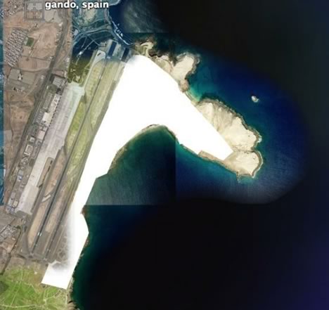
This is always the danger if you accept locally generated imagery subject to national security laws. I’m betting DigitalGlobe’s imagery wasn’t censored. So maybe, if what James Fee reports is true, we can soon have it back?:-)
Cartography has a go at the Spiegel article “How Google Earth Is Changing Science” for its utter lack of understanding of GIS, so I don’t have to, but I can’t resist this little excerpt:
Google Earth wasn’t really intended for scientists. The Google search engine’s extraordinary globe, which is made up of hundreds of thousands of satellite photos and aerial images, was initially meant as a game for virtual hobby pilots. Users discovered that it was fun to fly over their own homes, swing up into space and, within seconds, swoop back down into the depths of the Grand Canyon. But now the scientific community is discovering how useful the software is for their own work.
What twaddle.
And why is it that it is always the least knowledgeable articles that get the widest exposure? Here is the much bastardized UPI writeup.
The Earth is Square is upset that the Google Earth team gets recognition for its efforts in the wake of Hurrican Katrina. World Wind did it better, he argues. I can’t comment on the relative merits of the World Wind community’s efforts, as I wasn’t aware of them. Clearly, most rescue professionals in the field ended up using Google Earth’s solution at the time — maybe TEiS can explain why that is beyond alluding to better marketing on the part of Google — at that time, the popularity of Google Earth was due overwhelmingly to word of mouth. Is it Google Earth’s ease of use? Is it because Google’s servers could handle the extreme load?
Google Earth general manager John Hanke announces on the official Google blog that the Google Earth team was recognized last week by the National Geospatial-Intelligence Agency for their work last year to bring timely satellite images of the areas devastated by Hurricane Katrina to the public (and to rescuers).
That was the first demonstration of the good that can come from democratized access to up-to-date geospatial data which a year earlier would have cost individuals a fortune. Soon after, in the aftermath of the Pakistan quake, Google Earth would be able to demonstrate this again.
Jason Stege has created a KML object class for PHP5 that speeds up the creation of KML files, keeps the code tidy, and also lets you zip the result into a KMZ file. If you code in PHP, you definitely want to take a look at his work, which is freely available for download on his blog.