All posts by Stefan Geens

Altitude ranking: Potent patent?

I don’t know much about patent law, but I do know Dutch, so I thought I’d make myself useful by airing some questions about a Dutch article in Emerce from last weekend that profiles Erwin Nikkels of Globe Assistant, the company behind Earthbooker.net.

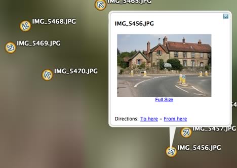
The article explains that the company has developed EarthConnector, described as a technology that allows companies and organizations to plot their databases on Google Earth, Maps and comparable apps. Earthbooker.net is based on it. Erwin is then quoted as saying, “In the Netherlands we have a patent on our technology and there are now patent applications in 120 countries.”

I’ve blogged Globe Assistant’s patent before, albeit in a snippy fashion, but this time I asked Erwin for a link to it. (Dutch patent sites are impervious to my searching skills). He was happy to forward it to me.

Here is the link. (Click on “Save full document” to get the entire PDF.)

The title of the registered patent is “Altitude Ranking: het waarderen van data afhankelijk van de ‘hoogte’.” In English it is described thus: “Internet search result display method, uses altitude ranking system to link relevance of objects to viewpoint above virtual globe or world map.” It was applied for on August 12, 2005 and granted on December 1, 2005.

Here’s a translation of the excerpt, in full:

Altitude ranking is a method for the efficient sorting, storing, ordering and presentation of digital data objects, where the relevance of the objects is coupled to the height of the user above a virtual globe (like Google Earth) or digital map.

Increasingly, data on the internet is presented with the help of this kind of graphical environment. With the altitude ranking mechanism it becomes possible to present the most relevant information in a manageable way to the user.

Depending on the ‘height’ of the user, a selection is made of the available data. When the user’s height is altered, automatically a new selection is made and presented.

The patent goes on to explain in detail how this works: Objects are ranked by relevance to the user and then sorted in layers, with the most relevant objects becoming visible in the highest layers above the globe or map. As you zoom in, more and more (less relevant) objects become visible.

The patent differentiates between two ranking methods: External ranking and self ranking. With external ranking, an object’s relevance is determined by an external calculation. An example of external ranking is an RSS feed of news items being ranked according to their recency. With self ranking, the rank of an object depends on its popularity in a community, as determined by clicks or zooming behavior. More popular objects first become visible at a greater height.

One mentioned use of this method is for business promotions: Hotel chains engaged in a promotion could have their hotels begin to be shown at a higher altitude, for example.

Another example is for search results returned by the Yellow Pages: The most relevant results would start to be shown at the highest layers. For public agencies, risk maps could show the most dangerous objects from the highest layers.

The patent also covers the ability to use relevance to determine an object’s shape or color: For example, if you were previously on a web page about a specific real estate property, then this property could be highlighted when you subsequently view it on a globe or map surrounded by other objects.

I’m pretty sure I’ve excerpted the patent document fairly, but I would certainly welcome corrections or amendments.

What I’m curious about, as a patent neophyte, is whether this is the kind of patent GIS and search programmers recognize as being substantive — would you consider this method to be patentable? Would you licence it? Is this method something you could see yourself develop as a matter of course in response to a client’s needs, or does it represent a non-obvious yet elegant solution to the problem of visualizing geospatial data inside the confined space of a monitor screen?

New from 3D Nature: Textured terrain using COLLADA

3D Nature, whose Visual Nature Studio lets you build 3D landscape visualizations, has just updated their exporter, Scene Express, so that it takes advantage of some of Google Earth 4’s new KML features. 3D Nature’s Chris Hanson wrote in to explain what’s new:

I think we’re the first offering textured, georeferenced terrain translation to KML, using the COLLADA 3D object format. We also can do textured georeferenced buildings, and now proper fixed-size foliage.

KML support in the previous version of Scene Express was criticized on this blog because KML icons were used to represent foliage, which broke Google Earth’s user interface. How does the new version fare?

I haven’t seen a sample yet of the new improved foliage, so I will reserve judgement on that, but I have just seen the textured terrain feature, and this is indeed new and impressive.

Before, if you exported LIDAR-based terrain to KML, you just got a (detailed) blob built from a collection of geometries using KML:

blob.jpg

Now, Scene Express lets you drape texture data over the same LIDAR landscape and then export it as a COLLADA .dae file wrapped inside KML. If you use Google Earth’s underlying imagery as your texture, you get a very nifty result indeed:

Visible:

with.jpg

Invisible:

without.jpg

In effect, you can now improve on Google Earth’s default height mesh, simply by adding your own local data if you feel you need more detail. Does anybody have LIDAR for the Matterhorn? That mountain still needs some help:-)

Short news: Flickr heat map for GE

  • What a great resource: A KML choropleth map (I can pretend I knew what that is, but in fact I had to look it up) of Flickr photos as a network link. Click on a square and it takes you straight to the relevant Flickr map. Now you can have your Flickr photos and Google Earth too. How did this manage to live in the wilderness without bloglove for over two whole weeks? (Via The Map Room)
  • It’s good to have validation of Google Earth’s Greenland imagery every so often. (Via The Other Here)
  • Geocoding database Geonames gets a JAVA API. It’s open source, and on SourceForge. (Via Geospatial Semantic Weblog)
  • TYRE Lets you copy waypoints from Google Earth to your TomTom.
  • EPoint2GE converts coordinate data in Excel into KML using VBA. (For PC)
  • Ashley Joyce’s Google Earth animator promises to “dynamically update a 3D model loaded inside Google Earth by using Google Earth Network Link capabilities.” This tool looks like it will be very useful for positioning 3D content just the way you want it. Check out the screenshots in anticipation of the beta.
  • Now you can play Doctor No on the cheap. According to this press release:

    Guardian Solutions today announced and demonstrated the first totally geo-spatial video surveillance system called GView(TM). It incorporates patent-pending technology that upgrades a facility’s digital video recording (DVR) surveillance system to a 3D situation awareness system for rapid threat detection and understanding. As the DVR records video events, GView(TM) isolates and tracks threats (individual, vehicle, vessel …) and displays, through Google Earth(TM), all movements on a 3D site model for a bird’s eye view of all “at risk” assets and video and non-video sensors.

Google Earth for Mac + AppleScript = Geotagger! (and more!)

Mac users suddenly have plenty to rejoice about. What happened?

geotaggericon.jpgCraig Stanton — he of
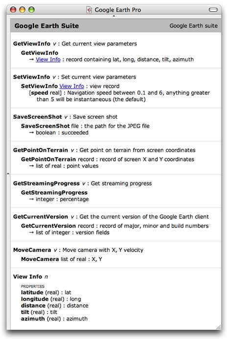
 iPhotoToGoogleEarth fame — just discovered that Google Earth 4 has a basic AppleScript library!

This opens up all sorts of possibilities. For Craig, it allowed him to build what is perhaps the simplest, most intuitive georeferencing application on any platform: Geotagger.

How does it work?

  1. Position Google Earth over the spot where you took a photo. (Need some crosshairs?)
  2. In your finder, drag the photo to the Geotagger droplet.

Done. Geotagger uses AppleScript to read the position of the center of the screen in Google Earth, and adds this to the EXIF metadata of the photo(s) you dropped on it. You can now import these photos into Flickr or Panoramio, where they will be automatically geotagged. If you import these photos into iPhoto, you can use Craig’s iPhotoToGoogleEarth plugin to export them as KML. Only caveat: The photos need to be JPEGs.

Being able to commandeer Google Earth via AppleScript really opens up a Pandora’s box for Mac users. Check out the commands:

ascript.jpg

I had hopes for AppleScript support when GE3 came out for the Mac because I really wanted to build a remote control for Google Earth using my Bluetooth enabled mobile phone and fellow Stockholmer Jonas Salling’s Salling Clicker. Now that’s possible. Here’s the proof, taken outside on Stockholm’s Odenplan last night:

(Geeknotes: The mobile phone in the video is acting as the Mac’s 3G modem via Bluetooth while also simultaneously relaying commands via Bluetooth using Salling Clicker. No, that’s not why it crashed — the current Google Earth 4 Mac beta is a tad unstable if you as much as breathe on the preferences file.)

If you have Salling Clicker, you can download the file containing my (very simple) AppleScript commands for Google Earth. Treat it as a proof of concept; you’ll have to attach the scripts to phone keys yourself. I’m sure AppleScript gurus have ways of turning this into a more polished product.

I can’t wait for increased AppleScript support by Google Earth in the future. Imagine geocoding placenames via AppleScript, or taking screenshots of your house as wallpaper for your mobile phone, or letting GPS devices and location-aware mobile phones show you where you are in Google Earth. In fact, some of these things should even be possible with the current AppleScript library. Apple users, your Google Earth API has arrived.

Jelbert GeoTagger records camera heading data

jelbert.jpgThe Jelbert GeoTagger connects to a Garmin Geko 301 GPS device and fits into a DSLR’s flash shoe. Every time you take a photo the camera triggers the geotagger, which records the precise position and heading of a camera using the GPS device. Later you will add the Geotagger’s stored GPS data to the photo’s EXIF data via an application like RoboGeo (PC) or GPSPhotoLinker (Mac). (The Jelbert Geotagger is £149, the Geko 301 is $246.)

It’s a step forward for georeferencing photos vs. the traditional method of a calculating time-weighted averages of the nearest tracklog points. The holy grail, however, is recording a photo’s position data as EXIF the moment it is taken. Nikon has a cable that lets you do this for the D2X and D200 — the MC-35 ($99), which connects to your GPS device. Or make your own for the D200.

It doesn’t appear like the Nikon-specific solutions can transfer compass data, though, even if you were to use a Geko 301, which has an electronic compass built in. To do that, you still need the Jelbert Geotagger. Here is their demo of how the direction data plays in Google Earth. Good to see directional icons in use!

directions.jpg

What else is left to innovate? Vertical tilt. My Nikon can already sense whether the camera is taking a portrait or a panorama shot, so this feature can’t be too far off. When all that is in place, there is no reason why the KML can’t be made to construct <LookAt> tags mimicking the view of the camera, as Alan Glennon mooted back in January.

(Via Hack a day, Slashdot)

Time-enabled Norwegian weather forecasts

What a difference high production values can make to a weather map in Google Earth. Trond Michelsen of the Norwegian Meteorogical Institute has turned NMI’s forecasts into a remarkable network link. It comes with cute-as-a-button icons, color-coded temperatures (which I really like — check northern Norway) and — the pièce de resistance — it’s all time-enabled. Icons change from suns during the day to moons at night, you can click them for more local info, and if you turn on the preciptiation overlays, you’ll see that cloud layers there match the icons. It just looks so professional. Almost makes one want to live in Norway:-)

norweather.jpg

Trond wrote in with some of the technical details, below the fold.

Continue reading Time-enabled Norwegian weather forecasts

Google Earth features in Saturn video ads

As suspected, Google Earth merely features as video footage inside the new Google Video ads for the Saturn car make, but it’s actually cleverly done. Google Earth in effect becomes a cheap special effects machine for the video ads, making it easy to churn out 22 different ads featuring different Saturn dealers, and then showing the one for the dealer nearest to the user, as determined by the IP address. That’s definitely something new.

Hashem Bajwa of Goodby, Silverstein & Partners, the ad agency that created the ads, wrote in with more info, below the fold.

Continue reading Google Earth features in Saturn video ads