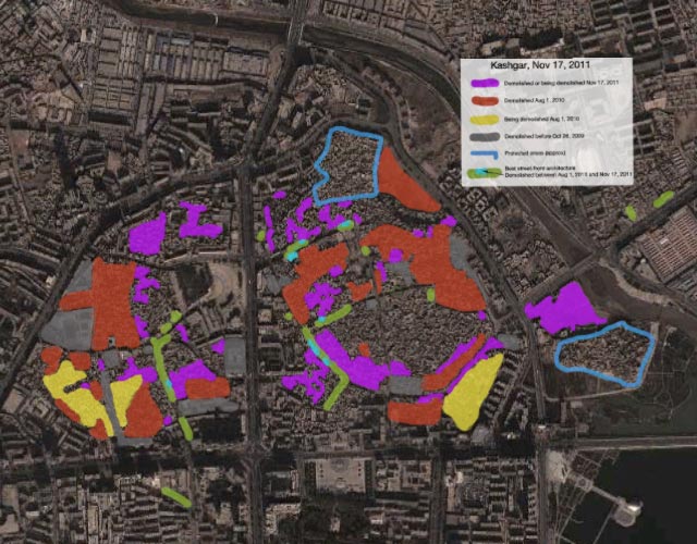
In August 2010, I visited Kashgar, a city in China’s remote far west that for over a millenium helped drive the Silk Route economy, inheriting an old town with distinctive Islamic architecture. My visit was compelled by the news that this old town was in the process of being dismantled by authorities, so I wanted to see it before it was gone. I ended up spending a week documenting and mapping the process, publishing the results in a Google Earth file.
On February 17, 2012, new imagery of Kashgar appeared in Google Earth, taken just three months ago, on Nov 17, 2011. By comparing this new imagery to the older imagery and my notes, I’ve been able to update the map to chart the progress of the old town’s transformation in the 15 months between my visit and the latest imagery. Here it is as a Google Earth file:

Some observations from studying this new imagery:
- Around two thirds of the old city has now been demolished, up from almost half 18 months ago. The goal still appears to be to demolish 85% — there are two designated protected areas that are slated to remain untouched.
- The new satellite imagery does not show wide open spaces where demolished houses once stood. That is because the building of new structures starts almost immediately as old houses are demolished. The best way to look for rebuilt areas is to compare before-and-after structures, which often include construction that does not yet have a roof.
- Some good news: The rebuilt structures by and large appear to be of the same scope and size as the ones they are replacing — there are no further encroachments of large modern tower blocks on the old city core (so far). It also looks like no new larger roads are intersecting the rebuilt areas, though it does seem from Google Earth that new alleys are not being redrawn along old routes (but it is hard to tell).
- Some bad news: Some of the street-facing architecture that I marked on the map as being distinctive when I visited — for the verandas or traditional workshop fronts — appears to have been demolished. I’ve marked these areas in light blue on the map. I was hoping these parts of town would be left alone, or restored, rather than demolished, as they were especially worth saving.
- In demolished areas, some isolated original structures are allowed to remain, and new construction is built around them. This points to some flexibility on the part of authorities. Perhaps some instances of authentic courtyard houses will manage to survive intact, even in the areas slated for demolition.
Thank you for your documentation work.
Stefan, as always, wonderful work. Thanks for the time you put into this and for making your research available for everybody. Some things are easier to understand on the ground while in this case a satellite view is the best.
I did a similar categorization for my advanced imagery class. A classification of old vs. new was constructed and run on Landsat imagery, and it worked about as well, though the imagery was older and lower res. Too bad about the loss of all those old Uighur homes and business; wandering the paths and finding my way back via the cobblestones was one of my favorite things to do there.
it is too bad that those people had to move and those houses either destroyed or rebuilt. There are people who can afford to rebuilt it but there are so many who had to move since they can’t afford to rebuild it. There are many houses make their living by selling groceries and other item in their small shop, but now they don’t have any income after moved in to apartment houses.