- DestinSharks.com has turned a global oceanic sensor web into a great KML network link, displaying hourly updated weather readings from ships participating in the NOAA/WMO Voluntary Observing Ship (VOS) program.
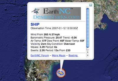
Ship locations show color-coded directional icons depicting wind speed and visibility, with more context if you hover or click — and all observations are time-stamped, so you can navigate through the past 24 hours.
- New blog: Free Geographic Information Tools. Writes its author, Leszek Pawlowicz, in an email:
The first series of posts will mainly cover how to meet or beat most of the capabilities of Google Earth Plus (GPS import and export, spreadsheet import, address geocoding and real-time tracking) using free or cheap software.
Welcome to the sandbox, Leszek.
- Andrew Hudson-Smith tries SketchUp’s Photo Match perspective tool for urban modelling. The verdict: “It significantly speeds up the modelling process for urban visualisation.” The tutorial movies on the Sketchup help site are well worth watching to get an idea of what Photo Match entails.
- The Earth is Square shows off a tool in the forthcoming NASA World Wind that lets you get terrain profile cross-sections for any great-circle line you care to draw. I like. I also like topo maps for Southern Africa.
Yearly Archives: 2007
Google Earth != Google Earth Community. Get over it.
Some of the most useful layers to me are the Google Earth Community Forums layers. If I’m zoomed in close and want to identify a feature, most likely a GEC member will already have annotated it. I don’t expect this information to be unbiased — I can make up my own mind, thank you very much, often from disparate sources at the same location. It’s from this cacophony of opinions that I expect to gain a nuanced perspective. I also watch Fox News and Al Jazeera, and I can highly recommend the resulting world view.
This is why a new article on TotallyJewish.com, Google Anti-Israel Probe by Marc Shoffman, is so disappointing:
Google has launched an enquiry into its interactive atlas program Google Earth after a TJ investigation revealed the online mapping and navigation service is replete with anti-Israel propaganda.
Google Earth, which claims to provide “local facts” and “critical tools for understanding a story” about the world, also contains factually incorrect data and biased images relating to Israel and the Middle East.
One Israeli settlement is displayed alongside comments implying citizens are stealing water from neighbouring Palestinians, while other images purport to show copies of land confiscation orders as well as plans to extend the security fence into Bethlehem.
For a story that purports to uncover bias, it isn’t quite practicing what it preaches. The story makes it sound like Google acknowledges there is “anti-Israel propaganda” being posted to Google Earth via the forums, and is looking into what it can do to remedy the situation. We are told a Google spokesperson “promised that the company would investigate the offending postings.” That doesn’t sound like an “Anti-Israel probe” to me. More like a moderator double-checking his or her forum to see if anybody overstepped the bounds of civil discourse.
In any case, the evidence provided by TJ is rather meek. Let’s get specific: Several of the placemarks TJ refers to are from this posting in GEC documenting all Israeli settlements in the West Bank. In this one the poster writes “Note the well tended lawns in a region deprived of water”, and in this one the poster adds an image: “The land confiscation orders below seize the majority of the village land…” That’s verging on polite, certainly by the combative standards of discourse in Israeli media. Furthermore, criticizing Israel’s settlement policy in the West Bank is not anti-Israel. I do it, as do Jewish and Israeli friends I have, and I’m not anti-Israel.
Elsewhere, visitors to Google Earth who click on the settlement of Kibbutz Revivim are shown an image of a wrecked C-47 plane. And just outside Jerusalem, a computer generated image, believed to have been taken from a computer game, claims to depict an Israeli missile factory.
Here’s the link to the C-47. It’s part of a comprehensive listing of all classic planes found in Google Earth now maintained by Valery Hronusov. That plane is offensive how exactly? I couldn’t find the purported missile factory. It sure would help if TJ provided links, so we can judge for ourselves.
Later on, we get this great quote:
Professor Eric Moonman, President of the Zionist Federation, said: “It’s outrageous that an information centre and device like Google should be infiltrated like this.
“What it does mean is that we are mixing up an information centre with prejudice and potentially the views of nutters.”
Oh my God! It’s just like the internet! And that’s an illuminating analogy — Google Earth is on its way to becoming a geobrowser, letting you surf a geospatial web populated with content referenced by place, from every conceivable source. But the geoweb i still in its infancy — in its bulletin board days, in fact, which is what the Google Earth Community is.
The downside to a bulletin board? Google doesn’t host the web that it indexes, but it does host that instance of the geoweb known as the Google Earth Community. And this has already created plenty of friction, mostly with governments unhappy at the manner in which Google Earth Community members are annotating state “secrets” with merry abandon. This ultimate responsibility is a potential Achilles heel for Google, as discussed on Ogle Earth before, because Google’s international business interests could be held hostage locally by governments.
To his credit, Shoffman knows what the proper solution to his complaint is: Appending speech you do like to speech you don’t like by adding your own placemarks. That is the principled stance to take in an open society that values its free speech… Astroturfing, not so much:
But revelations that it is also being used to freely promote anti-Israel views has alarmed the Jewish community and led to a rallying call for people to post positive and fair images about the country.
Alarm, ay? I’ve found exactly three posts in response to Shoffman’s articles on the blogosphere: At the Town Crier, Orthomom, and DovBear. DovBear and Orthomom’s commenters all essentially make the same points as in this article: More speech, not less.
Stockholm historical maps: You ain’t seen nothing yet
A few days ago I posted a link to a dozen high resolution historical maps that the Stockholm City Archives have published as KMZ files. These proved quite popular, so the good news is that there is plenty more where that came from.
Anna Bergman, who digitized and positioned the maps, wrote in an email that they have big plans — “you have no idea how many maps the archives have,” she teased in Swedish. I asked for more info, so I got this statement back, vetted for publication:
The Stockholm City Archives is currently working on a large scanning project called Open the Archives, which will be presented in part using Google Earth. We are planning to publish maps and drawings of historical buildings. Other kinds of digital material (scanned documents and database records) that we possess will also be presented through the use of GE. We intend to publish the material on our website free for all to use.
Anna attached two images to show the kinds of documents the archives have. The first one shows Mosebacke, a Stockholm landmark, circa 1852:

Click for high resolution
The next one is of a house and dates from 1733:
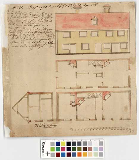
Click for high resolution
That’s the same year as this map (28MB, though I love it when I get to download stuff at “2400 KB/s” — I’m definitely getting my money’s worth as a tax payer around here:-)
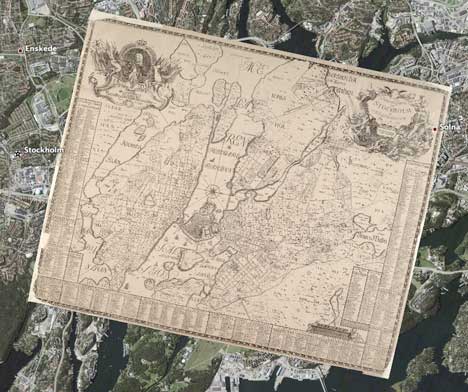
These documents will be georeferenced, so you can zoom in on a historical map in Google Earth and get links to drawings and outlines for historical buildings there.
So where am I going with this? These drawings and architectural plans would actually be an amazing resource for a virtual reconstruction of historic Stockholm, built with SketchUp. The drawings could provide both shape and texture to 3D buildings, while the maps pinpoint location. You could then fly around an accurate 3D rendition of Stockholm as it was documented hundreds of years ago!
And if the conversion tools mature, as I have no doubt they will, you could soon port all this work into Second Life, and then walk around in it, wearing nothing but 18th century fashions.
That’s too cool for it not to happen somehow…
[Update 0:24 UTC: Forgot to mention that Swedes are very good at this kind of geospatial enhancement of historical databases. Be sure to also read this story from a few months ago about the geospatial database of Swedish historical monuments.]
Microsoft’s Sync car OS comes without GPS Navigation!
Two weeks ago, the WSJ pre-announced Sync, Microsoft’s dashboard OS that will make it into new Ford models later in 2007. The article mentioned a navigation system, so I had some fun speculating whether that meant we might soon find Virtual Earth in Ford dashboards, much like Google Earth likely will soon be in VW dashboards.
 I lost focus on CES announcements this week, distracted by another gadget at MacWorld, but now I’ve had a chance to plug back into Sync. I had to scan many an article to find any reference at all to GPS navigation in relation to Sync; the only reference I eventually found is to how Sync doesn’t have it. Extreme Tech’s article:
Sync is essentially the Microsoft Blue & Me product announced a year ago with Fiat and much matured. Fiat had a one-year global exclusive; now Ford has a year’s exclusive in the U.S. market.
Sync is more robust, Microsoft says, particularly the near-universal support for virtually all phones and music players. But it’s missing the GPS navigation feature. With Blue & Me cars, the user can request navigation instructions using the cellphone. A remote computer parses the request, confirms it’s the address or business you want, then downloads navigation instructions and rudimentary maps, navigating via arrows. The route instructions are spoken through the car speakers; the map information appears on the radio faceplate. Those features, including the navigation capability, cost about the Euro equivalent of $300, thus our belief Sync needs to be in the $250-or-under range.
All Sync’s demo site shows is that Sync will let you voice control your phone, Zune or iPod — in your best French if you wish. Yeah, that’s much more pressing than GPS-based dashboard navigation. Tom Tom and Garmin need not worry about Microsoft.
Of course, I was also disappointed to find no GPS in the iPhone — probably because battery life already isn’t all that hot without it. So for now, my next phone remains the Nokia N95, which will be the nec plus ultra for georeferenced photo and video blogging, something which I plan to do a lot more of when I move to Cairo in March for a few months.
Links: Google Earth fights crime in São Paolo, the skip zone, Stockholm maps, Shape2Earth, GeoRuby, NMF schema
Why-oh-why is there never a “medium news day”? Many of the following entries deserve a post all by themselves, but unfortunately it is now or never:
- You couldn’t make this up: São Paolo police fight crime with Google Earth, catching the notorious criminal known as “Matador” by triangulating his cell phone signals to his hiding place. (Via Blog do Prof. Palazzo)
- Ever heard of the Skip Zone? I hadn’t but that’s because I’m not a ham radio operator. Skip zones are a real nuisance, it turns out. The Squid Zone explains why using Google Earth. Great use of Google Earth for science education.
- Stockholm’s city archives have made available a dozen historical maps of the city, from 1625 to 1922, as KMZ overlays. Be careful, some of the maps are gigantic, clocking in at 50+MB per download, but amazingly, Google Earth is not showing any laggy behaviour as a result.
- Press release:
Microsoft Corp. today announced that it will begin to update the Virtual Earth online mapping platform with new, more detailed U.S. imagery under an agreement with GlobeXplorer LLC
Wait a minute, isn’t that the same company that was bought by DigitalGlobe only yesterday? And didn’t DigitalGlobe strike an exclusive licensing deal for its imagery on the internet with Google just six months ago? That’s pretty clever of DigitalGlobe to end up serving maps to MSFT after striking such an “exclusive” deal:-) (Via James Fee GIS Blog)
- Landcraft is a gorgeous timewaster (Via The Earth is Square)
- Tim Beerman’s Shape2Earth is now live. Shape2Earth’s is a plugin for the open source MapWindow GIS viewer, so you don’t need to buy anything else to convert Shapefiles to KML. Shape2Earth costs $30, and there is a free evaluation mode, so you can test this without risk. For more info, check out the user’s manual.
- The Sandio/Visiontek XG6 3D mouse, previously blogged here, is being shown at CES, and now has a price: $80. It is billed as gamer’s mouse that is also compatible with Google Earth.
- John Hanke’s post on the official Google Blog announcing Google Earth 4, SketchUp 6, and the revamped 3D Warehouse.
- France’s Guilhem Vellut, also known as Pochi Superstar, has been building GeoRuby (RubyForge page) which is (as far as I understand it) a library of geospatial database commands for SQL using the Ruby programming language. The latest version, 1.1.1, now supports output as GeoRSS and KML.
- The schema file description (XSD) of ArcGIS Explorer’s native XML file format, NMF. (Via Pochi Superstar’s Del.icio.us links)
- Google Maps API Blog, that’s a very good point: Expose the geospatial database that propels your mapping site as a KML file, add that file to Google Sitemap, and sit back as as people find the site via Google Searches for locations. And if you’ve done all that work, why not just add KML network links as a feature for the end user… (Via Mikel Maron’s del.icio.us links)
Google Earth 4: The hidden updates
A member of the Google Earth team writes in:
Here are a few database details you’ve not yet noticed…
- US Congress information has been updated to reflect the 110th Congress (Senators and Representatives) who took office on January 4th.
- Updated content from the GeoWeb layer data sources (example, more than double the number of Panoramio photos)
- Updates to other data layers (Volcanoes, ESA images, Tracks4Africa, etc.)
- Updates to GEC [Google Earth Community] content to capture latest posts there.
- …and as always, lots of subtle changes to refine both client at data.
it’s always good to have somebody looking over my shoulder…:-)
Apple iPhone does Google Maps. Could Google Earth follow?
[Update 2009-10-27: Google Earth for iPhone is here! Read the story]
Steve Jobs has just been demoing the iPhone for the past hour and there is a puddle of drool forming on the floor here. I’ve been following live Engadget’s coverage and that of MacRumors. Jobs has just shown Google Maps as an application for the iPhone on what looks to be an incredibly sharp screen. Here’s a photo from Engadget’s coverage:
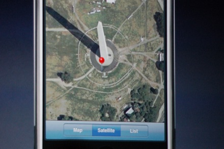
The only question on my mind right now (other than How am I going to be the first in Sweden to get my grubby paws on an iPhone) is this: The iPhone runs OS X. Will it run Google Earth? Perhaps with a little tweaking?
[Update 19:42 UTC: Check out the very impressive Maps on iPhone demo here.]