- DestinSharks.com has turned a global oceanic sensor web into a great KML network link, displaying hourly updated weather readings from ships participating in the NOAA/WMO Voluntary Observing Ship (VOS) program.
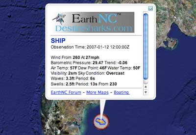
Ship locations show color-coded directional icons depicting wind speed and visibility, with more context if you hover or click — and all observations are time-stamped, so you can navigate through the past 24 hours.
- New blog: Free Geographic Information Tools. Writes its author, Leszek Pawlowicz, in an email:
The first series of posts will mainly cover how to meet or beat most of the capabilities of Google Earth Plus (GPS import and export, spreadsheet import, address geocoding and real-time tracking) using free or cheap software.
Welcome to the sandbox, Leszek.
- Andrew Hudson-Smith tries SketchUp’s Photo Match perspective tool for urban modelling. The verdict: “It significantly speeds up the modelling process for urban visualisation.” The tutorial movies on the Sketchup help site are well worth watching to get an idea of what Photo Match entails.
- The Earth is Square shows off a tool in the forthcoming NASA World Wind that lets you get terrain profile cross-sections for any great-circle line you care to draw. I like. I also like topo maps for Southern Africa.