3D charting: Google Earth or Second Life?

Adam Schneider, who is behind the GPS Visualizer web app, has been experimenting with ways of using Google Earth to visualize non-geospatial data. He writes:

schneiderchart.jpg

I wanted to create a graph of some data that has FOUR dimensions, so I did it in Google Earth.

The data in question is a list — that someone else compiled — of discs used in the sport of disc golf; the four dimensions are:

  1. “High-Speed Stability” (how much a disc resists turning to the right when thrown with a lot of speed)
  2. “Low-Speed Stability” (how hard a disc tries to fade left as it slows down)
  3. “Range” (how far the disc can be thrown)
  4. “Power Requirement” (how strong of an arm you need to get the disc to do what it’s intended to do)

I used Excel to translate HSS and LSS to latitude and longitude (in the middle of the Pacific Ocean!), used absolute altitude to represent the Power Requirement, and then used GPS Visualizer to colorize the points by Range. Then I created a set of axes in Illustrator and added it as an image overlay.

Download the KMZ file

I suppose if one wanted a FIFTH dimension, you could use time. (If I had translated Power Requirement to time instead of altitude, you could use the timeline to quickly filter out discs on either end of the scale.)

And, it just occurred to me, you could resize the points for a sixth dimension.Now that’s getting to be a bit much. :)

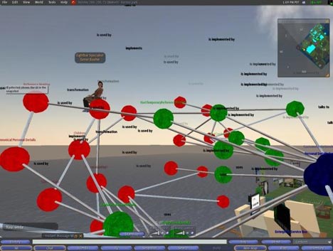
KML’s ability to describe and reference objects in three dimensions clearly lends itself to data visualization experiments of this kind. But so does the Second Life client — IBM has developed some cool examples on its islands, as documented on their Second Life developers’ blog:

107148.jpg

So what are the advantages and disadvantages of each? These are the ones I came up with while enjoying free wifi at Budapest airport:

Advantages of Second Life: The client is free to use, even for business. Objects can be scripted, so they can be made to interact with each other, or rearranged according to user inputs. 3D charts can also be viewed and commented on communally inside the application — and you can also point out interesting elements by physically going to the datapoint in questions and flagging it; others will see you do it.

Advantages for Google Earth: You can publish your chart as KML for free — in Second Life, you need to buy or rent property before you get the ability to build on it, and even then the rules may be restrictive. (You can practice in a “sand box” in Second Life, but nothing there is permanent, so you can’t direct people to it via a permalink.) A KML/KMZ 3D chart object is also easily portable, in that it is a file which you can email. In Second Life, by contrast, objects exist in-world only, on Linden Lab’s servers, so you have to direct people there via a URL (“slurl”).

When it comes to static data objects,, you currently have to build these manually in Second Life — whereas it is relatively straightforward to convert a spreadsheet of data into KML via XSLT, as EditGrid does, because you’re mainly doing text manipulation. Nothing equivalent exists for Second Life at the moment.

When it comes to dynamic data updates, both applications lets you use information on the web to update chart objects: In Google Earth, it’s doable via a network link, though then the conversion to KML has to be done server-side, while in Second Life, URLs can be called from within the scripting language and then massaged accordingly. In both cases, you need to write the data manipulation code beforehand and serve it from your own server (in Google Earth) or via objects on your own property (in Second Life).

Both applications will continue to improve, and may start adopting some of each other’s features, but there are also other applications being developed that may be aimed more specifically at 3D visualizations for business, such as Ogoglio. So this is a very interesting space to watch.

(Interestingly, Second Life has also seen a weather visualization experiment — taking advantage of SL’s scripting abilities to convert coordinate data into SL’s Cartesian coordinate system.)

Links: HoudahGeo, EarthNC Plus, Google GeoDay report

  • I’m in Budapest for the weekend so I can’t really give this the attention it deserves, but HoudahGeo (beta) is a new photo georeferencing software app for the Mac, and at first glance it looks really gorgeous and easy to use, with Google Maps and Earth integration. I will test this on my photographer-dad tomorrow while in Belgium and report back. (Via tuaw.com)
  • Google Earth Blog has details on the release of EarthNC Plus, US National Oceanic and Atmospheric Administration (NOAA) marine charts turned into KML files on CD, produced by DestinSharks.
  • Google Blogoscoped has a report about Google GeoDay in the Netherlands.

Google’s New Orleans update gets US govt scrutiny

Catching up on the news with AP:

House panel: Why did Google ‘airbrush history?’

NEW ORLEANS, Louisiana (AP) — Google’s replacement of post-Hurricane Katrina satellite imagery on its map portal with images of the region before the storm does a “great injustice” to the storm’s victims, a congressional subcommittee said.

Whereas in some parts of the world, governments fret that Google is revealing too much of their sovereign lands, in the United States government frets that Google is revealing too little. Am I the only one who thinks this is highly ironic? I feel compelled to add that this is not an April Fool’s post.

While I applaud and agree with the sentiment that newer data is better than older data, certainly after a natural disaster or war, throwing the US House Committee on Science and Technology subcommittee on investigations and oversight (what a mouthful) at this is ridiculous. It should be none of anybody’s business other than Google’s when it comes to prioritizing where it spends its money on updates. Governments are in the wrong when they try to censor imagery, and they are in the wrong when they try to compel a private company to provide a specific service.

I give Google a hard time when it acquiesces to censorship attempts, and I’d give them a hard time if I’d think they were in cahoots with New Orleans to make the place look more attractive for some kind of financial benefit, but I think that this particular conspiracy theory is among the sillier ones I’ve heard of late.

Meanwhile, Google has apparently gone into damage control mode, releasing a statement which you can read below the fold.

One final comment: This should put to rest any doubt, if there still was any, that Google’s geospatial imagery database has become the global default reference. When something is this universally useful, governments tend to want a piece of it.

Continue reading Google’s New Orleans update gets US govt scrutiny

Links: SketchUp co-founder leaves Google, more on GeoGlobe

  • SketchUp co-founder Brad Schell has decided to leave Google, reports AECNews. The parting seems to be most amicable.
  • Converjed has more about GeoGlobe, the Second Life/KML mashup reported on a few days ago.
  • Oxford’s city government has virtually modelled a part of the city with SketchUp, and will release it to the public “once it’s to a completed point where we’re satisfied with it,” reports the Oxford Press.
  • TechCrunch’s rumor about Google having acquired street-level image collector Vutool is now two days old, and still there’s no confirmation from any party that it’s true. I wonder what Arrington meant when he wrote: “There are strong indications that Google is the acquiror.” That doesn’t sound like a sure thing, and remember, TechCrunch also got the Google Earth Metaverse rumor wrong. So we’ll just have to wait this out.

Malaysia won’t ask Google to blur satellite imagery

Reason prevails in Malaysia. Reports the New Straits Times:

MALAYSIA will not ask Google Earth to blur images of the country’s military facilities to avoid terrorist attacks. Defence Minister Datuk Seri Najib Razak said doing so would indirectly pin-point their location anyway.

“The difference in, or lack of, pixelation of images of the military facilities compared to the surrounding areas will make it easy for visual identification.” In his written reply to Datuk Dr James Dawos Mamit (BN-Mambong), Najib said the images were provided worldwide commercially.

HeyWhatsThat goes global

HeyWhaysThat, the panorama generator for Google Maps and Earth I raved about two weeks ago, now does most of the rest of the world as well.

For example, here’s the view from the top of the Matterhorn, and here’s the view from Monte salvatore, near Lugano, from where you can see the Matterhorn, as confirmed by me last year and HeyWhatsThat today.

But there are even more esoteric uses of HeyWhatsThat. It’s forbidden to climb the Pyramids of Giza, but at least you can now create your own virtual panorama. Check it out in Google Earth to get an idea of just how breathtaking the view must be:

gizaview.jpg

Below the fold, an email with more details, tips and information from HeyWhatsThat’s Michael Kosowsky.

Continue reading HeyWhatsThat goes global

Shorts: Photoshop to do KMZ; Earth Addresser; UTMFlyer

  • The extended (i.e. expensive) version of the soon-to-be-launched Adobe PhotoShop CS3 lets you “import, view and interact” with 3D content, including Collada and KMZ files — presumably those containing exported SketchUp content. I’m not sure what this means, but Adobe has some more info (and annoying voice content).
  • Earth Addresser by Steffen Kamp and Sven-S. Porst is a very simple freeware application for the Mac that does one thing well: It turns all the addresses of your contacts in your Address Book into a KML file. Screenshot here.
  • From the Competition is Good For You department: Virtual Earth also updated its imagery yesterday: There is heaps of new Birds Eye coverage for European cities, including the parental home in Antwerp. (Via RXBBX Blog.)
  • The Map Room points to a post on Valleywag which alludes to a rumored list of 15 countries where Google Earth is banned. I have my suspicions: Bahrain tried it, Morocco may have, but no other country’s ever been in the blogs for banning just Google Earth. Of course, some countries heavily restrict access to large tranches of the web, like North Korea and China, so I’m not sure if that counts, though even China seems not to have blocked access to Google Earth, despite some speculation that it had.
  • Free GeoTools points to this little piece of beta freeware for the PC: UTMFlyer lets you enter UTM coordinates, then flies you there in Google Earth. it will also convert between “normal” coordinates and UTM. (Via The Map Room)
  • Squio blog is blogging Google’s Geodays in the Netherlands, now ongoing (mainly in English).