Satellite imagery helping to find new Egyptian sites to dig

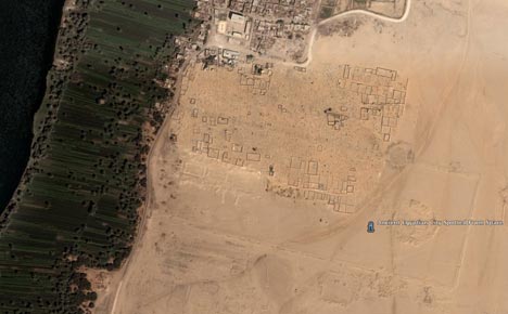
A LiveScience article relates how satellite imagery is being used in Egypt to find promising new sites to excavate. Egyptology Blog locates one place mentioned in the article (here it is in Google Maps) — a settlement from 400 AD on top of a much older temple dedicated to Akhenaten, the pharaoh who came up with monotheism and moved his capital to modern-day Amarna, just to the north of the site.

amarna.jpg

Turn on the National Geographic layer in Google Earth to see links to an article from 2001 about the region. And if you turn on the Google Earth Community layer — an unparalleled repository of raw geographical annotation — you’l find this link to an overlay of the region.

(I’m pretty sure that the settlement featured in the article was already discovered and excavated, so this is not a case of looking at Google’s own Digital Globe imagery and going “what, you didn’t know that was there??” But it certainly takes an archaeologist familiar with the region to know what’s been documented and what hasn’t.)

One thing is certain: These “tells” aren’t time sensitive, so the sudden abundance of cheap high resolution imagery, even if it’s 18 months old, has made satellite-based archaeological discovery much cheaper and accessible.

Previous articles in this vein:

Google helps discover Roman villa

Archaeologists dig Google Earth

Google Earth craterfest: New craters look promising

Gombe Chimp blog revamps with help from Earthwatchr

gombenew.jpg

Two related announcements of note: 1) The pioneering and Google Earth-featured Gombe Chimp Blog gets a major upgrade (including a design revamp and a change of address), and now uses 2) Earthwatchr, a new open-source geosavvy content management backend that uses Google Maps to georeference posts and which outputs content both as HTML with ready-made Google Maps and as KML.

Earthwatchr beta source code will be available July 15, 2007, according to the site. Bryce Tugwell and Nick Novitski are the people behind this. Nick blogs his involvement in the development of Earthwatchr on That Bright Instrument, highlighting some of the cool features:

If you go to the [Gombe Chimp Blog], you can see Earthwatchr integrates google maps, google earth, and your website into a single experience. Please feel free to try out the geo-referenced comment feature: Replies and comments that possess spatial information, just like the posts themselves

Bryce let me have a look at the CMS: Here’s how you georeference the post — you can even add a path:

earthwatchr.jpg

There are also options for defining the view in Google Earth. Here’s some of them:

ewperspect.jpg

Earthwatchr is written in ASP, but Bryce writes in an email:

We will be posting a forum for users to post questions suggestions and new versions, perhaps some other users will decide to jump in and start a PHP version.

There are a couple of other geosavvy CMSes out there, but Earthwatchr is the only one I am aware of that uses Google Maps in the back-end to georeference posts. I’m guessing most mainstream blog CMSes will have this feature in a couple of years. What I’m also looking forward to is GeoRSS support.

Which map will the One Laptop Per Children use?

I played hooky on some of the ISDE5 conference proceedings, only to find a pretty green One Laptop Per Child (OLPC) computer sitting all by itself in a conference room, which drew me to it like a moth to a flame. It turns out that an ISDE volunteer, Ed Cherlin, had one on loan from Google to show off to people here. I was smitten.

20070607021.jpg

What did I end up doing with it? Check today’s web mapping tools for compatibility with the OLPC browser, obviously. How did they fare?

Google Maps passed with flying colors. It looked just like how it looks on my Firefox:

20070607021l.jpg

Microsoft Virtual Earth? Not so much. It wasn’t possible to get it to show a map, though I was welcome to search as much as I wanted:

20070607022.jpg

Yahoo! Maps? The new beta didn’t manage to show a map, but presumably that’s why they call it a beta:

20070607023.jpg

The classic Yahoo! Maps worked without a hitch:

20070607024.jpg

The upshot? Even if you can’t get Google Earth on the OLPC, you will definitely be able to visualize KML files, as you can load these up via Google Maps. Good to see, too, that Google has OLPCs to play with, test for compatibility and loan out to conferences to help evangelize these. Are there OLPCs on Microsoft’s and Yahoo!’s campuses?

Links: Beirut imagery, Google Earth Gallery

  • The Google Sightseeing blog notices that Google’s latest update now has imagery of Beirut that shows the aftermath of last summer’s war. The post also mentions how this data was intended for inclusion then, but I think that in the end, the nature of the material simply proved too controversial and simply could not be presented neutrally while such a war was still raging.
  • Google Earth’s site has a new page that highlights particularly helpful or impressive KML layers: The Google Earth Gallery. Currently highlighted: the HMS Endurance’s trip to Antarctica, and another take on Darfur, this one with a lot if site-specific information about individual villages. Excitingly, a lot of this content is tagged with categories, so expect plenty more of such “best of” content. It’s a 3D Warehouse for geospatial datasets, if you will. (Google’s announcement)
  • BeLight’s Live Interior 3D 1.1 gains the ability to import SketchUp content. Coming at the tail end of a slew of similar announcements by 3D authoring tool developers, it seems that in the CAD world, SketchUp’s native file format is attaining a prominence not unlike what KML has achieved in the GIS world.
  • The Mediterranean Archaeology Geographic Information System (MAGIS) project looks like it will soon be available as KML.
  • Roderic Page’s iPhylo blog writes about his own recent efforts at “playing with Google Earth as a phylogeny viewer”. (Previous posts on phylogenetics: here, here and here).
  • Arounder.com does not currently have a Google Earth layer associated with it, but it is a wonderfully executed amalgam of 360-degree panorama imagery, soundscapes, Google Maps, and textual guided tours of some of the most interesting cities in Europe, but also of places in the US and even of missions to the Moon. Worth a visit.

Amnesty International’s ‘Eyes on Darfur’ launches

eod.jpg

Amnesty International today launches Eyes on Darfur, a project whose major component is a website that focuses on 12 specific Darfur villages, the intention being to depict the ongoing tragedy on a human scale as a way of motivating visitors to take action:

Eyes On Darfur also breaks new ground in protecting human rights by allowing people around the world to literally “watch over” and protect twelve intact, but highly vulnerable, villages using commercially available satellite imagery.

In practice, this means that a Flash application (why-oh-why break the browser’s back button and lock the satellite imagery into a proprietary format?) makes satellite imagery available to visitors that is just weeks or months old, and often also photos from before attacks.

Every initiative on Darfur is a worthy initiative. I would love, however, for this weeks-old data from Darfur to be made available in an open, georeferenced formats, in time series and on a much wider scale, so that GIS volunteers really can monitor villages for change. I’d gladly “adopt” one of the 1,600 villages and monitor it, given the data. I also think Flash is not the best visualization tool for geospatial data — there is not the natural flexibility with layers and such that lets this content be truly compelling and immersive:

drfurvillages.jpg

The dots show destroyed structures, but cover those said structures, and you can’t take them off. So I hope this new data also makes it into Google Earth.

India govt continues its quest to censor Google’s imagery

India’s The Economic Times reports that, not surprisingly, the Indian government is attempting to use the news of the JFK plotters’ affinity for Google Earth as a planning tool as a leveraging tool in their own attempts to censor Google Earth imagery for India.

A high-level meeting was today held in Union home ministry to frame a concrete strategy to tackle the possible threat posed by Google Earth, which provides easy access to satellite imagery of vital installations across the country.

There seems to be mistaken assumption (or a deliberate misrepresentation) on the part of the Indian government that:

Google had last year assured New Delhi that it would remove high-resolution images of vital installations across India but security agencies still fear that militant groups could use this facility to create terror.

That has been categorically denied by Google. Another point not addressed: There are plenty of sources other than Google for this kind of content, including the exact same content.

Links: Photoshop plugin for 3D Warehouse, Magnalox does embedded live tracking

I’m on my way to San Francisco to attend ISDE5, but the layover at Newark is proving to be a perfect interlude for blogging:

  • Adobe Photoshop CS3 Extended gets a free plugin that lets you search Google 3D Warehouse for content, download it and edit from within the program. Download here.
  • Nokia Sports Tracker gets updated to version 1.49, with some improvements to the KML export function.
  • Did Google Earth help NYC terrorists? “The answer is an unequivocal no.” (Regarding terminology in common use right now: If you plan on murdering someone but you are caught before you do so, are you a murderer? If you plan a terrorist act but are caught before you execute your plan, are you a terrorist? When everybody is a terrorist, nobody is.)
  • Regarding the censorship of French imagery: The Map Room and others do remind us that this imagery is censored at the source, not by Google (it’s good to repeat this) but one thing Google still can do is choose not to buy Spot Image’s censored datasets. DigitalGlobe’s data isn’t censored over France. Is it a question of cost? Is France giving Google an offer that it can’t refuse? (I’m asking, these aren’t rhetorical questions hinting at a conspiracy.)
  • Magnalox, a site for storing and publishing GPS tracks, has been announcing some cool new features: First came free live tracking for GPS-enabled mobile phones (both Windows Mobile and Symbian S60) to Google Maps and Earth (though you may have to buy the tracking software), then came the ability to embed the Google Maps tracker on any site, and today also a Mac OS X dashboard widget version of the Google Maps tracker. Here’s a live embedded tracker for a person riding his motorcycle through the Alps (and who is okay with publicizing the data):

[Removed.] Hmm, looks like that particular implementation of doesn’t play nice with Google Adsense code. Here is the link instead.