- Atom for KML: Very interesting post by Sean Gillies: Atompub, KML and Google Earth. Just as you can today use the Atom publishing protocol to post and edit entries in a blog, Sean suggests that soon we may be using it (or something similar) to post and edit content in a KML file. That would make parallel publishing/updating to not just HTML and RSS but also KML very easy. I like it!
- Coloring maps: I’ve seen this mentioned on some geoblogs but hadn’t tried it until now. Zonum’s ColorIt, which first offers you a set of map boundary data for subdivisions of a country or state (globally), then colors it, and finally lets you export the data as KML (where you can play with transparency), is actually really cool:
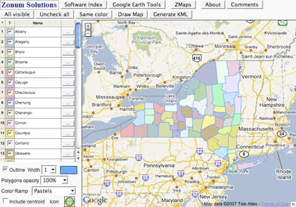
But Zonum has more Google Earth related stuff on his website, all of it under the radar until now (at least my radar): There is a whole collection of free small converters available, for example for turning an Excel spreadsheet into KML, KML into a Shapefile (and back), finding the bounding box coordinates, KML to AutoCAD DXF and a lot more. Check it out to see if there is a tool there for you.
- Bikemap.de is a German-language community site for bike routes, with nice design, height data, embeddable maps, and exporting as GPX and KML. It uses the new MyMaps tools for editing and adding routes. Definitely worth a look. (Via Teddy Krieger)
- Sketchup campus competition downunder: After the US SketchUp campus building competition, there’s one for New Zealand and Australia.
- Immersive US cities: Launching later this year, EveryScape, which seems to be a US counterpart to urban panorama sites Arounder and 360 Cities, though with a “mentored” user-generated component. EveryScape also has in-picture links to more info and to nearby locations — it’s just like a real-life verson of Myst:-) No word if there will be a overlay for Google Earth. (Via O’Reilly Radar)
- UK GE imagery update: Google’s latest dataset update erases some recently built infrastructure at UK’s RAF Fairford air base, where B2 bombers are stationed, according to Secret Bases, a UK military site. Apparently, older data has replaced newer data. Is it a conspiracy? I doubt it, as only the southern edge of the base was updated, as part of a much bigger wedge of data.
- Hurricane tools: The GuiWeather site has updated their KML offerings in time for the US hurricane season.
- Pilot tools: Climb! for Mac is a pilot logbook. It’s database of airports now has links to the view in Google Earth. (Perhaps future versions will let you fly your track in Google Earth?) ($30)
- Virtual globe UI: OnomyLabs Geo-Explorer Table lets you tilt and rotate a table to navigate a virtual globe. It was demoed at the 2006 Where 2.0 and looks like fun:
Yearly Archives: 2007
Hamburg in 3D (finally)
Announced in January, but delivered in August, after Berlin and Dresden: Hamburg’s city center in 3D as part of the buildings layer in Google Earth. Was it worth the wait? It certainly looks good:
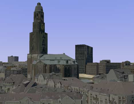
The models are credited to Cybercity AG, and the level of detail is impressive, especially when it comes to the nooks and crannies, though perhaps the colors look a bit washed out. You will also need a graphics card from the future — unless you are really close in, flying around Hamburg is done at extremely low fps… more like fpm, in fact. And because there is so much of it, expect to take some time for it to download.
If you read German, here’s more in the Hamburger Abendblatt. (Thanks Jan Wesbuer for the heads-up!)
Minimap: KML in Firefox’s sidebar
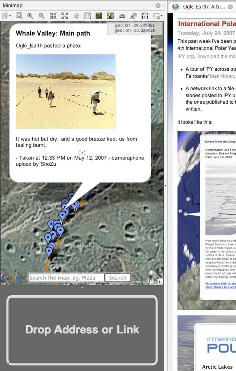
The Minimap plugin for Firefox, flagged a few weeks ago, has just received significantly improved KML support. Minimaps’ author Tony Farndon explains what’s been going on behind the scenes:
The Ogle Earth ‘crowd’ were kind enough to give me some feedback in relation to kml, and although still early days, I have vastly improved kml support including a stored list similar to the address list. The largely useless Map Tab has now become more of a fullscreen sidebar/2D GE to some extent as well. […] I use GE myself and have found the sidebar a useful tool to quickly check the contents of a kml before starting up and opening in GE.
FYI, the latest version on my website (version 0.1.4.6) has this improved handling. You can drag and drop or right-click and select ‘Open Link in Minimap’ for any kml link that ends in .kml, .kmz, =kml, Google MyMaps and keyhole kml links. (Any other kml links that DnD or right-click does not recognise can be opened manually from the sidebar ‘add kml’ toolbarbutton.)
I really like the idea of a sidebar giving you geospatial context whenever necessary to your everyday surfing experience — this way the map doesn’t become a dead-end in the surfing experience but instead a parallel experience. And Minimaps is a very robust implementation; I was able to get it to fetch polygons and even network links.
Any chance for GeoRSS savviness in the future, Tony? That could make the online newsfeed reading experience really compelling, as more and more feeds come to adopt the format.
SketchyPhysics
SketchyPhysics, a plugin for SketchUp (Windows only): I had no idea that adding a physics engine to SketchUp would be so easy (for us users), or produce such fun results:
That looks a lot smoother than Second Life’s basic physics engine, though perhaps not as scalable. Still, Google Earth + SketchUp + SketchyPhysics + avatars, and we’d be having heaps of metaversal fun. I don’t think it’ll happen anytime soon, but all the building blocks are getting there. (Via Think in Pictures, which has more YouTube videos to show you.)
Google to Mobile GMaps: No tiles for you
This sucks. Cristian Streng, developer of Mobile GMaps — the most feature-rich and robust mobile mapping application I know for J2ME-capable phones — has been sent a cease & desist letter from “Google Enforcement Team”. Google only lets you use mapping tiles from Google via the API. But the API is javascript-based. Mobile phones don’t do javascript. Ergo no Google Maps-based tools allowed for mobiles… unless you use Google’s own (barebones) application, of course.
Cristian has now complied with the letter of the law, if not the spirit, as he’s removed the Google Maps option from the most recent version but also made it possible for the end user to now define any base URL for a tile mapping service like Google’s. (This reminds me of online “crossword” games where you have to build your own Scrabble ™ board.) Hack the Day has the settings for getting Google Maps tiles in the new version if you are so inclined.
One highly ironic result: You can now only legally view KML files on your mobile on top of Yahoo Maps and Microsoft Live Local.
It’s Google’s tiles and they can of course set the terms however they want. But it’s undeniable we have ourselves a sub-optimal outcome here. Google should consider doing one or more of the following:
- Build a mobile mapping client that makes me want to switch from Mobile GMaps to Google Maps Mobile. (KML support? Live web tracking?)
- Hire Cristian Streng.
- Amend the API or their terms of use so that the mashup revolution can go mobile. Third parties need to be able to thrive on mobile platforms too.
That last point is very important. In an ideal world, people would simply start adopting more lenient mapping services for their mobile apps, and these then get the benefits of widespread adoption, but the real-world problem is that outside the US, high resolution satellite imagery by Google’s competitors is atrocious. In places like Egypt and elsewhere, Google’s imagery and maps are the only game in town.
In other Mobile GMaps news, KML output has been improved if you want to do live tracking with GMap Track. Simply point a KML network link to:
http://www.gmap-track.com/user.php?user=ogleearth&output=kml
You will get a placemark for your last location — and now also all the metadata that comes with it.
Links: MyGMMS; GE update details, real-time govt data?
- Embedded MyMaps: This is cool: Popular CMS WordPress has gotten an updated plugin that lets you display your Google MyMaps as embedded maps on your blog — MyGMMS. Here’s instructions.
- Google Update listed: Google (finally) lists the details of the past weekend’s dataset update. It’s official: All of Italy is at
40 pixels per meter resolution. Duh, at 2.5m per pixel, not 2.5cm. Entire list is below the fold. - Mega or giga? Government Computer News interviews Google Earth CTO Michael Jones. The article begins thus:
When it comes to getting new photographic equipment, most people would settle for buying a new camera. Not Google technologist Michael Jones — he has actually built his own four-megapixel digital camera.
GCN is off by a factor of a thousand when it comes to the pixelage of that camera. But the rest of the article is accurate, especially the bits by Michael Jones:-)
- Govt help for GE: Governments have for a while now been contributing static data to Google Earth’s dataset. Canada’s British Columbia province may become the first government entity to contribute real-time data such as roadworks information, reports The Vancouver Sun. (Via Peter Batty’s great writeup of the GeoWeb conference (part 1))
- ArcGIS Freed: You no longer need to register to download ESRI ArcGIS Explorer. Good move.
- Slow news day? The Daily Mail has the headline: Most detailed pictures of Earth ever seen. It must be a slow news day, as they meant Blue Marble images collated from MODIS. Beautiful it may be, but detailed?
- Free beer at last: The Wall Street Journal: Roofers are using Google Earth to calculate roof sizes and hence estimates. No mention by anyone that using Google Earth for work requires the $400/year Pro version. (Via Business Opportunities)
Continue reading Links: MyGMMS; GE update details, real-time govt data?
France’s Géoportail does 3D if you do Windows
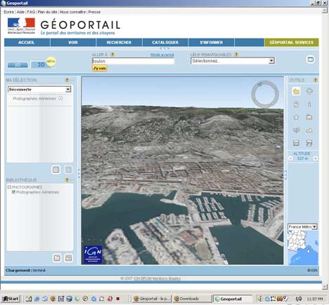
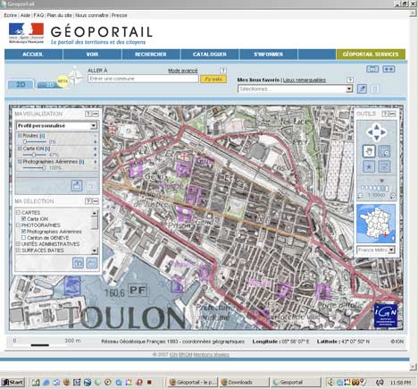
![]() Last summer, amid much fanfare and little server capacity, the France’s National Geographic Institute (IGN) released Géoportail, a 2D web mapping application that was (inaccurately) self-described as France’s answer to Google Earth. A 3D version was promised for 2007. It has now arrived.
Last summer, amid much fanfare and little server capacity, the France’s National Geographic Institute (IGN) released Géoportail, a 2D web mapping application that was (inaccurately) self-described as France’s answer to Google Earth. A 3D version was promised for 2007. It has now arrived.
Géoportail 3D is built upon Skyline Software’s Skyline Globe web browser plugin. Here’s comes my first complaint (what did you expect?): The plugin works on Windows 2000/XP/Vista only, which once again defeats the point of using a web browser to serve the data. (At least there are more Windows options available than the BBC’s XP-only iPlayer for BBC video.) [Update: Mac and Linux will be supported in January 2008, says IGN.] Second complaint: It is slow. On the plus side, the 3D version is clearly marked Beta — which means that these complaints are provisional:-)
Also no sign yet of the 3D buildings with facade mapping that was demoed back in April 2006. Meanwhile, Google Earth just got new high resolution imagery this past weekend for the French Riviera, Arles, Biarritz, Strasbourg, Grenoble, Angers, Amiens, Bourges, Clermont Ferrand, and the Loire River.
But some compliments are in order for the 2D version of Géoportail. Over the past year it has gotten some nifty features, including the ability to adjust the opacity of different mapping layers — for example having the imagery at 100% on the bottom and superimposing the map at 50% on top of it.
Still, the interactive mapping tools that Google MyMaps has made available over the past year makes Géoportail feel so, I don’t know, 2006? What IGN should have done, and what they still could do, is to make their mapping layers available to all comers, be it Google, Microsoft or NASA World Wind, and let them deal with the cut-throat competition of building compelling consumer mapping applications. That’s a completely separate skill from collecting and prepping geospatial data, which is what IGN specializes in, and what it should continue to focus on. IGN is not the French Google, and never will be. (Via Business Garden)