- Google Earth patent: ZDNet’s Russell Shaw unearths (ha) a recently published patent application by Google that details how Google Earth does what it does, particularly over on the server side. The application was filed April 25, 2006, and published Dec 6, 2007. I eagerly await Avi Bar-Zeev’s exposition of What It All Means.
- Outreach showcase: Google Earth Outreach gets its own showcase. (Via Google Lat Long blog)
- Daily geospace data as KML: Kyoto University’s Dagik. Wow. Quite a resource.
- GIS for development: Over at Global Knowledge 3 I ran into the Canadian developers of the ICT4D Atlas, an open-source map-and-database tool that lets you add georeferenced information (at the country and city level) and then perform basic analysis on it. The idea is to develop this into a fully fledged tool to help development projects. It’s a work in progress, but worth mentioning here in case others in this space might want to collaborate. (The developers are active on PPGIS.net, a mailing list for participatory GIS technologies that I was not previously aware of.)
- AGU: Google Earth Blog‘s Frank is covering AGU’s fall meeting.
Monthly Archives: December 2007
Earthmine: From stereo panoramas to an annotatable 3D city model
Earthmine is a competitor to Google Street View that was last blogged here in October. At the time, we noted that Earthmine turning automated city panoramas into an annotatable background canvas really is the state of the art. We even dared hope for some kind of vague far-off future where it is possible to “paint panoramas onto a very accurate 3D rendering of the world, so that every spot in the panorama and its corresponding coordinate on Earth become one.”
Fast forward 70 days. It would appear that Earthmine has done just that. Here is a video of their upcoming mapping product that is definitely worth watching:
The best part: They’ve licensed the technology behind software used by the Jet Propulsion Laboratory’s Mars Rover team which turns a series of stereo imagery into 3D terrain that mission control can then use to steer the rovers.
(Plenty of 3D Mars data sets made with this software were released to the public together with a viewer back in 2004, and it was easily the coolest thing my Mac did that year. That viewer, Maestro, and the datasets, are still available for download today. A must if you haven’t already. Earthmine, now that you have the technology, is it too much to wish for Marsmine? Just the bits where the rovers have been will do…:-)
Only bummer: Earthmine is Flash based, and Apple isn’t doing Flash on the iPhone.
Ordnance Survey OpenSpace: DOA
“UK’s Ordnance Survey has released (a closed alpha of) OpenSpace, an API for their maps! I’ve been wrong to criticize them for their paleogeographic ways when all along they were stealthily working to embrace us neos.”
That was my first impression when I read Ed Parsons’s announcement of the news. But Ed’s post also mentioned something about tile limits, and from the Guardian I learn that this API project is something “urged” onto the OS by the UK government’s Cabinet Office.
Time to dig a bit. And that’s when we go from the sublime to the ridiculous. From their FAQ:
1.4 How much data am I allowed to use?
OS OpenSpace allows your API key to access up to 30 000 tiles of data and up to 1 000 place name look-ups per day for free.5.4 My site gets a lot of traffic, what can I do?
Congratulations :! Contact us to talk about the different possibilities we may be able to offer you. If you are interested in commercialising your application, take a look at point 6.2 of the FAQs.
So let’s say I add an embedded OpenSpace map to a blog post on Ogle Earth that shows 9 tiles. That should last me about the first 12 hours of every day. Sorry late-rising Californians, my quota is up! Should I add two such maps within 15 posts of each other, so that the front page of the blog displays a total of 18 squares, then Europe is out of luck too. Translation from OSese: Feel free to have a website that uses our maps, as long as it is obscure and unpopular.
Oh wait, there are licensing options available to those with sites that get “a lot of traffic”. But they are in dense legalese and for “businesses” and “value-added products” and “branded published products” with “royalty models” and “product schedules”… Dudes. I’m a blogger. WTF? Are we really all supposed to call you to find the price?
6.3 Can I have adverts like Google Ads on my website? (Is it only on the same page as the map or the whole site?)
No, please see the OS OpenSpace Developer Agreement (there can be no form of financial gain).6.4 Can I build an application for Facebook/MySpace/any other commercial website?
The application you build cannot result in any financial gain to you (the developer of the application), the user or any other party; please see the OS OpenSpace Developer Agreement.
Well, which is it? “Only on the same page as the map or on the whole site?” Does anyone know? Did someone copy-editing the FAQ write that and accidentally leave it in? Not that it matters; whatever the answer will be, this is so stupid and tone-deaf to the realities of Web 2.0 that I’m practically sputtering into my Malay gin & tonic. Pages and websites are artificial constructs in Web 2.0, as we’ve now all moved on to services aggregated from wherever they may originate. Do I really have to set up an ad-free www.NotOgleEarth.com and link to maps served from there as popups or iframes every time I want to use OpenSpace? Is OS not aware that advertising such as Google ads is ubiquitous on the blogs and hobby sites that the OpenSpace API is ostensibly for? For the overwhelming majority of bloggers — certainly those for whom 30,000 tiles per day is plenty — the ads at most help defray hosting costs, or else they are injected by web hosters to pay for free hosting services. Does the Ordnance Survey really think all these people are going to remove their Google ads from an entire site forever (or switch provider) if they once used OpenSpace to show their favorite route to work in a blog post now buried somewhere deep in the archives?
Mapperz, in his wonderfully efficient telegraphese style, has some further observations:
Note: Any Content you create using the Open Space API – Will not be yours, as it is ‘dervived’ from Ordance Survey Products. […]
No 1:25,000 (Explorer range) or 1:10,000 Rasters
OpenSpace will not be used by anyone. With the current restrictions it is dead on arrival. Perhaps that was the intention?
[Wait, the Developer Agreement has more:
2.6 The Website is provided for Use by private individuals strictly for the Purpose. You may not use the Website, the Ordnance Survey API or the Ordnance Survey Data or any part thereof in connection with any other purpose.
“Purpose” means any purpose or activity which (i) is not undertaken for Financial Gain; or (ii) does not result in Financial Gain to you or any User or any third party used by or in connection with you or any User; or (iii) is not connected to any company, partnership, sole trader or other business entity or professional body, any educational institution, or any central or local government or other public sector body; excluding for the express avoidance of doubt use in relation to any website that carries paid for advertising, and/or use by the afore-mentioned entities in their day to day activities, on their intranet or in connection with any display, promotion or advertising;
So does this mean that other people can link to the free popup OpenSpace maps on NotOgleEarth.com, but not me from OgleEarth.com? Or can you link to them only from sites that themselves do not have ads? What about sites that link to those? Is this a nefarious plot to rid the world of Google Ads by someone somewhere on the web linking to a single OpenSpace map?:-)]
Links: Antarctic sensor web coming, Google Sky Maps coming, KnitML
- International Polar Year news: It’s Ice Sheet Day today! Over on IPY.org, see participants in schools and at scientific institutions put a pin on a Google map to mark their participation. Meanwhile, news today that the Western Antarctic Ice Sheet is about to turn into a GPS-enabled sensor web. Greenland got sensors last summer — you can read the Greenland scientists’ blog entries on IPY.org, or you can download the IPY KML layer, zoom in on Greenland, and browse the blog geographically.
- Sky Maps coming soon: Being finalized in the Google Maps API Group: Google Sky’s data accessible via the Maps API, ready for embedding in your website.
- Murder in Melbourne: The Age writes:
Police are also hoping a Google Earth van, which has been tracking the suburb, can shed more light on the mystery.
It’s a long shot, but interesting lateral thinking. The Australian Associated Press article manages to mangle that news bit completely, though:
During forensic work at the crime scene on Wednesday, police were approached by a Google Earth operator who had been tracking the area by satellite for the past week.
Technoramuses make bad reporters these days. (Thanks, Michael)
- Earth nearly live: NASA’s OnEarth: Real-time updated global MODIS, as a KML file. “This layer is the most current, near-global image of the earth available.” (Via Mikel Maron)
- Multimap 2 MSFT: Microsoft by the UK’s Multimap for $50 mln, says the Times. Why? The Times intimates it’s a quick way for Virtual Earth to grow UK market share and get some local content.
- Flickr Places redux: Dan Catt elaborates on the thinking behind Flickr Places, and also links through to developer Kellan’s blog post.
- KnitML: Need a break from KML? Try KnitML.
The Earth from above, and a little bit from the side
Perhaps you’ve seen them outside London’s Natural History Museum last summer, or else in a Stockholm park, or in any number of places around the world — a travelling exhibit with stunning aerial photographs by Yann Arthus Bertrand. They’ve just now also shown up in Google Earth’s Global Awareness base layer — over 400 of them. Here’s the layer’s official site, and here is the blog announcement.
These photos provide hours’ worth of ogling pleasure. Until now, my main frustration with them was wondering where they were taken. No more. My new frustration with them is that they are georeferenced but not — we need to neologize here — geopositioned, by which I mean placed as overlays in Google Earth with the tilt and roll and zoom and field of view set just so, so that we can see exactly where the shot was taken from.
To show you what I mean, I took a photo of islands in a lake in Egypt’s Siwa oasis and positioned it in Google Earth so that when you fly into the picture, it “exactly” matches the view in Google Earth. Here is the KMZ file.

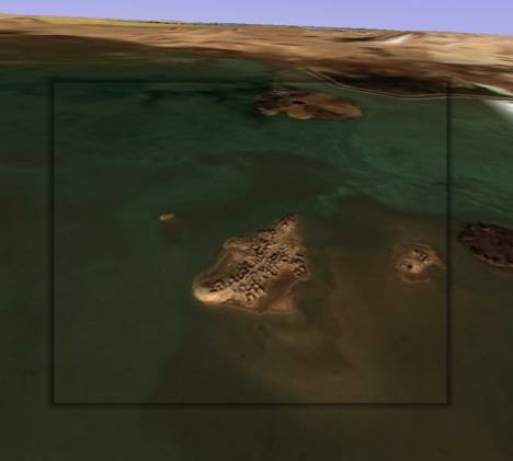
I confess it took me a long time to fidget with the controls to get that image to fit, but I was trying to make a point:-) Use the opacity slider to check the accuracy.
Geopositioning all photos is not really a scalable proposal — unless we all did one each, of course. Also, not all images lend themselves to this treatment — some are too close, others are of inconstant patterns such as drifting sandbanks.
Voila, yet another way Google Earth will quash your productivity — unless you can call it “research” for a blog post:-)
[Update 17:10 UTC: It just struck me that it would be very cool if there were to be a button in Google Earth that let you “paint” that photo from that perspective on top of the base layer, taking into account the height mesh (DEM) data and buildings, so that you could subsequently fly over it. I have no idea whether that would be a trivial feature to implement, but it is definitely where research projects are headed, and it would make for a great way to turn 2D images into 3D images. Google’s PhotoOverlay controls are obviously sufficient to accurately geoposition such a shot. Scalability remains the main problem, here, I think.]
Stone circle or just stoned? Swedish geodatabase to the rescue
Much as we’d love to find evidence of how astronomically savvy our ancestors were, sometimes a stone in the ground is just a stone in the ground. In Sweden this week, noted media hound and self-ascribed “archeoastronomer” Bob Lind announced to great media fanfare that he had found a 3,000-year old stone circle in Southern Sweden, complete with a “large phallus” pointing north.
Since a good false story reported uncritically is better than no story, much of the media went along, including the otherwise reliable The Local (tsk).
But then came the backlash of the experts. Martin Rundkvist, who writes the excellent Aardvarchaeology blog and who happens to be Swedish, led the charge. It turns out (Swedish) that the site is not new at all, but a stone-age cemetery that’s been known to archaeologists since the 1930s.
The one good thing to come out of this little media debacle is that it vindicates the pioneering work of Sweden’s Office of Antiquities when it comes to putting existing archaeological discoveries on the map. Their geographic database of historical monuments with KML output has been blogged on Ogle Earth before — for today’s story, I can use it to link to the precise location of the “find” that wasn’t: Ravlunda 169:1. From there, you can get KML, or else see it on Sweden’s two homegrown mapping sites, both of whom have the area in higher resolution than Google. (Eniro’s is the best).
Bob Lind could have checked that database to see if he wasn’t about to do something stupid, but that would have meant media obscurity. (For example, he could have looked at all the results for the local area, and then exported them to KML to see if the location of his “find” had a marker on it.)
Still, it’s good to know that the resource exists for real archaeologists.
EarthNC’s trip and route planner
I’ve just arrived in soggy Kuala Lumpur, tired and jet lagged after far too long in the purgatory that is Dubai airport. Tomorrow starts Global Knowledge Conference III, theme: Emerging People, Emerging Markets, Emerging Technologies. If I see any really cool new applications of GIS in the service of development, I will be sure to blog them. In the meantime, I am grateful to EarthNC for writing the rest of this post, so I can get some sleep:
EarthNC, Inc is pleased to announce the general availability of the EarthNC Google Earth Trip and Route Planner tool. The Trip and Route Planner provides a simple method to plan trips or routes using Google Earth and export them directly to Garmin USB GPS devices using the free Garmin Communicator plugin. For non-Garmin GPS devices, EarthNC provides a GPX file download option. With the release of the latest Garmin Communicator Plugin, the EarthNC Trip and Route Tool works on both Macintosh and Windows computers. [This is new!]
The EarthNC Trip and Route tool extends EarthNC’s novel ‘TakItWithMe’ Google Maps serviceto the 3D Google Earth platform. Trip planning and export is done with a few easy steps. To share trips, users can e-mail their trip folders to friends and family within Google Earth.
To help get users up and running quickly, EarthNC has produced a short video tutorial which demonstrates Google Earth trip and route creation, GPS export, and advanced tips:
The Trip and Route Tool is a free service of EarthNC.
(And if you’re still here, on a completely unrelated matter, also check out Google Maps API Blog’s Using the Chart API in KML for Quick Data Visualization.)