- S. Fjalar in Iceland proposes a class project for school: Use Google Earth imagery to make inspirational-style posters. See some of the results at the Artwork Earth Flickr group.
- West Virginia University’s GeoVirtual Laboratory plays with Virtual Reality Geographic Information Systems. Looks like the amalgamation of a couple things I’ve seen elsewhere on the web. (Via W. David Stephenson’s blog)
- Trulia real estate searches can now be saved as a live network link. Not entirely new, but very nicely implemented.
- Gaia gets rid of the Google Earth imagery, but continues developing, and gets its own project page on SourceForge. In case it wasn’t clear before, it’s for Linux.) The Earth is Square reports Gaia will get support for NASA World Wind imagery in its next release. Good to see.
- Talking of data: Over on OpenGeoData, Steve Coast announces that Yahoo! has agreed to let OpenStreetMap, the open source mapping project, use Yahoo! Maps’s satellite imagery. Rev Dan Catt cheers them on.
- Windguru gives wind conditions for windsurfers in many different spots. It now comes with a KML link. (Via 5 minutos)
- In the absence of Ogle Earth’s own review of ESRI ArcGIS Explorer (it’s coming, it’s just so damned busy right now), here are some others currently on the internets:
- Andrew Smith at Digitally Distributed Environments: “At first look ArcGIS Explorer is sadly disappointing with poor rendering of KML files and the ability to add data only if you are GIS literate.”
- Over on Dot Net Without a Net, Matt Priour reviews ArcGIS Explorer. Verdict: “This is going to be a niche product. If they can get the speed up to some reasonable level, I think it will be a really good one.”
- SpatialLink has initial impressions.
- Dave Bouwman does some Google vs. ESRI as opposed to Google Earth vs ESRI ArcGIS Explorer. Interestingly, Dave’s guestimates are remarkably close to mine, from last year.
- Geotagger, Craig Stanton’s Mac application that georeferences photos using Google Earth, is up to version 1.1.
- Google Earth is one of 5 nominated for “product of the year” by a Belgian marketing congress, in collaboration with the Standaard, one of Belgium’s largest newspapers. Also on the list: YouTube, the GPS device, podcasts, and digital TV. The GPS device already won last year. I guess you can win twice. (Via Belgeoblog)
- On Slashdot: A contributor discovers a Microsoft van collecting street-level imagery. Ready to be pasted at the street-level into Virtual Earth?
Monthly Archives: December 2006
Run ArcGIS Explorer on your Mac
Here’s a fun GIS party trick: Run ArcGIS Explorer as an application inside Mac OS X. While you’re at it, run SkylineGlobe as well: (Click on the image to enlarge)
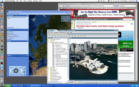
No, they didn’t just come out with Mac versions. Instead, Parallels came out with an update to its excellent Windows virtualization software for Mac. Two new features were added: The ability to run individual Windows applications just like any Mac application right in the OS X GUI, and the ability to use the Boot Camp partition with Parallels.
The first feature makes it look great, but what does the second feature mean? Apple already lets you boot into a separate partition on your Mac where you can run Window XP or Vista natively on the Intel Core Duo processor. Parallels, meanwhile, lets you create and run virtual disks with all kinds of Windows or Linux installs, and with virtually no speed penalty. With this latest update, Parallels now also lets you run your Boot Camp install from within Mac OS X, simultaneously. Before, you had to reboot if you wanted to use Boot Camp.
There is just one thing missing, still, in Parallels: 3D hardware acceleration. You do get full OpenGL and DirectX support in Boot Camp, so you can still reboot into it if you really want to access 3D functionality on your Mac, but that takes minutes. Parallels promises to add 3D hardware acceleration support in the coming months, but until then, here’s a rundown of compatibility for the current set of virtual globes.
Mac OS X:
Google Earth: Yes
NASA World Wind: No, but Java version promised
Microsoft Virtual Earth 3D: No
SkylineGlobe: No, but Mac version is promised
ESRI ArcGIS Explorer: No
Windows via Parallels in Mac OS X:
Google Earth: Yes (no 3D acceleration)
NASA World Wind: No, only runs with 3D hardware support
Microsoft Virtual Earth 3D: No, only runs with 3D hardware support
SkylineGlobe: Yes (no 3D acceleration)
ESRI ArcGIS Explorer: Yes (no 3D acceleration)
Windows in BootCamp:
Google Earth: Yes
NASA World Wind: Yes
Microsoft Virtual Earth 3D: Yes
SkylineGlobe: Yes
ESRI ArcGIS Explorer: Yes
So although NASA World Wind and Microsoft Virtual Earth 3D are currently not accessible via Parallels’ solution, this will change in a matter of months, either because the Java version of NASA World Wind has come out, or because Parallels adds 3D hardware support to their product.
None of this should mean that developers can stop developing for the Mac, of course. To use Parallels or Boot Camp with Windows, you need to own a copy of XP or Vista, and that’s not cheap.
Peeking at Hezbollah’s intelligence
Rip sends an interesting submission, and wonders if this is an example of Google Earth imagery being used as intelligence in warfare.
Northeast Intelligence Network has posted images of a Hezbollah command and control bunker captured by Israeli forces during the Lebanon war from last July. One of the images shows a wall montage of satellite imagery that is immediately recognizable as being of northern Israel:
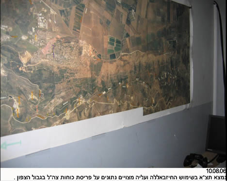
Rip wondered if that might be high resolution printouts from Google Earth. Well, there is a way to check:
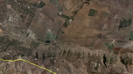
Notice there are a few clouds near the green fields in the center of the Google Earth image, so we can be sure Hezbollah’s intelligence does not come via Google Earth. Why should it — Iran has access to much better than 2-meters-per-pixel resolution, which is what is currently the highest resolution publicly available.
This also means, of course, that the argument against releasing high resolution imagery of Israel is weak. Those who want to do Israel harm already have access to the imagery, so why not release it to everyone, where it might do some good?
Belgeoblog interviews Belgian senator about censoring Google Earth
I’m shocked: Pascal Laureyn of Belgeoblog did some actual reporting, unlike the rest of us lazy bloggers, and interviewed Belgian senator Christine Defraigne, the member of the intelligence oversight committee who has been most vocal about her intention to censor aerial imagery of Belgium of the kind displayed in Google Earth.
Pascal writes a comprehensive article that looks at all the angles, including the effect of Google Earth on recent elections in Bahrain, the sanguine report on Google Earth in Belgium’s 2005 yearly intelligence assessment, and the current law in the Netherlands which allows the censoring of a list of sensitive sites from new imagery taken in Dutch airspace. Luckily, he writes in Dutch, which allows me to make myself useful by translating. Here are some of the bits with her responses in it:
Is our security brought into danger via Google Earth? Senator Christine Defraigne thinks so. “Those photos can be used by terrorist organizations,” the senator said in a telephone conversation with Belgeoblog.be. “That’s why I want that we get more strict in our approach.”
(She then comments on the sanguine 2005 end-of-year report, and says it is out of date, because it is based on “information from September 2004”. That doesn’t make any sense, though, as Google Earth was only introduced in June of 2005, and the report is clearly about Google Earth, not Keyhole.)
“State security has said that they’d rather work with combating the dangerous organizations directly, than to outline the potential danger of satellite photos. Of course we should combat those organizations, but I don’t think that’s enough and that we need to forbid the publication of some images,” says Christine Defraigne. […]
That’s why the senator is working on a new parliamentary report. “Maybe we should make a list with precise definitions that define which terrains may not be filmed or photographed. I’m not just thinking about our military terrains, but also our economic and scientific resources.” That report will be presented to parliament at the end of 2006 or early 2007. […]
Does it make any sense to try to stop the spreading of satellite and aerial imagery on the internet, given the exponential growth of such data? “We know it’s not easy,” says Defraigne, because the internet is global and diffuse. But we can’t give in just because everything is already on the internet; then we don’t protect anything any more. I find it essential that the government protects our terrains and buildings.”
Christine Defrainge admits that it will be difficult to impose sanctions on a company if it impinges on an eventual injunction against publishing images of certain areas. Certainly if the photos are made with a foreign satellite. “But I do not want to say that we should not take up our responsibility, even if it seems like a battle between David and Goliath.” […]
Senator Defraigne sees a solution along the Dutch model as being possible. “It’s like freedom of speech. It is a valuable right, but not an absolute right. Everybody must be able to say what they want, but for example slander and the denial of the holocaust are not allowed.”
“If it is about our national security, then we have to take measures. Other states have done that too. The right to information is important, but sometimes there are interests that are more important.”
Now I get to editorialize: I think Defraigne shows in this interview that she does not grasp how the Dutch law works (it’s on new imagery, not old), nor does she seem informed about the jurisdiction of national laws (airspace yes, space no). She does not seem familiar with the intelligence reports themselves. She also seems to think that Belgian law should have a say on what data server farms in the US can keep.
I also thinks she is cavalier about constraining free speech — she seems to think that holocaust denial laws are quite normal, when in fact most of the world (including the US) does not have them, because freedom of speech is also about protecting odious speech. That’s the whole point of it. Otherwise you have to decide what’s odious and what’s not, and who gets to decide that? I’m sure Defraigne would love to have a go.