Within days of Google adding a timeline to its Earth, four of the most impressive KML creation tools all have time tag support:
GPSVisualizer, Adam Schneider’s free but crazily feature-rich web-based converter of GPS data to KML (and much more besides), has added the option to “Add time stamps, if possible” to the upload form.
GPSBabel 1.3.1, an open source application for PC, Mac and Linux that takes GPS data and converts it to KML (and many other formats), “should build these tags for you automatically on download”, according to project lead Robert Lipe.
KMLer 1.4, Valery Hronusov’s ArcGIS 9 extension that gives you all kinds of options for exporting to KML (and importing from KML), can now also create <TimeSpan>,<TimeStamp> and <When> tags from ArcGIS layer attributes. Cost: $20-$50, depending on the version. There’s a free 7-day trial.
Arc2Earth, Brian Flood and his team’s ArcGIS 9 extension for exporting to (and importing from) KML, now has a comprehensive new time data tab that lets you fine-tune your time-enabled KML. Brian has posted a walkthrough of the functionality, including some examples, such as US states, time-stamped by date of accession. Cost: $100-$300, depending on the version. There’s a free 30-day trial.
Have I missed any? (It goes without saying that Google Earth Plus and Pro’s GPS importer also produce time stamps.)
Those early bug reports about external controllers in the PC version and the broken time functionality in the Mac version? Fixed! You can now download version 4.0.2091 beta for PC and version 4.0.2093 beta for the Mac. (Sorry, can’t verify Linux.) Here’s the delta report:
External controller now has a disable and is off by default
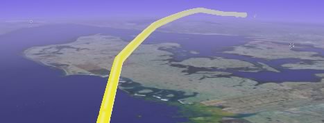
I wanted to try the new timeline functionality in Google Earth, so fortunately I had a tracklog lying around of a SAS flight I took between Brussels and Stockholm recently:
I massaged the data into KML (using grep in BBEdit), borrowing graphics from the whale shark example, to produce this KMZ file [Update: Fixed!]:
It’s a rudimentary first step, but it does work, as long as you’re not using the Mac version of the beta:-) (where a bug prevents time-tagged placemarks from showing up as intended.)
That was fast: Valery Hronusov’s KMLer, an ArcGIS extension for converting to and from KML, adds support for KML’s time tags in the latest version, 1.4. It also covers other KML 2.1 innovations.
Mikel Maron is back from the DR, just in time for a talk on time in GIS at FOSS4G2006 — and he’ll now have a client to do demos with: Google Earth. In fact, he already has a sample file up, posted to his blog.
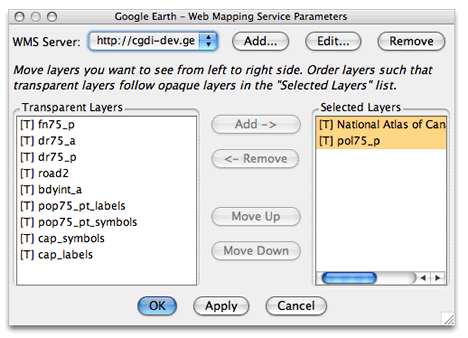
Where is that WMS capability? (What is WMS?) Zoom in on an area you’d like to see a WMS overlay for — say, a chunk of Canada. Then go to Add > Image Overlay. Select the Refresh tab, then click on WMS Parameters. This brings up a pop-up window that allows for some sophisticated fine-tuning of WMS content:
There are plenty of WMS servers preloaded for you to try right out of the box:
I chose a server with content for Canada, chose a few layers, and I got this:
In this particular case, every time I pause, the WMS server will be queried anew for an area approximately the size of the screen. Seamless.
[Update 10:19 UTC: Forgot to mention the coolest part: Once you have WMS-based image overlay, you can of course just right-click on it in the Places sidebar and save it or send it along to others. They in turn don’t have to know anything about WMS to be able to enjoy the same functionality you’ve just created.]
Relive memories by viewing and sharing your photos displayed on an interactive map in the exact locations where they were taken (works with United States addresses only).
An address-based georeferencing tool? Why? And why just US addresses? Sorry, but that’s not good enough. PSE5 should also map EXIF-based coordinate data, let you georeference globally by navigating to a spot visually, and allow you to export photos as EXIF or KML (much as Picasa 2.5 beta does). Maybe PSE5 does all these things, but if so they’re not telling.
The big picture here is that Picasa has a natural advantage when it comes to georeferencing because it can call on Google’s superior geospatial dataset. I think Adobe (and Apple with iPhoto) would do better to focus on a plugin system that lets us users choose (or build) their own georeferencing tool (and also photo sharing service). Use Flickr? Picasa Web albums? Panoramio? Why not edit photos in PSE5 but share them with a tool of choice? If Adobe is serious about entering the photo georeferencing and sharing game, they need to realize that there are better free solutions out there right now than what they’re advertising for $90.
Notes on the political, social and scientific impact of networked digital maps and geospatial imagery, with a special focus on Google Earth.