- Delaware’s Office of State Planning Coordination announces it now offers some of its GIS datasets as KMZ files, and links to them. They always have to be first, don’t they?
- If Microsoft acquires a company, and there is nobody there to blog it, did it really happen? Microsoft bought Vexcel a week ago and forgot to mention it, much as did with Geotango.
Like Geotango, Vexcel brings photogrammetric knowhow (definition of photogrammetry) to Microsoft’s toolbox. This suggests that Microsoft’s preferred route to populating its Virtual Earth will be via automated processes. Google, on the other hand, seems to be leaning towards user-contributed content, produced with tools like SketchUp.
- Speaking of Sketchup, @Last founder and now Googler Brad Schell responds to the open letter in the forum blogged previously.
- chtiGPS is a GPS tracker for PocketPCs and Smartphones, in French, with data for 7 European countries.
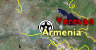 Turkish online paper Zaman contacts Google with a complaint about a missing border between Turkey and Armenia in Google Earth (and it’s true, it’s missing). The result: “Google, in a statement clarifying the issue to Zaman, accepted that some data in Google Earth is missing and/or incorrect.”