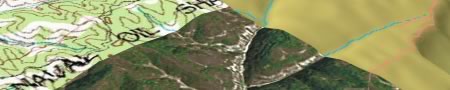
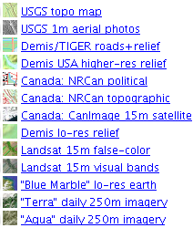
 For some time now, you’ve been able to use GPS Visualizer’s online forms to create custom-made topo maps and other overlays for Google Earth. Now Adam Schneider’s upped the ante again, creating a network link that lets you configure those overlays from within Google Earth. It’s a truly nifty piece of work — encompassing a wealth of mapping sources (see list) — and deserves to be a permanent fixture on any self-respecting Places panel.
Here’s how it works. When you find a view you’d like to enhance with an overlay, you refresh GPS Visualizer’s network link. This sends your position to Adam’s server, which in turn goes and finds out which maps are available for your location, chooses the best resolution depending on your height, and returns a list of links. Each link is in fact a pre-configured query for GPS Visualizer’s API. Click one, and you are taken to a web page where your personal overlay is ready for the taking.
Besides this being a fantastic resource, I particulary enjoy the implementation. I enjoy being able to move around an area while I download different overlays of the same place. Decloupling the view from the refresh makes the process of gathering overlays a lot more responsive. Automatic view-based refresh can make a network link feel too much like an overeager butler:-)
Oh, and the maps are huge. It made my aging G4 Mac PowerBook weep (the G5 had no problems). Adam recommends using the form for older systems, where you can ask for smaller overlays.