Adam Schneider keeps on adding features to GPS Visualizer. At this rate it will soon need its own O’Reilly hacks book. In the meantime, here are some of the latest additions:
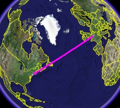 You can now draw great circle routes between airports on the calculators page. (The accompanying graphic is for the JFK-CDG route.) Writes Adam: “I added this feature because I’ve noticed a few people laboring to build files containing several great circle routes; this makes the process much easier.”
- You can set the default output of GPS Visualizer to KML files by appending “?format=googleearth” to GPS Visualizer pages, thus:
- Once your route is ready to download as a KML file, GPS Vizualizer now also offers you the ability to download an overlay with the recent local cloud cover for your view. This is a particularly slick touch.
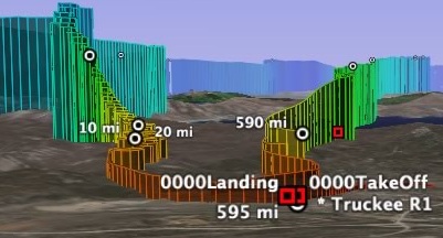
- On the Draw a map page, a new feature is the ability to draw extruded paths (i.e. with lines to the ground) which can then be color coded by altitude, leading to eye candy like this…
- You can now also add automatically generated distance markers to the paths drawn, specifying the interval on the form. This fuctions is now also available when you draw great circle routes.
- And I don’t know how old this is, but GPS Visualizer can colorize your data according to speed, course or distance even if your GPS data file doesn’t explicitly contain this information. GPS Visualizer will calculate it for you (though it does need time stamps, obvs.).
And if you ever get overwhelmed by the options, the documentation is extensive. GPS Visualizer is free, but you can help keep it so by donating to Paypal on the site.
Just thinking more broadly, for a moment: Which is better for GIS data manipulation of this kind — web applications or standalone applications? The latter are likely to be more powerful but also more expensive, while on the web you are more likely to find precisely what you need — and if you need it only once, pay for it only once.
And now that GIS browsers are free, does it really matter where the calculations take place? It would if the dataset becomes too large to download quickly, and I can see problems with scaling up resources (Adam’s server must be busy these days). But otherwise, surely GPS Visualizer is Google Earth’s best friend?