The Sierra Club presents a textbook case of how Google Earth can help illuminate public debate: The US government is proposing to sell 800,000 303,000 acres of public land managed by the Forest Service and Bureau of Land Management to fund rural schools. So what does Google Earth have to do with this?
The Administration has argued that the parcels proposed for sale are “non-vital” — scattered and isolated and therefore difficult to manage. Closer inspection reveals that a good many of the parcels are in fact in-holdings, many of them within roadless or scenic areas or containing old-growth forest. See for yourself: Users of Google Earth can download this kmz file to browse parcels that are proposed for sale across the country.
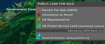
The KMZ is very nicely implemented, and indeed presents the data in a way that would be impossible to grasp in a written report or spreadsheet.
FYI
303,288 is what one savvy GE user actually calculated the acreage to be.
One man’s illumination is another man’s disinformation and/or propaganda…
303,000 is the correct amount of Land the Forest Service is currently saying is up for sale. This application is showing the lands that the Forest Service has proposed. the 800,000 figure is the combined BLM and USFS land…. This KMZ is not attempting to show all public land. I agree the way it was posted is a bit misleading.