A collection of short news items that is rather longer than I expected:
- GeoServer is up to version 1.3.3. The latest release has “some enhancements and fixes to the KML output format so it will work with the newer versions of Google Earth.” Download here.
- Sweden is relatively underrepresented when it comes to Google Earth’s base data (What, no Göteborg?). Now someone has figured out a way to superimpose high resolution tiles of Swedish web mapping service Eniro, via a network link.
Very slick — just make sure you’re not looking at areas that are already in high resolution in Google Earth, or where Eniro’s data has been tampered with by the Swedish government for “security” purposes. Actually, come to think of it, this should make it even easier to find those spots that do have something to hide. (A nice find by Le Blogue du LFG – Guadalajara.) Anybody working on getting Géoportail’s tiles into Google Earth?:-)
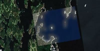
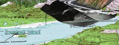
- I had never heard of the 500-meter high wave that swept through Lituya Bay, Alaska, after an earthquake in 1958. I do now, thanks to aerial imagery and a map that somebody has turned into a KML file. A lovely piece of geographic exposition.
- The variety of GIS, AEC and BIM 3D applications out there never ceases to amaze me. Version 5.1 of Navisworks Jetstream, which seems to be used for visualizing complex pipe assemblies, will now export to KML. (Mmm, it also has stereo viewing built in.) (Via JTBWorld)
- Following this Ogle Earth article on directional icons for weather symbols, Japan’s Bugs Bunny blog comes up with directional icons for photos, which depict the direction in which a photo was taken. I think that’s a wonderful idea. Here is Bugs Bunny’s example.
- One of the illustrations in this Cadalyst magazine article on how SketchUp is being used by new users and by schools shows a chess piece being made with SketchUp. Now that Battleships exists in Google Earth, this got me thinking… How about a chess game in Google Earth? Of course, it’d be a game where you move the chess piece not so much when it’s your turn but whenever you manage to travel to it. You’d then have to “carry” it to the correct square to drop it. Variations of the game could involve allowing you to “carry” up to two pieces at a time, say:-)
(Tron would also be a wonderful candidate for a real-life game, but it turns out it’s so wonderful that it’s already been done, as reported by we-make-money-not-art back in january 2005.)
- The US NOAA has a new website where many of its RIDGE radar images can be uploaded as KML. They’re asking for feedback, so: Except for the dataset with warning polygons,
only static downloads available. Is this for bandwidth reasons? Wouldn’t network links refreshing every 30 minutes or so make more sense for visual weather data? - Geosoft’s Dapple is a specialized application (Windows XP only) derived from NASA World Wind that focuses just on just the tools useful for the Earth sciences. Interestingly, the open source status of Dapple means that World Wind developers will be able to incorporate Dapple’s innovations in future versions of World Wind.
- 3D city updates: London’s Canary Wharf is also now available in Google’s 3D Warehouse, notes Digitally Distributed Environments. Vancouver has 3D buildings ready for your perusal, notes Google Earth Blog. (Note: Google Earth Mac beta has issues with Vancouver.) [Update 2006-07-23: La Défense in Paris is also available in the 3D Warehouse.]
- Speaking of Vancouver, GeoWeb 2006 is taking place there next week, July 24-28, and Google Earth CTO Michael Jones will be a keynote speaker.
Hi Stefan !
About Dapple, what a cool program you’ve find :o) The amount of data is very impressive and the program is very easy to use…
I take some screen capture :
http://www.cfm-guadalajara.net/dotclear//index.php?2006/07/22/1578-dapple-naviguez-dans-les-donnees-geospatiales-o
Re only static download for the radar images:
I selected “single image by radar”, “Chicago”, “composite reflectivity”. The icon in GE for “composite reflectivity” indicates an overlay, but in its properties it has a refresh of 2 minutes set. I’ve definitely seen it update. The image on the NWS site itself is actually updated every 4-6 minutes.
I assume all of the “single image by radar” images are similarly refreshed. The “all images for single radar” and the “single image statewide composite” also have a refresh of 2 minutes.
I thank for your nice article of Directional icons, and I thank for having introduced my blog.
I wanted a decided icon of a direction for a photograph.
I hope that Google Earth will support Directional icons in the near future.
Sorry that My blog is Japanies only. I’m not good at English.
(If you please corrected the link to my blog, I am happier:->)
Thanks for the corrections.
Bugs, your blog post is now linked properly.
Jim, you’re right, it didn’t occur to me that an overlay could also be set to refresh.
Thanks!
Jeff do nice 3d buildings for London, each time he put a new one in the 3d warehouse, I try to put one for the business area of Paris called La Défense. Good challenge.
Indeed, those are very nice. I’m updating the post with the link.
Stefan, it didn’t occur to me, either. I’m new to GE, and I was wondering if I could change those to network folders when I just happened to see the screen update.
No penguins, anyway (reg. southern islands)
What tools are available for Linux?
Google Earth Chess?
It already exists! checkout http://www.gechess.org I developed the game about 4 months ago. It works using php and kml. Its had over 600 registered players. A web interface written in php is used to move pieces on the Chess board. You first need to install the models (board & chess pieces) on your local drive before the game is viewable in Google Earth. You download the models after registering. The models were created using SketchUp.