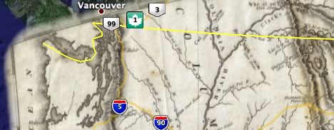
In the featured content folder this afternoon, four new layers, of which two are real standouts: A sampling of the famous David Rumsey historical map collection is now available as precisely positioned high-resolution superoverlays…
… and African metadata for Google Earth gets a boost with some very pretty layers by Tracks4Africa‘s community mapping effort:
I love it when Google pushes educational and progressive uses for Google Earth.
(Just one piece of GUI awkwardness: I went looking for the transparency slider for the Rumsey maps, and found it, but it’s in the Places sidebar, above the Layers sidebar, and it only becomes visible if you click on the containing folder. That’s not intuitive, especially as the Places sidebar might not be visible at all.) (Via Google Earth Blog)
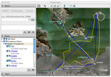
Yachting enthusiasts have long had recourse to sophisticated navigation software. I’m no expert, so when the makers of GPSNavX ($60-$100) let me know that they’ve added the ability to export a boat’s routes, waypoints and tracks to KML (so “friends and family can easily see your plans and progress with Google Earth on a Mac or PC”) I felt I needed to delve a bit deeper into this software niche before being able to have an informed opinion. Luckily there is a recent (Sept 2006) in-depth comparison by Practical-Sailor.com between all currently shipping navigation software, including the market leaders MaxSea and Nobeltec’s VNS.
Surprisingly, after more than a year since the launch of Google Earth, none of these other products mention exporting to KML on their respective websites (though some do export to GPX). Even more interesting is that GPSNavX gets a top rating in this article, is by far the cheapest, and is the only one of the bunch that runs on a Mac. In fact, you can buy a Mac Mini to go with the GPSNavX and still come out cheaper than the other software-only PC packages.
In addition, GPSNavX’s makers promise you will soon be able export GRIB weather files (the WMO standard) to KML. If all this sounds too good to be true, there is a free demo with sample chart, so try it out yourself if you’ve got a boat — admittedly, my desk didn’t travel very far while I played with the software.
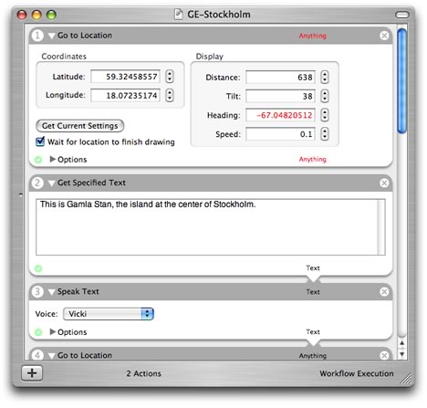
Many applications for the Mac are controllable via the AppleScript API — including Google Earth 4. AppleScript is simple, but it’s still code, which is why in OS X 10.4 you’ll find Automator, an application by Apple that lets you construct scripts simply by dragging and dropping predefined “actions” into a “workflow” — no coding required at all.
Now Nyhthawk at Automator.us has built two such Automator actions from Google Earth’s AppleScript library — it’s the Google Earth Action Pack (GEAP v0.3, so it’s beta).
The first action, Go To Location, works fine, and gives you the option of importing the current view in Google Earth, which is a big time saver. The second action, Save Screenshot, is hampered by the fact that the screenshots are saved in black and white, but that’s due to a problem currently with Google Earth’s AppleScript skills, not GEAP.
The obvious thing to do with these actions is to combine them with many of the default Automator actions to make presentations that include audio. Two such “workflows” are included on the download site, of Paris and Silicon Valley. I’ve made my own short one, of Stockholm (ZIP), and since many people don’t yet own a Mac, here is a screencast of how it plays:
(This only makes sense if you have the sound turned on.)
If you have a Mac, why is this better than simply playing a series of placemarks in Google Earth? Because you can add commentary, and because you don’t need to make placemarks if you simply want to show off some landscape. One limitation: Automator has no good easy way of playing prerecorded sound files, so at the moment you’re stuck with a robot voice. (Via MacNews.de)
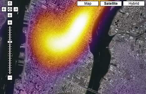
FortiusOne has just gone live with GeoIQ, a web service with API that returns heat maps for all kinds of geospatial data. The demo heat maps are overlaid on a Google Map, and aren’t just pretty to look at, they are also immediately useful. For example: Want to know where supermodels live in NYC? Here is a heat map for single women in their 20s making over $100,000:
The latest innovation is the javascript API, which lets you turn turn your own data into a heat map and add it to your existing implementations of Google Maps, Live Local and Yahoo! Maps. Get the making-of story on the company’s blog, which among other things promises the release of reams of open-source geospatial data next month.
This should also make for an interesting 3D challenge: In which virtual globe will it be easiest to return a GeoIQ heatmap overlay for a given view? The fact that GeoIQ’s API is accessed via javascript might point to a natural alliance with Microsoft Virtual Earth 3D’s API, but then again Google Earth’s network links can automatically query an external server in any language. Any takers?
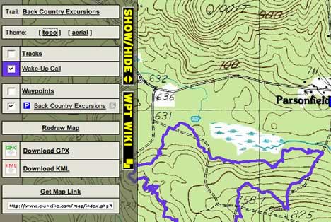
Some people make it all look so easy. Crankfire is a website for the Connecticut mountain biking community, run by Nathan. It contains a library of US biking trails with associated maps, photos and metadata. Now Nathan has added KML and GPX output to every trail map — just click on the show/hide bar to the left of the map. BTW, there is some really nifty DIY map coding here, incorporating layers, map permalinks and different dynamically loaded map types, all from within the browser interface. That’s big-league mapping on a small community site.
Finally, it’s catch-up time. Here is the first installment.
In the post about integration opportunities for Google Earth with other services, I mentioned a Google Calendar/Maps mashup, but said it never got past Beta. Andrew Turner from High Earth Orbit wrote in to say that his prototype, When2Where, made with MapQuest and Google Calendar, won a MapQuest competition a while back, but that he hasn’t had much time of late to polish it off and go “public” with it. In the the meantime, however, he’s working on adding a KML and RSS version of the MapQuest display, and is expecting to release it properly in January 2007.
Gerald L. Jackson at the Federal Office of Civil Aviation in Switzerland wants to know: is it possible “to specify a polygon’s upper and lower altitude? I create airspace segments in Switzerland, and visualize these in Google. […] The TMA segments have upper and lower mean sea level altitudes specified. The problem is Google can not lift these polygons off the ground showing a floating polygon. Can you point me to any guru on this matter? Many thanks!” Anyone here reading this NOT a guru?
I never blogged this, so it’s good that Adam’s blog has post on it, with accompanying screencast: If you place placemarks very close to each other, the latest version of Google Earth will have them fan out when you click on them, so you can choose the one you want. As Adam Burt notes, this is excellent news for projects where many different items are georeferenced to the same place, as happens with blog posts.
I’ve now had some time to explore Microsoft’s new 3D version of Live Local, Virtual Earth 3D (VE3D), a browser plugin for Internet Explorer 6/7 in XP/Vista. The skinny: it’s better in some regards than Google Earth, and worse in more important ways. That’s nevertheless a good showing for a first iteration of a virtual globe.
Advantage VE3D:
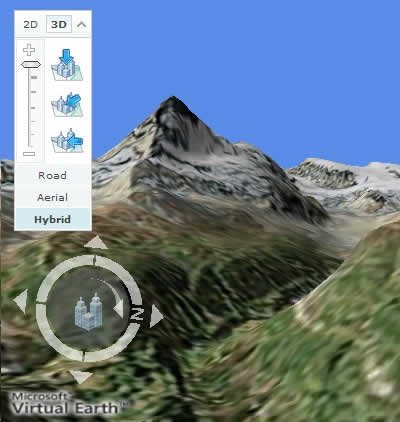
The Matterhorn test:It’s there by default in VE3D! (VE3D permalink.) Mountains in VE3D seem to benefit from a more detailed height mesh than Google Earth currently sports. (The Matterhorn is missing in Google Earth).
Permalinks for places and views: In VE3D you can permalink any view as a URL and then send it, save it, or bookmark it. Why is that better than making a placemark in Google Earth, adding a snapshot view, and sending or saving that? Because with Google Earth you still first have to download a KML file to your desktop, where it will sit superfluously until you trash it. Google Maps lets you create permalinks, Second Life lets you create permalinks, but Google Earth doesn’t. You can of course bookmark a spot in Tagzania, which will make a KML file for you on the fly, but you still can’t save views. The ability to save a place and a view to a simple URL is a winner due to its conceptual clarity — and it can only help bring users to the application.
Keyboard controls: VE3D has more keyboard controls. Look up above the horizon! Move up and down in addition to zooming in and out! Pan and rotate!
XBox controller: Given that last week somebody programmed a PSP to control NASA World Wind, this is no longer as cool as it should have been, but still, it’s a nice touch. And XBox controllers are cheaper than PSPs.
One unified Javascript API for both 2D and 3D maps: This is really neat; you can always rely on Microsoft to cater to developers, making it as easy as possible for them with a view to having them adopt a Microsoft technology; this in turn is meant to spur end-user adoption. An initial perusal of the code suggests that it is much easier to control the user’s view in VE3D than in Google Earth via the COM API or AppleScript. (But refreshing data without writing code is another matter. See below.)
The VE3D javascript makes possible a much more game-like approach to 3D environments than current virtual globes. What we have here in effect are the rudimentary tools for making a browser-based first-person 3D shoot-em up — or more likely, search-em up and shop-em up; I think James Fee is right on the money in this regard.
Advantage Google Earth
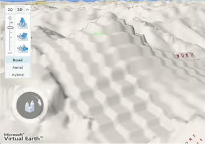
VE3D has larger height mesh errors: Although the Matterhorn is well-depicted, other areas that I know which I’ve checked up on for height mesh data — for example the Hunza valley (Ve3D URL) — sport extended errors:
(I used the Road view to show off the effect.) I can assure you that this mountain doesn’t look like that. Google Earth has had the benefit of multiple iterations of feedback for its height data — often by some very dedicated users.
VE3D’s place names are part of the base raster image?!Nul points, as they say in Europe — this is a real lapse that prevents VE3D from joining the major league just yet, but it is an inevitable consequence if you decide to forge your 3D map from your existing 2D product. In other words,
VE3D = 2D Live Local data + height mesh + 3D buildings
where the place names are rendered exactly as they are in the 2D map. In “traditional” online 2D maps, you can’t choose where north is (it’s always up, unless you hack it, as with Flash Earth) so this is not a problem, which in turn lets you gain speed by preprocessing the images, rasterizing text labels and icons. But with 3D maps you cannot assume north is up.
How does Google solve this problem? It keeps its images, placenames, streets (and other layers) distinct, flattening a subset of these into different pre-made sets of GIF tiles created specifically for Google Maps. Google Earth meanwhile serves the streets and names as separate vector-based layers, which means that names can always be served right side up. Even street names in Google Earth will switch direction at 180 degrees.
For Microsoft, the only solution down the line is to imitate Google Earth. There aren’t any shortcuts (that I can think of, obvs.). If currently there is time saved from sharing tile caches when switching from 2D to 3D in Live Local, then that advantage will have to go. Until this happens, there will be a lot of staring at upside down pixelated text after you zoom in and before VE3D catches up with you.
End-user creativity is harder in VE3D: Creating and sharing a collection of placemarks is easier in Live Local than in Google Maps or Earth. But for anything more complicated than drawing a shape, Google Earth offers far more sophisticated tools to help the end-user create new content without having to resort to code. Want to add an overlay? A GPS track? A 3D object? Automatically refreshing content? Only with Google Earth (and SketchUp) can you avoid writing code. (This is NASA World Wind’s big drawback as well.)
And once you’ve added that content, Google Earth induces you to share it (via Google Earth Community and 3D Warehouse). As before, this is where we see Google and Microsoft strategy diverge: Microsoft sees the end user more as a consumer that needs to be catered to, whereas Google sees the end user as an content contributor. This divergence now also shows up with how 3D buildings are dealt with: Google’s default buildings are basic gray shapes, with end users encouraged to build their own textured masterpieces and share them. VE3D’s 3D buildings, meanwhile, have been textured automatically and systematically. Which strategy will prevail? The jury is still out, but I think Google will eventually have to offer textured buildings by default. I myself have not caught the building-creation bug. But then again I’m not into property.
One advantage of VE3D’s approach is not to be underestimated, however: It produces a 3D world in which all users share the same world state, much like World of Warcraft or Second Life. Google Earth looks different for every user, depending on what they themselves have loaded up. Here again, VE3D points to being more game-ready.
Miles? VE3D’s scale legend is in miles only?! Nor is there any coordinate data to speak of, making VE3D hard to use as a geographic or scientific visualization tool. It’s much more of a main street browser than a geobrowser. The translucent green “cursor” is also much more World-of-Warcraft-like, and hence more inviting to being used in some kind of entertainment endeavor.
Perhaps we can simply conclude that VE3D’s target audience is not the same as Google Earth’s. VE3D looks geared towards gamers, shoppers, and virtual socializers. Google Earth has a far stronger scientific pedigree, offering prosumer GIS tools. Which target audience is larger? There’s the rub. This is where Microsoft’s gambit might well pay off — is now a good time to lament the fact that far more people got excited about ogling naked people in Google Earth than the ability to follow Shackleton’s expedition?
VE3D is for Windows XP/Vista and Internet Explorer 6/7 only. Companies that make websites that only work on a Win/IE combo are justly berated for willfully cutting themselves off from a whole tranche of potential customers. The whole idea of putting something into a web browser is that it just works for everyone, platform issues begone.
Why might things be different for Microsoft? Because it owns both a platform and a browser. If a compelling service is only available on Win/IE, then we might be tempted to run IE instead of FireFox, or Win instead of Mac — and Microsoft wins. Another reason for using an ActiveX plugin for IE is that IE is already installed on most machines, while a plugin is easier to install “under the radar” in most corporate environments. (Oh, and VE3D’s EULA doesn’t restrict its use at the office).
But what if you’re a developer thinking of using VE3D’s API? Then you’re making the same mistake as the developer making websites for Win/IE only. You’ll actually be building a PC application, though many potential users arriving at its doorstep will come with a web browser’s cross-platform expectations, and they will be turned away. That’s bad for business.
To concretize using Ogle Earth’s user stats: 18% of visitors here are not running XP or Vista (7% use Win2000). 30% are not using IE6 or IE7 — sure, XP/FireFox users could all switch to IE, but at the same time all Win2000/IE6 users (4% of total visitors) can’t use VE3D at all. These figures are nothing to worry about if you just want to hack, but for businesses or governmental agencies they should matter.
How does VE3D compare to SkylineGlobe? SkylineGlobe is also a plugin, but it is compatible with more flavors of Windows (Win95 onwards), with IE5.5 and now also with FireFox (kudos!). Versions for Linux and Mac are promised, says the FAQ (excellent). It also offers a free API, and the ability to render WFS, KML, WMS, Geotiff, SHP files, and live video, in addition to prebuilt 3D content. So perhaps VE3D most closely resembles SkylineGlobe, and developers should evaluate both.
VE3D is slow compared to Google Earth. Sure, it’s definitely “good enough”, but when switching back to Google Earth after zooming around in VE3D, the speed advantage of a stand-alone dedicated application is evident. On thing in particular I noticed: Google Earth’s compression algorithm appears smarter. You can see VE3D catching up by loading progressively sharper tiles if you zoom in quickly, rather than go straight to the high-resolution one you want.
Remainders:
Imagery and Internationalization: Microsoft’s catalog of high resolution imagery is not as extensive as Google Earth’s, especially for the bits that are not the US. But Microsoft does sport 45-degree bird’s-eye views, which are clearly popular. Google Earth also has better place search and (see comments) road data for more places, though Live Local shows it is stepping up to the plate by releasing a Japanese localization of its map tools.
Ads: Yes, Google has them too, but never in my screenshots, as is the case with VE3D.
In VE3D, when zoomed in close, switching to 2D sometimes leads to nothing at all — I would prefer zooming out automatically to the first available 2D level.
Pet peeve as a mostly Mac user: If Microsoft can detect that I have the wrong operating system and browser when I try to download the VE3D ActiveX control, then it should be able to detect this when I first visit Live Local, so I am not confronted with an invite to a service I can’t use.
VE3D does not at present support anti-aliasing, so flat horizons can show pixel effects.
Navigating VE3D goes all weird near the poles. You can’t rotate the globe across the poles, which is a strange limitation, as I can’t think of any inherent reason the technology should make this impossible.
In sum, Google Earth easily remains the virtual globe to beat, though that was also the case with Netscape when IE first showed up. In this battle, however, Microsoft isn’t copying the main competition wholesale, but is trying a different tack, trading in speed and cross-platform compatibility to allow for what appears to be a truly first-class 3D API. If it gets the developers to climb on board, then we should soon see some very interesting applications for users with PCs. Don’t expect these applications to be scientific or educational in nature, however, but more social, search and entertainment-oriented.