Panoramio, Wikipedia promoted to Google Earth’s default layers

newlayers.gif
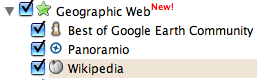
It was a good idea to turn on Google Earth this Saturday morning — even if the laptop was within destruction reach of a 1.3-year old niece who is attracted to keyboards like an ICBM to its target — because today there was the pleasant surprise of seeing two of the most interesting third-party network links turned into default layers, and placed in a new directory, “Geographic Web”:

  • Wikipedia’s georeferenced articles are now available via a layer of placemarks, with the popup containing an overview, photos, and links to further articles. The marriage of Wikipedia with Google Earth was a great idea, and now it’s available by default to a much wider range of people.
  • Panoramio, a site for sharing georeferenced photos that has long provided a network link of its photos, is also included inthe new directory. Panoramio’s photos tend to be more post-card/documentary than those on Flickr, so they have an easier time being useful in an educational setting.

In addition, the most highly rated posts of Google Earth Community now get special treatment. I tend to turn on all Google Earth Community layers if I’m zoomed in close and want to find out what I’m seeing. Amid the chaff, there is almost always an answer.

In sum, promoting the best content for Google Earth to a default layer (and presumably hosting it) is easily the biggest bang for the buck the Google Earth team can provide, as well as providing wider exposure for the content providers, and more stuff to do for users. Win-win-win. I’m looking forward to more.

Wee news: Live Local update; Shape2Earth; Swivel had an API

Short news, Edinburgh edition: GPSies, Swivel

And now I’m blogging from Edinburgh, also for work. Not as exotic as Taipei, but definitely better whisky. As a result, Ogle Earth continues in an inebr^H^H^H^H^H abbreviated edition…

  • GPSies - Tracks for Vagabonds

    GPSies (get it?): A really nicely designed community GPS site. Uploaded tracks can be exported in a wide range of formats, including KML and KMZ. It doesn’t do uploading of photos (yet?) but you can use the format converter without having to use the site’s social tools. Worth a visit.

  • Swivel is setting all data junkies to drooling. There have to be GIS applications for this — Valery Hronusov has already been alerted. Currently the site seems to be feeling the strain of being such an obviously good idea, but luckily James Fee found some time to play with it earlier.
  • Adam Burt releases the Geo-Blogging Tool Kit for the Mac’s ecto blogging client and the Blojsom CMS. It comes with a screencast so you can see how easy it is to use.
  • Got a lot of small screenshots of a region that you want to stitch together? Stitch Maps 2 might help. (Not tested.)
  • Press release: Water resources app maker MWH Soft releases NetView Pro, which visualizes analysis results on Google Earth:

    Initially introduced for InfoWater, the industry’s premier and most comprehensive ArcGIS-centric (ESRI, Redlands, CA) water distribution modeling and optimization software, NetView Pro is the first software to seamlessly combine mapping, GIS and modeling data with Google Earth in an integrated environment via an intuitive, easy-to-use interface.

    Not sure about the “first” bit, but isn’t this exactly the kind of stuff that is meant to be done with ArcGIS Explorer?

  • January 3, 2007 will see the release of an early version of World Wind Java, reports The Earth is Square. I hope this means it’ll work on the Mac.
  • Cambridge, UK, in 3D! (BBS post)
  • Google Earth’s been credited with many things, but the Daily News of Halifax asks, Can Google save Nova Scotia tourism?

    The province will also launch what it claims to be a worldwide first, using Google Earth to showcase Nova Scotia destinations.

    “It’s pretty cutting-edge,” said Lloyd Banfield, executive director of the tourism division for the Department of Tourism, Culture and Heritage.

  • 3DConnexion SpaceNavigator users, there is a forum especially for you.
  • A Francophone Google Earth community bulletin board (unofficial): googleearth.forumpro.fr.

ESA’s Miravi: Near real-time satellite imagery online

A month or so ago, the new ESA featured content layer in Google Earth left me a little underwhelmed: Placemarks with links to relatively old and low-res imagery on the web are so — how shall we put it — 2005. But today comes news of something much more impressive, with much more potential: MIRAVI (MERIS Images RApid VIsualization), a new website with near real-time images taken with ESA’s Envisat satellite, posted directly to the web for immediate download. There are at dozens of new images added every day, and they come with a full complement of scrapable metadata, including the coordinates of the edges… which means that all the necessary information is there to produce a KML network link with proper overlays of the latest data automatically. ESA should of course offer this (and perhaps they’re working on it), as it is clear synergetic addition to the site. But until ESA does it, is anyone game to have a go? That would definitely deserve “featured content” status in my book.

PS: Notice how cloudy it is in most places most of the time? It makes you realize how rare the imagery that ends up being used in Google Earth is.

Short news: Trulia, Gaia, OpenStreetMap, Windguru, ArcGIS Explorer

  • S. Fjalar in Iceland proposes a class project for school: Use Google Earth imagery to make inspirational-style posters. See some of the results at the Artwork Earth Flickr group.
  • West Virginia University’s GeoVirtual Laboratory plays with Virtual Reality Geographic Information Systems. Looks like the amalgamation of a couple things I’ve seen elsewhere on the web. (Via W. David Stephenson’s blog)
  • Trulia real estate searches can now be saved as a live network link. Not entirely new, but very nicely implemented.
  • Gaia gets rid of the Google Earth imagery, but continues developing, and gets its own project page on SourceForge. In case it wasn’t clear before, it’s for Linux.) The Earth is Square reports Gaia will get support for NASA World Wind imagery in its next release. Good to see.
  • Talking of data: Over on OpenGeoData, Steve Coast announces that Yahoo! has agreed to let OpenStreetMap, the open source mapping project, use Yahoo! Maps’s satellite imagery. Rev Dan Catt cheers them on.
  • Windguru gives wind conditions for windsurfers in many different spots. It now comes with a KML link. (Via 5 minutos)
  • In the absence of Ogle Earth’s own review of ESRI ArcGIS Explorer (it’s coming, it’s just so damned busy right now), here are some others currently on the internets:
    • Andrew Smith at Digitally Distributed Environments: “At first look ArcGIS Explorer is sadly disappointing with poor rendering of KML files and the ability to add data only if you are GIS literate.”
    • Over on Dot Net Without a Net, Matt Priour reviews ArcGIS Explorer. Verdict: “This is going to be a niche product. If they can get the speed up to some reasonable level, I think it will be a really good one.”
    • SpatialLink has initial impressions.
  • Dave Bouwman does some Google vs. ESRI as opposed to Google Earth vs ESRI ArcGIS Explorer. Interestingly, Dave’s guestimates are remarkably close to mine, from last year.
  • Geotagger, Craig Stanton’s Mac application that georeferences photos using Google Earth, is up to version 1.1.
  • Google Earth is one of 5 nominated for “product of the year” by a Belgian marketing congress, in collaboration with the Standaard, one of Belgium’s largest newspapers. Also on the list: YouTube, the GPS device, podcasts, and digital TV. The GPS device already won last year. I guess you can win twice. (Via Belgeoblog)
  • On Slashdot: A contributor discovers a Microsoft van collecting street-level imagery. Ready to be pasted at the street-level into Virtual Earth?

Run ArcGIS Explorer on your Mac

Here’s a fun GIS party trick: Run ArcGIS Explorer as an application inside Mac OS X. While you’re at it, run SkylineGlobe as well: (Click on the image to enlarge)

parallels-small.jpg

No, they didn’t just come out with Mac versions. Instead, Parallels came out with an update to its excellent Windows virtualization software for Mac. Two new features were added: The ability to run individual Windows applications just like any Mac application right in the OS X GUI, and the ability to use the Boot Camp partition with Parallels.

The first feature makes it look great, but what does the second feature mean? Apple already lets you boot into a separate partition on your Mac where you can run Window XP or Vista natively on the Intel Core Duo processor. Parallels, meanwhile, lets you create and run virtual disks with all kinds of Windows or Linux installs, and with virtually no speed penalty. With this latest update, Parallels now also lets you run your Boot Camp install from within Mac OS X, simultaneously. Before, you had to reboot if you wanted to use Boot Camp.

There is just one thing missing, still, in Parallels: 3D hardware acceleration. You do get full OpenGL and DirectX support in Boot Camp, so you can still reboot into it if you really want to access 3D functionality on your Mac, but that takes minutes. Parallels promises to add 3D hardware acceleration support in the coming months, but until then, here’s a rundown of compatibility for the current set of virtual globes.

Mac OS X:

Google Earth: Yes

NASA World Wind: No, but Java version promised

Microsoft Virtual Earth 3D: No

SkylineGlobe: No, but Mac version is promised

ESRI ArcGIS Explorer: No

Windows via Parallels in Mac OS X:

Google Earth: Yes (no 3D acceleration)

NASA World Wind: No, only runs with 3D hardware support

Microsoft Virtual Earth 3D: No, only runs with 3D hardware support

SkylineGlobe: Yes (no 3D acceleration)

ESRI ArcGIS Explorer: Yes (no 3D acceleration)

Windows in BootCamp:

Google Earth: Yes

NASA World Wind: Yes

Microsoft Virtual Earth 3D: Yes

SkylineGlobe: Yes

ESRI ArcGIS Explorer: Yes

So although NASA World Wind and Microsoft Virtual Earth 3D are currently not accessible via Parallels’ solution, this will change in a matter of months, either because the Java version of NASA World Wind has come out, or because Parallels adds 3D hardware support to their product.

None of this should mean that developers can stop developing for the Mac, of course. To use Parallels or Boot Camp with Windows, you need to own a copy of XP or Vista, and that’s not cheap.

Peeking at Hezbollah’s intelligence

Rip sends an interesting submission, and wonders if this is an example of Google Earth imagery being used as intelligence in warfare.

Northeast Intelligence Network has posted images of a Hezbollah command and control bunker captured by Israeli forces during the Lebanon war from last July. One of the images shows a wall montage of satellite imagery that is immediately recognizable as being of northern Israel:

hezidf.jpg

Rip wondered if that might be high resolution printouts from Google Earth. Well, there is a way to check:

geidf.jpg

Notice there are a few clouds near the green fields in the center of the Google Earth image, so we can be sure Hezbollah’s intelligence does not come via Google Earth. Why should it — Iran has access to much better than 2-meters-per-pixel resolution, which is what is currently the highest resolution publicly available.

This also means, of course, that the argument against releasing high resolution imagery of Israel is weak. Those who want to do Israel harm already have access to the imagery, so why not release it to everyone, where it might do some good?

Notes on the political, social and scientific impact of networked digital maps and geospatial imagery, with a special focus on Google Earth.