Links: Interview with DigitalGlobe CEO, some good new blogs

So I can start my week with a clean slate, here’s what’s been in my queue:

  • The Denver Post interviews Jill Smith, CEO of DigitalGlobe. No hard-hitting questions about censorship, though:-)
  • Early 2007 has seen a mini surge in promising geoblogs. Here are some that have grabbed my attention of late:
    • MapWrapper.com — “Geography EarthScience and Mapping with a little news and my Favorite stuff”.
    • Google Earth Hacks blog — “Everything you need to know about Google Earth”. Mickey Mellen’s Google Earth Hacks was first out the starting gate as an independent repository for placemark collections, overlays and screenshots, and even today the site remains one of the largest and most active of its genre. The site’s news page languished for a while, but now it’s been relaunched as a group blog, and it looks promising. (Ogle Earth interviewed Mickey back in August 2005 — how innocent we all were then:-) Mickey’s also responsible for the first Google Earth game, GEWar.)
    • Mapperz — “The Map and GIS News Source Blog”, has been stepping up the pace recently, with a high ratio of original finds, mainly of interest to Maps coders and GIS developers.
  • Back in November, The City of San Jose Planning Division posted a video of the city in 3D. But now the days of watching San Jose passively are over — they’ve just posed the KMZ file with the buildings for all of the downtown.
  • Sandio’s new 3D game mouse, touted as being compatible with Google Earth, gets reviewed, sort of. (Via Oh Gizmo!)

WSJ: Google may buy in-game advertising firm

In the Saturday edition of the Wall Street Journal, this article: Google’s Next Ad Frontier May Be Inside Videogames.

The Mountain View, Calif., company is in talks to acquire Adscape Media Inc., a closely held San Francisco company whose technology allows for the delivery of advertising over the Internet and placement within videogames, according to people familiar with the matter. They added that a deal could be reached as early as next week.

While the possible terms of a deal aren’t known, Microsoft Corp. last year acquired Massive Inc., a company that delivers in-game ads, for close to $200 million. […]

People familiar with the matter say Google had looked at Massive prior to Microsoft’s acquisition of the company. A purchase of Adscape would add a new front to expanding competition between Google and Microsoft, which today stretches from Web search to word processing. Google could look to form an alliance with Microsoft’s archrival in the games console business, Sony.

The article doesn’t mention the most prominent place where Massive’s technology has been put to use since its acquisition — Virtual Earth 3D, in the form of in-world billboards. Now that the latest release of Google Earth 4 has much improved 3D city content as a default layer, I think it is entirely reasonable to begin speculating whether Google Earth will eventually see similar forms of in-world advertisement. (Via MIT Advertising Lab)

Basra: New Daily Telegraph article has no clue

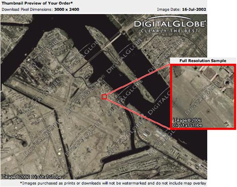
A week after it was first reported here, The Daily Telegraph had the news today that Google has replaced its satellite imagery of Basra from September 2004 with imagery from July 2002. Of course, it didn’t report it like that. Much of the article is either presumptive, tendentious, inaccurate or unsourced.

Google blots out Iraq bases on internet
By Thomas Harding, Defence Correspondent
Last Updated: 2:07am GMT 20/01/2007

British military bases in Iraq have been “blotted” out from Google Earth maps at the request of the Government to hinder terrorist attacks, it can be revealed.

  • I’d have preferred it if Google had actually “blotted out” the bases. That’s how the Dutch censor their sensitive sites — it maintains one’s confidence in the rest of the dataset. Instead, Google replaced newer imagery of Basra with older imagery; it has yet to admit officially that it did this, by the way, or explain the rationale for doing so now and not in other situations.
  • The Telegraph’s “it can be revealed” is ridiculous. Had the paper started up Google Earth and looked at Basra a week ago, it could have reported that the bases were missing then. It didn’t. The internet did all the work, but admitting as much is something the paper is clearly incapable of. (If it does have independent confirmation of an agreement between the UK and Google, it is unsourced — there is not even a “sources say”, it is merely stated as fact.)
  • Caring about the moral gradiations between terror attacks on civilians and guerilla attacks on military bases is supposed to be what differentiates “us” from “them”. The Daily Telegraph conflated the two notions in last week’s article, “Terrorists ‘use Google maps to hit UK troops’” and continues to do so in this article.

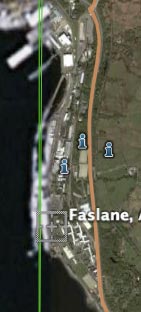
Sensitive installations such as the Trident nuclear submarine pens in Faslane, Scotland, and the eavesdropping base at GCHQ Cheltenham have also been obscured, a search of the site shows. […]

Research by The Daily Telegraph has provided some interesting images. In addition to Faslane and GCHQ the entire aerial footage of Hereford, home to the SAS, has been fuzzed out. But the Special Forces Support Group headquarters, which provide additional troops for the SAS, in St Athan, Wales, is shown vividly with airstrip and barracks. Similarly, pictures of the Royal Navy base in Portsmouth show with some clarity aircraft carriers, frigates and destroyers in the harbour.

Other clearly visible sites that could be useful to terrorists include MI6 headquarters in London.

faslane.jpg

  • Absence of evidence is not evidence of absence. I can’t believe that Harding simply zoomed in on a couple of military installations in the UK and listed the ones that weren’t in high resolution as having been “obscured”. (There is not even a modifying “apparently”.) Cheltenham GCHQ and all of Cheltenham, like other large swathes of the UK, are still in low resolution. No Google Earth Community placemarks in the area hint at having been made on top of high resolution imagery that is no longer available. (In nearby Gloucester, which does have high resolution imagery, you do find such placemarks.) You can do the same exercise for Hereford.
  • Saying that the Trident submarine base northwest of Glasgow has been “obscured” is just plain embarrassing: Most of it is in fact visible, as it lies just on the edge of a high resolution tile. Also, the imagery has looked like that since at least August 2005, as this comment on GEC reveals.

Google was first alerted to the security breaches after personnel at the British headquarters at Basra Air Station in Iraq were astonished at the clarity with which all their positions were shown on the popular internet site. […]

Following negotiations, Google agreed to blot out British bases in Iraq after the company was persuaded they would be helpful to terrorists.

But it was not done early enough to stop insurgents obtaining copies of the pictures which, with the longitude and latitude given, help them co-ordinate mortar and rocket attacks.

As revealed in The Daily Telegraph last week, an insurgent arrested by British troops in Basra was found with a Google Earth map of the Shatt Al Arab base, home for 1,000 soldiers.

  • The above paragraphs are the only potentially new piece of information in the article, if it is in fact based on sourced information and not inferred from a vague statement by Google that it had “opened channels of communication with the military in Iraq.”
  • If true, then Google had agreed to replace the more recent imagery of Basra with older imagery before the insurgent with the print-out was arrested last week. That would imply that the imagery switch had been made earlier than the previous week. Considering how everything else in this article is so shoddily reported, however, I just don’t know how much credence I can lend this information.

Not that any of the above will make much difference. The internet and old media are both already busily repeating without verifying that Google “blotted out” bases in the UK as well.

Links: British Library Maps in KML, GeoCommons, Google Earth Panorama Viewer

Once again, too little time, too many cool things happening. Much abbreviated, then:

  • Ooh. London, a Life in Maps, an exhibit at the British Library, gets its own KML layer with antique maps for Google Earth. Gorgeous. (Via GEC, thanks to Valery for the heads up.)
  • FortiusOne’s GeoCommons continues to look promising. In yet another sneak peek of what it will be able to do, The company blog Moving Past Push Pins shows how the Dutch noise-level sensor web data blogged on Ogle Earth just yesterday can easily be converted from its “text” KML format into a graphical heatmap overlay. A must-read for KML developers.
  • You read it here last, but that doesn’t make DigitalUrban’s Escheresque Google Earth Panorama Viewer any less spectacular. It’s a 3D sphere onto which you can stick 360-degree panoramas and then navigate through; it’s a must-see if you haven’t already. Juicy Geography makes something with it, and so does Nearby.org.uk. Frank Taylor adds some tips for those without SpaceNavigators.
  • Sprol, a blog that chronicles the “Worst Places In The World”, pollution-wise, gets its own KML file with links to all its stories, which were previously only illustrated with views in Google Earth. Now you can check out the pollution directly.
  • The deadline for proposals for the 5th International Symposium on Digital Earth, taking place 5-9 June 2007 in San Francisco, has been extended to Feb 28. I’ll be there in June.
  • James Fee’s been beta-testing Arc2Earth Publisher and loves it for its easy ability to publish ArcMap work in a number of formats, including KML.
  • Rev Dan Catt shows us what’s in the future of tags: Basically, tags will be geocoded, if at all feasible. Tag something “Eiffel Tower”, and to Paris it goes on the map. Very cool.
  • The Alaska Volcano Observatory gets a writeup in Wired. John Bailey showed off a KML visualization of its new analysis system at the American Geophysical Union annual meet last month, writes Wired, and they’re planning on releasing a Google Maps-based visualization soon. Hope that comes with KML.
  • The SRTM KML Project. A shaded relief overlay for Google Earth.
  • If you’re going to monitor cruise ships in Google Earth in real time, why not represent them as accurately as possible with a model? That’s what “Svens” thought. Works like a charm. Cruise ship companies should do this as a PR move and get press for it.
  • Liccavi Open Earth IDE is a tool which you can use as a gateway to all other popular map applications like Google Earth and Microsoft Virtual Earth. With Open Earth, you can browse all other map servers and use their content as the base data to build the Liccavi Earth content.” I’ll keep better tabs on this when I have time.
  • OpenStreetMap (OSM), the open, editable, free mapping project, now gets an XSLT style sheet that converts its .osm file format to KML. (Via OpenGeoData).
  • A quick video of what SketchUp PhotoMatch can do.
  • Microsoft Publishes RFP for Virtual Earth Academic Research Collaboration.

KML documentation gets a refresh

Straight from Mountain View, courtesy of Googler John Gardiner’s Using Google Earth blog, news that the KML reference materials have been updated. Check out:

  • A KML 2.1 tutorial, including explanations of regions, textured 3D models, incremental updates and more.
  • A KML 2.1 Reference, containing a thorough run-through of tags and attributes.
  • KML Samples which are self explanatory. This is also where you find the proper KML MIME types you need to add to your server’s config files to get them to serve KML properly.
  • And finally, a proper link to the KML 2.1 XSD schema.

DigitalGlobe removes Basra imagery from online store

What a difference a day makes. If you check out the Digital Globe Online Store now, as we did on Tuesday, you no longer get imagery of Basra from 2004 for sale, but the same pre-war imagery from 2002 that Google currently shows:

afterfgd.jpg

Also worth noting is that Mike Williams’s excellent Google Tile Comparisons tool is now off-line — though perhaps that may be due to The Register taking an interest in the story today.

The removal of the September 2004 image from the Digital Globe Online Store during the past 48 hours provides rock-solid confirmation, in my mind, that there has been a concerted effort to close this particular barn door. And without implying any normative judgment, this amounts to the first documented case of self-censorship by Google in Google Earth.

All of Hamburg goes 3D

0,1020,778957,00.jpg

Many German news sites are abuzz just now with the announcement a few hours ago that the entire center of Hamburg has been made into a massive 3D model for Google Earth. Spiegel Online has the best coverage, with photos and a video preview too. Some excerpts, translated:

“This is a world premiere,” said Google spokesperson Stefan Keuchel at the presentation of the project today. “With the textures on the facades [of buildings] Hamburg is the first city worldwide to be visible in this detail. Hamburg 3D will be live in a few days or weeks.

So we’ll have to wait just a little bit more. (More images at Die Welt.)

Looks like Denver was just practice. It will be interesting to see how fast such massive 3D models render on the average computer.

Also important to note, again, that this content is neither user generated (most models) nor Google’s own doing (like Denver), strictly speaking, but a hybrid. Writes Spiegel:

The project was not initiated bu Google, but by the Hamburg@Work initiative, which is sponsored by both the city and private businesses. Google spokesperson Keuchel said that Hamburg approached Google and proposed the project.

The stated reason: To promote tourism. Hamburg was digitized and turned into a 3D model by Cybercity AG, yet another innovative Swiss company.

Notes on the political, social and scientific impact of networked digital maps and geospatial imagery, with a special focus on Google Earth.