Terrorist propaganda video shows off Google Earth imagery

Il Corriere dela Sera, a serious italian newspaper, has an article out today about a potential terrorism campaign that might be conducted by Tunisian Al Qaeda-ists in the run-up to the French presidential elections.

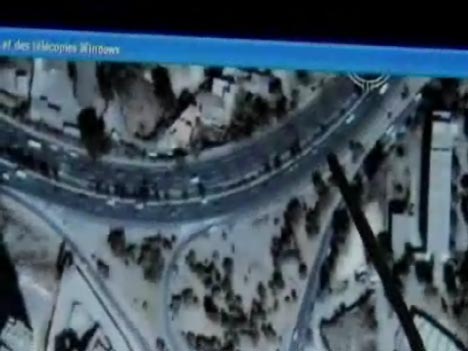
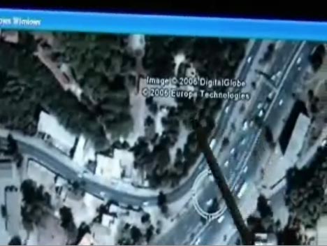
It quickly gets interesting for Ogle Earth readers when the article links to an Al Qaeda propaganda video, apparently documenting this attack on a bus carrying expats in Algeria on December 10. About one third of the way through, you see a screen that clearly shows images taken from Google Earth, with somebody scoping the scene of the attack. Interestingly, what the propaganda video shows is stitched screenshots, rather than Google Earth running:

terrscreen.jpg

terrscreen2.jpg

[Warning: the video ends with footage of the actual bombing — as if you needed reminding of the sick glorification of violence these people engage in.]

You can of course never take anything you see in this kind of video for granted; the intention may be, in part, to ensure we lose unfettered access to information as yet another consequence of their attacks.

Il Corriere‘s article mentions other instances of aerial mapping being used by terrorists and militants, some of which I haven’t seen documented before: Images “taken from the internet” of western embassies in Tunis, recovered from Tunisian militants; the Basra affair, which prompted Google to roll back its image update to before the Iraq war, images recovered from an Al Qaeda hideout in Fallujah, apparently showing targets in Europe, and aerial imagery found in an abandoned Hezbollah outpost during last summer’s Israel-Lebanon war. Hezbollah’s imagery was shown not to be taken from Google Earth. Il Corriere missed this one: A foiled attack in Yemen. Note: Except for the Hezbollah story, all original sourcing for these stories is unavailable — there are no means to verify independently the claims of any of the actors in these conflicts — and in war, truth is expendable.

Links: Australia gets directions, Fledermaus gets KML

  • Google Earth now has addresses and directions for Australia, though no roads (as of yet). Doing a search for the place where I used to live Sydney proved spot-on:

    belevuehill.jpg

    (Thanks to Michael Smalley)

  • Kurt introduces me to yet another 3D visualization system — IVS3D’s Fledermaus. It seems to be particularly suited to viewing and manipulating bathymetry data, and even comes in Linux and Mac versions.

    Kurt also shows off a new feature in the latest version, 6.4 — exporting to KML. His screenshots and explanation are worth a look. (No info on pricing for Fledermaus, so I’m pretty sure I can’t afford it.)

  • eZ publish, which I had not heard of before, is a Norwegian open source content-management system. Bjørn Sandvik used it to create KML templates, and you can see the resulting KML-savvy web pages here (in Norwegian).
  • Google Earth Blog highlights an innovative way to bring in-world video to Google Earth via clever use of the timeline.
  • NASA World Wind 1.4 is due on Valentine’s day. Aw.

CyberCity: More 3D cities coming to Google Earth

This article was online, disappeared, but has now shown up again: Switzerland’s NZZ Online profiles CyberCity, the Zurich-based company behind the (impending) 3D version of Hamburg in Google Earth. Choice excerpts:

[Google] has already snapped up a three:dimensional model of Hamburg from the Swiss creators and has now asked them to supply more cityscapes with levels of detail currently unavailable on Google Earth. […]

“We are confident that we can have a productive relationship with Google in the coming years,” said [CyberCity managing director Franz] Steidler. “This is quite a breakthrough for us.”

The company already has a stockpile of some 50 cities mapped out in 3D detail in its database, including Paris, Salzburg, Florence, Los Angeles, Chicago and parts of Zurich.

“We will get a list from Google of what they want from us,” added Steidler.

What’s interesting is that the original initiative for putting CyberCity’s 3D Hamburg into Google Earth came from Hamburg’s local government and businesses, not Google; though now it seems that CyberCity’s other offerings have caught Google’s eye.

Clearly, the competition that is driving both Microsoft and Google to ever-greater lengths to impress users is unequivocally a Good Thing ™ for us:-)

Yahoo!’s Pipes — The universal mash-up engine

logo_1.gifToday I’ve been eagerly waiting to get into Pipes, Yahoo!’s most excellent-sounding universal mashup engine — and so has everyone else, as it’s been down ever since I heard about it on TechCrunch. (Maybe it’s because Tim O’Reilly called it “a milestone in the history of the internet.”:-)

As I haven’t actually had a chance to play with Pipes, I’m not going to describe what it is, instead leaving that to these two great examples (one and two) by Kevin Cheng.

I don’t think Tim O’Reilly is dabbling in hyperbole. For neogeographers in particular this will be something of a big bang, I suspect.

How? For starters, Kevin Cheng’s examples output GeoRSS by default, and the entire “pipe” is geospatially enabled.

Second, KML support is coming! From Yahoo! ! Check this out:

While Pipes today lets users mix data from RSS and Atom feeds, Yahoo hopes to extend the service to support other data formats, Web services, processing modules and output renderings, Yahoo said. For example, Yahoo will open up access to the Pipes engine to programmers and add support for the KML data source, which is used to display geographic data in Google’s popular Google Earth mapping application and Google Maps website.

Start combining this with the power of the network link and we’re suddenly at a whole new level of mashing — where decision engines, inputs and formatting are all turned into interchangeable web services. This is much more than what XSLT stylesheets can do to XML.

I can’t wait to see what GIS pros and amateurs come up with:-)

Links: OrbVista, Jim Gray, Google Earth cacher

  • OrbVista takes NASA’s public domain imagery and presents it in a semantically richer environment, with a view of the area in Google Maps and with a link to Google Earth. “All” that is left to do now is to automatically generate a KML overlay for the imagery:-) Great stuff. (Via Dan Karran’s Del.icio.us links)
  • I was AFB (absent from blog) as the Jim Gray disappearance story turned into a huge distributed effort to find him. While things are looking grim for Jim Gray, I hope the distributed search & rescue effort sets a precedent, and that this innovation gets to save many lives in the future.
  • DestinSharks’s Virgil Zetterlind reviews the Google Earth Voyager, a PC application that caches the high resolution imagery of a specific region so that you can later use Google Earth to navigate through it without an internet connection, using a GPS device. Virgil’s verdict: It works as advertised. (Use caution when installing unverified software.)
  • New Virtual Earth blog: Virtual Earth for Government.
  • A NASA World Wind Java FAQ, courtesy of The Earth Is Square: Short version: The public beta is due in April.
  • Google is taking part in the Cairo Information and Communication Technology (ICT) Exhibition currently underway, showing off Google Earth.
  • Still waiting on Hamburg’s 3D buildings…
  • Virtually every online news site has now reported that Google has agreed to “blur” sites in India, and they are all wrong. What do you think the chances of getting a correction are? I’m not holding my breath.
  • In case you were wondering how difficult it is to overlay a map on top of a Virtual Earth, the answer is: Not difficult at all. Here is a five-minute video tutorial of Mapcruncher to prove it, using a map of destroyed villages in Darfur. The result is more accurate than putting an overlay in Google Earth, though it isn’t visible on my Mac. (Via Virtual Earth blog)
  • Virtual Earth’s Steve Lombardi is soliciting feedback for the Virtual Earth API. I think it would be lovely if it could work on my FireFox for the Mac. (Via Via Virtual Earth)
  • Another default layer for Google Earth: Sunrises, courtesy of the Discovery Channel. It’s very pretty, but technically this is nothing new. What I’d like to see is not a KML file containing placemarks that link to videos, but the pop-up windows themselves being able to play videos. Or how about the ability to overlay a video on Google Earth?

ObsKML anyone?

Remember ObsRSS, the brainchild of sensor-web weaver Jeremy Cothran that adds some metadata tags to the RSS XML schema? Now he’s come up with ObsKML, which does the same for KML.

For a detailed discussion and examples, this is the thread you need over on Google Earth Community.

Jeremy’s motivation?

It would be great if Google or some group or organization could throw some more attention on this issue in regards to KML. KML standardizes the ‘where’ and ‘when’ information within a popular and easy xml standard and it would be interesting to see the ‘what’ part of this data stream standardized also. Separating data content from data display into a more standardized xml schema would allow KML to enable better end user data reuse, aggregation and styling needs.

As far as I understand it, KML is a tradeoff between ease and power. For a fully descriptive mark-up language that properly separates style from content, try GML, though it is harder to use.

Notes on the political, social and scientific impact of networked digital maps and geospatial imagery, with a special focus on Google Earth.