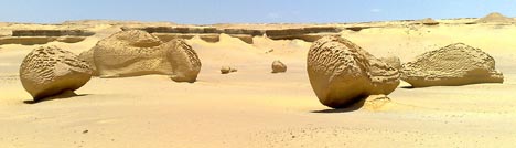
Yesterday’s trip to Wadi El-Hitan, Whale Valley, exceeded all expectations. I’ve never seen anything remotely like it, and I’ll be writing more about the experience on my personal blog.
I used the day as an opportunity to field-test the Nokia N95 as well as some GPS-enabled mobile applications — Mobile GMaps, GMap-Track and Shozu. My co-traveller friends thought I was a being an utter gadget freak, but I think I was able to convince them I was only doing this because I had promised I would write it up on Ogle Earth.
So how did the Nokia N95’s GPS functionality fare in real-world conditions? In short, really well. For the sake of concision, some subheaders:
Nokia N95 – GPS reception: The problems I was having getting a satellite fix on the N95 disappeared as soon as I hit the flat expanses of the desert. Cairo’s buildings are almost all made of reinforced concrete, which bounces GPS signals — in the more rural areas, I could get a fix in well under a minute, instead of the 5+ minutes in an open area in the middle of Cairo. For the duration of the trip, I had the phone simply lying next to me in the car — there was no need to hold it near a window to get a GPS fix.
Nokia N95 – GPS Accuracy: The Nokia N95’s self-reported accuracy was never better than around 100 meters or so. That would be terrible, if true. Fortunately, I also had with me a Garmin etrex Legend, and it was getting accuracy readings as good as 4 meters (which is fantastic), so I could compare the positions the N95 gave to the photos I took with it with the Garmin’s baseline reference. It turns out that the N95 was attaching coordinates to photos that were always within 10 meters of the track that the Garmin was laying down:
Nokia N95 – Image quality: I ended up taking about 50 photos while at Wadi El-Hitan, all at the maximum 5 megapixel resolution, and put most of them up on Flickr in this set, so you can check out the quality of the original format yourself. I think the quality is very good — these images are all unmodified from the original.
Nokia N95 – Battery life: This is the N95’s much discussed Achilles heel. On the way to Wadi El-Hitan, I had Mobile GMaps running for as long as we had cellphone coverage (the first two hours out of three), with the GPS functionality turned on, and with a data connection sucking in new Google Maps imagery as required. This consumed 2 out of the 7 bars on the battery indicator.
Then I spent two hours taking around 50 5-megapixel photos with the GPS functionality turned on. Just as we were returning to the car, the low-battery warning appeared, so I turned the phone off. I think the 5-hour runtime I got was quite respectable, considering what I was asking the phone to do. A second battery is a must, however, which is perhaps why they are impossible to find at the moment.
Mobile GMaps: I think I’m in love with this application. I really did get to sit in a car travelling through rural Egypt as my mobile phone showed me scrolling high resolution Google satellite imagery, with a marker showing where I was at that instant. If we were driving past fish farms on the right, there were fish farms on the satellite image. A palm tree grove on the left? There it was on the image, right down to the individual trees. It’s the stuff of Sci-Fi or James Bond, except now it’s on my phone. It helps that Egypt, like most developing countries, has an extensive modern mobile phone network that allows data downloads, often at 3G speeds. As for how much this roaming cost me exactly, I have no clue yet:-).
Mobile GMaps controls the GPS functionality directly, so you don’t need to run Nokia’s default GPS application on the side. It doesn’t cache your data, however, so you really do need to be within cellphone range to use it. Placemarks in KML files that you may have downloaded previously are not cached either, so if you can’t download the file again, for example because you’ve driven into the middle of the desert, then its contents are not available to you and the application merely crashes. It would be very useful if you could save/cache both imagery and KML placemarks, so that you can browse content when outside cellphone coverage — which is where most interesting nature destinations tend to be.
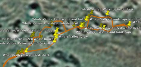
GMap-Track: This service also worked exactly as advertised:
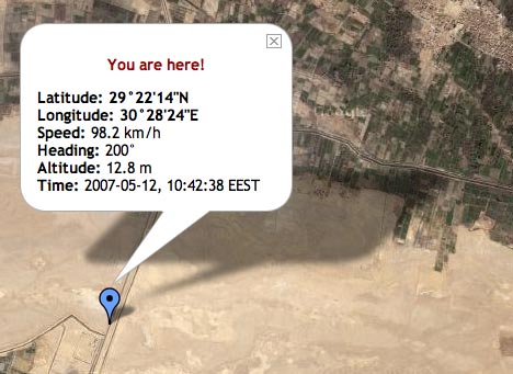
This is the last location the N95 reported, because soon after that we left cellphone coverage. But we were indeed going at nearly 100km/h in a south-southwesterly direction at that very moment. All I want now is access to a permalinked URL that shows my last position, instead of a public map that shows everyone’s. Another nice feature would be a subscribe-able network link that updates my position periodically in Google Earth.
Shozu: I’ve already written up Shozu enthusiastically. One thing it doesn’t do (and this wasn’t clear to me before) is write coordinate data to the relevant EXIF fields. I discovered this when I uploaded the images to Aperture this morning — the EXIF fields for latitude and longitude were left untouched. What Shozu does when I take a photo with the N95 is use the GPS fix to write geotags that are understood by Flickr. I’m hoping Nokia will soon update its camera software so that GPS data gets written to EXIF natively. The N95 has all the hardware to make it happen, so it’s a pity Nokia’s software isn’t making use of it.
Shozu also, of course, can’t upload my photos to Flickr when I am out of range of cellphone or wifi coverage. I ended up waiting until I got home before uploading full-size versions of the images to Flickr via my own wifi connection — in part also because I had run down the battery.
So, to conclude, The N95 performed admirably — I had no out-of-memory errors on the day, and the only crash happened when Mobile GMaps was left without cellphone coverage.
Here’s a KML file containing all the relevant contents for the day: The track made by the Garmin Etrex Legend, the boundaries of the Wadi El-Hitan protected area, and all the georeferenced photos I took with the N95, uploaded to Flickr via Shozu.