- Social spying, cont.: Everything you’ve ever wanted to know about Iran and North Korea’s deployment of S-200 surface-to-air missile systems, courtesy of Sean O’Connor in his IMINT & Analysis blog, using copious screenshots from Google Earth.
- ImageAmerica: Want to know what ImageAmerica did before it was bought up by Google? Here is what their site held in February 2007, courtesy of the Wayback Machine.
- Java geoconverter: Via the comments, “yet another route converter“, this one using the Java Runtime Environment, so it is very multi-platform.
- Cosmic: Barnabu just keeps on outdoing him (her?) self. The latest: Cosmic microwave background radiation on a sphere!
- GPS with iPhone: Does the iPhone do GPS tracking? In a manner of speaking, yes, albeit convolutedly, using an external GPS tracker and Mologogo. Details here.
- Alpine huts: 1,300 Alpine huts and shelters as KML? Should come in handy in a few weeks when I go trekking in the Alps. I hope they’re accurate:-)
- Internet speed: Wishing your virtual globe would download its data faster? Why not go live in Sweden, where we may soon all have 40-gigabit per second download speeds. Yes, you read that right.
- NATO adopts GML as its geospatial reference format.
- DIY GPS: Build your own mobile GPS tracker.
- Mapplet tutorial: A very good tutorial on how to make a Google Maps mapplet.
- 3D on a 2D Map: AfterCAD announces a georeferenced publishing solution for their 3D models that uses Google Maps. Surely that is a mistake, and they mean Google Earth? No, Google Maps-based it is. Click on an icon on the map, and get a popup containing a 3D model. I’m not convinced this web-based mapping solution is as compelling as, say, Microsoft Virtual Earth, though it does work on the Mac.
- NASA: For the record: Google Earth gets default NASA layers.
Category Archives: Uncategorized
Oh, say, can you see, Washington DC?
Today’s Washington Post carries a well-written article dissecting the recent update to Google’s geospatial imagery database over Washington, DC.
While most of Washington DC now shows imagery taken by the USGS in 2005, the very center of DC uses older and slightly less detailed imagery by private firm Sanborn, taken in 2002. The reason is that Sanborn’s imagery is not censored, whereas the USGS redacts the White House and other landmarks. Google chose older imagery of the center of DC over newer imagery that has parts of it censored.
The WaPo article gives voice to local cartographer Nikolas Schiller, who first noted the specifics of the update on his blog and who laments the fact that the entire center of DC has to sport older imagery for the sake of avoiding the censorship of just a few buildings:
Schiller said he thinks Google should just use the 2002 map for the small spots the government has censored rather than the whole downtown area.
Why not? It’s a good question. If Google were to pursue such an editorial policy, it would come across as being much more aggressive against any form of censorship, and that is A Good Thing. But then, too, it would have to actually have an editorial policy, and that way lies a slippery slope, with inevitable charges of favoritism, double standards, etc.
Instead, Google’s actions attempt to affect (symbolically, at least) an attitude of laissez faire when it comes to interfering with image tiles. Governments may doctor imagery before it is released, and Google might use it wholesale (as it does in the Netherlands) but Google does not itself mix and match imagery at the sub-tile level. As with Basra in January, when the company replaced an entire series of image tiles with older ones, Google doesn’t micromanage decisions about what may or may not be justified censorship.
The upshot, indeed, is that the only tool Google is left with is a broad brush, and that it sometimes is forced to use it when confronted with governmental censorship as in DC (hence the inability to evade a de facto censorship policy). Soon there will be another option, however: Using those digital cameras and planes Google just acquired when it bought ImageAmerica last week. Perhaps then we will also finally get rid of the pixellation over the Naval Observatory, a favorite bugbear of the conspiratorially minded.
Is there a market for neogeography jobs?
Is there a market for neogeography jobs? The question came up just a few days ago between a friend and I when she lamented the lack of an obvious clearing house for jobs that aren’t of the traditional GIS variety — where you’d enlist people to build a mashup, for example, or turn a database into a KML file, or build a 3D Collada model for Google Earth, or build a KML template for a CMS.
These jobs are more often project-based, and aren’t necessarily fixed to a specific location as they tend to be delivered via the internet… But are there enough of them to create a market?
Let’s find out. Enter Ogle Earth’s NeoGeo Jobs, a job board powered by Simply Hired‘s Job-a-matic, which also runs GigaOM’s job board and that of O’Reilly’s Perl.com.
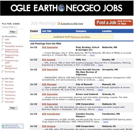
It works like this. If you have a neogeo job that needs doing, you can post it for two weeks at a dollar a day. I’ve set the price far lower than on any other job board, as I’m more interested in seeing if this takes off. (On the other hand, paying something deters spam posts.) Job-a-matic takes half of the revenues in any case:-)
The most recently posted jobs appear in the sidebar of every page of this blog, and there is also an RSS feed of new jobs. At the bottom of the RSS versions of Ogle Earth stories there is a link to the jobs listings page. Furthermore, the jobs enter Simply Hired’s database, so they also get shown on MySpace, FaceBook, etc…
Is Job-a-matic perfect? No. It currently only accepts US credit cards (Doh! They’re working on making it international, they say) and it is skewed towards the types of jobs that are place-specific and permanent, though that doesn’t prevent us from ignoring those quirks.
In the plus column, however, NeoGeo Jobs is already topped up with GIS jobs from Simply Hired’s database, so go have a look, just in case:-)
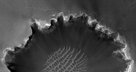
Ogle Mars
I have been spending some far too much time this past day looking intently at at the absolutely phenomenal sub-meter resolution images taken by the HiRES camera on the Mars Reconnaissance Orbiter, which are freely available for download. The full-resolution JPEG2000 files are whoppers: Some of them easily scale 250MB and half a gigapixel, so if you need an excuse to buy a new computer, this is it.
If your computer can handle them, then do spend some time exploring the library of images — it is the most impressive thing I’ve come across this year, and I’ve been making desktop backgrounds of particularly striking imagery all morning. If you’ve got a 1920×1200 screen, here are some examples (click to download):
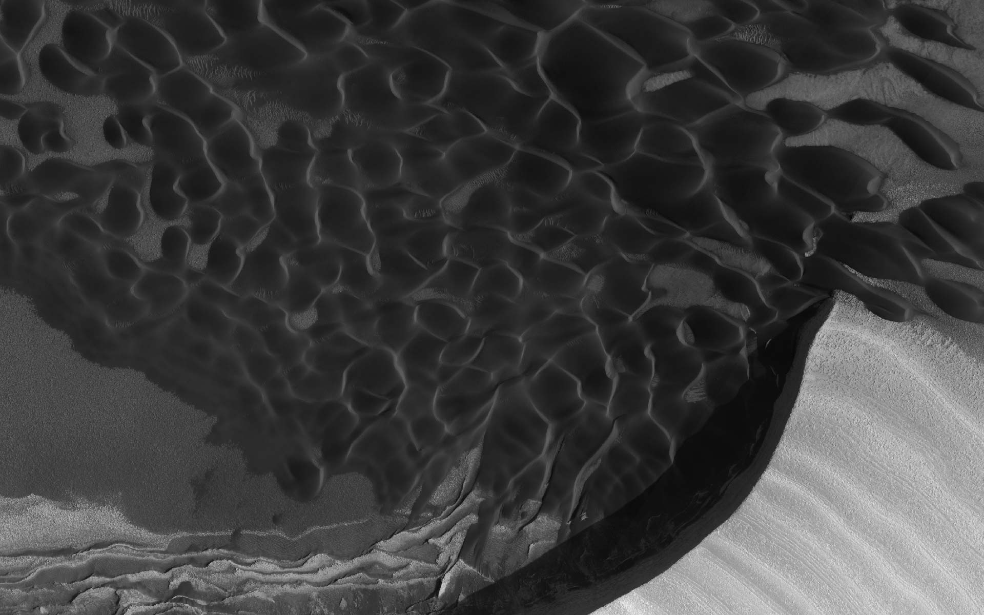
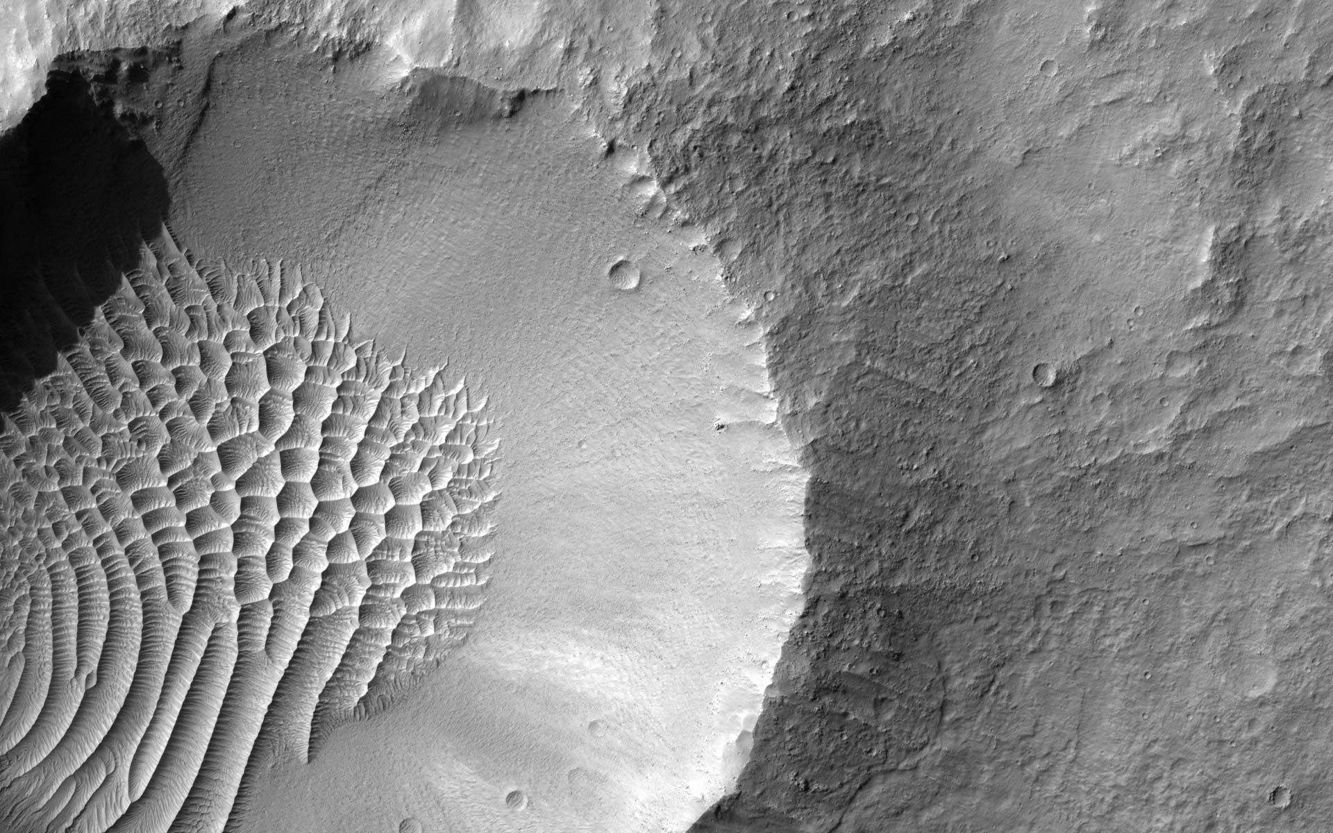
(Aside: You won’t see craters with dunes in them on the Moon because the moon has no atmosphere.)
I love it when publicly funded science makes the results available to all. And I cannot wait until this imagery shows up on a virtual globe, with DEMs — will there be a proper Google Mars, or will NASA World Wind have the plugin? (Until then, might the Maps-based Google Mars not make for a good georeferencing solution for the HiRISE image metadata?)
(BTW, Mars has a new mystery. Is this where the Martians are biding their time?:-)
Digg is dead. Long live BlinkGeo?
Digg is dead to me. It was briefly intriguing in its early, idealistic phase, but it soon got gamed, and the (mainly male) Diggers seems pathologically incapable of taking a nuanced position on anything — a position that is usually reached in error after visiting the target site for a mere few seconds, which leaves them completely oblivious to the wider context a post might have been written in.
Case in point: the digging of a recent post on Ogle Earth on the new satellite imagery showing tunneling near one of Iran’s nuclear sites. Not a single Digger managed to entertain the notion that it is possible to simultaneously hold Iran accountable for a nuclear program outside the scope of international law and also be against invading Iran. Instead, we had a conspiratorial free-for-all as to what the motivation must have been for putting those images on Google Earth. How disappointing.
That said, maybe there is a future for Digg-like sites when it comes to narrow niches, where the participants can be expected to know something of the subject matter at hand. This is what BlinkGeo aims to be for geospatial news. Let’s hope it stays relatively un-gamed, so that it remains useful. I’ve subscribed to the RSS feed.
Terraforming Mars
This is a bit off-topic, but where else to put it?
Last year, terraforming Mars was the stuff of high science fiction. This year? A recent image taken in June 2007 by the Mars Reconnaissance Orbiter (MRO) of Victoria Crater, where the Opportunity rover has been rooting around, clearly shows the rover’s extensive tracks as it explores the edge of the crater:

MRO’s photographic imagery is taken by the HiRISE camera, which has a resolution of better than 1 meter per pixel. It may be a narrow path for Opportunity, but a giant leap for mankind’s impact on Mars:-)
BTW, lots more really impressive high resolution imagery taken by HiRISE is available on their very slick redesigned site. How slick? One of their download options for new imagery wallpapers is for the iPhone.
(Currently, the Opportunity rover is battling the dust-storm of a lifetime. Check out this video. How I love the internet.)
Time-browse Earth with Terrascope
The amazing geodata portal at King’s College London, unveiled early last week, has just gotten better. First, the site’s layout has been overhauled, and a lot of the layers have been written up.
Second, a new database has been added, “the largest of all,” writes Mark Mulligan. It’s Terrascope, a planet-wide collection of superoverlays of satellite imagery from the 1970s, 1990 and 2000, so that you now really can time-browse the Earth, checking out urbanization, deforestation and other large-scale changes to the Earth’s surface over time. Here’s how Mark describes it:
Terrascope brings some history to Google Earth. Google Earth imagery is largely made up of the NASA Circa 2000 LANDSAT Mosaic (processed very well by TerraMetrics) with Digital Globe and other higher resolution imagery (largely post-2000 in origin) added for large parts of Europe and the US and for cities and other areas of interest across much of the rest of the world. I have added the public domain LANDSAT MSS Mosaic (circa 1975) and the LANDSAT TM Mosaic (1990) for most of the world. I am also running the LANDSAT 2000 Mosaic and adding that for parts of the world so that — as Google update their imagery — the following history will be visible : (all circa) 1975, 1990, 2000 and Google native (post 2000).
The aim is to help visualise land cover change in a simple way (alongside some of the other databases at www.kcl.ac.uk/geodata). The images have been converted to ‘natural’ colour. Invariably the data quality and resolution are reduced as we go back in time and some parts of the globe are missing for various reasons, including the degradation of data storage media at the LANDSAT stations, but nevertheless a useful simple visiualisation is possible.
But it’s not just data that Mark is serving, there is also metadata: Both the coverage area for each year and the metadata for individual tiles can be turned on, just like how professional geographers want it.
And there’s more! There is a database of place names added to the layer that manages to find ample names for even the smallest features in the middle of nowhere, linked to a Google search. This by itself is a great resource.
But perhaps the most innovative feature is the addition of a geowiki to Terrascope. Google Earth’s default imagery has the Google Earth Community layer to which people can post interesting finds. Terrascope comes with its own version of this, so that the exploration of the LANDSAT mosaics can be done socially as well.
The geowiki is very easy to use. Turn it on, center a location, click on the crosshairs, get whisked to a web page, fill in the details, and refresh the wiki. Done.
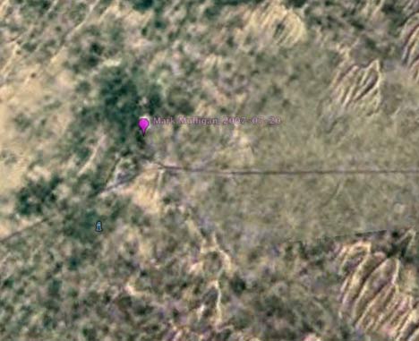
For example, Mark has pinpointed the creation of a new reservoir in Pakistan:
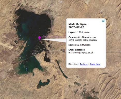
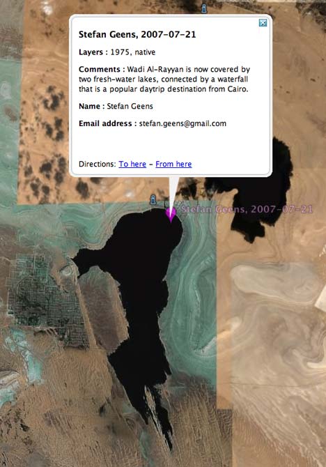
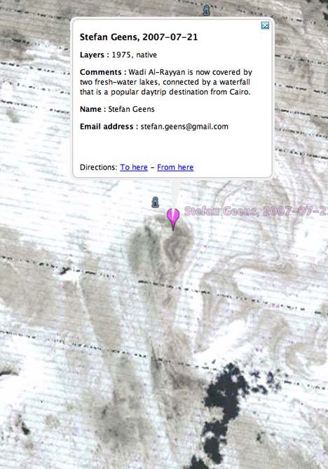
I went ahead and pinpointed the creation of two new lakes in Egypt:
Surfing through time as well as space is proving mighty addictive. Augmented reality meets Google Earth, and we get a glimpse of what future virtual globes will be doing natively.