- Future UI: Ah, more future-UI video candy. Check out Brainloop, which lets you control Google Earth with your… brain. Is this a good moment to point out that CIC Earth in Snow Crash was controlled by the brain? Brainloop’s controls aren’t continuous (yet): You use your mind to select discrete menu options, like zoom in, pan left, etc… Still, it makes for quite a performance:
(Thanks, Jonathan!)
- Where the generals live in Burma: Wow. (I can’t verify this, but it looks authentic.)
- Infrared Astronomy: Orbiting Frog builds a query for NASA’s SkyView data (containing views of the sky at various wavelengths, not just visible light) and presents it as a KML network link for Google Sky. Zoom in to a part of the sky, wait a while, and up comes the view at 100 microns, taken from the Infrared Astronomical Satellite (IRAS). He’ll make more of them if you ask nicely:-)
- Ranking patent: How does Google decide which items to show you on Google Earth when showing all of them would lead to visual overload? Well, it has a method, and the method has now been filed with the US patent office. Quote:
The system may permit, for example, bounding box queries in lat/lng space (generated by a graphical interface such as Google Earth or Google Maps), and may also prevent showing too many items, such as when a user is viewing a very large geography (such as an entire country). The system may also permit for the ranking of items so as to show them in a preferred order.
Google Earth’s been doing this sort of ranking for as long as I’ve used the application, which is why it was surprising to see others come out with patents for such methods. Back in 2005, someone in the Netherlands patented “altitude ranking”, though it was deemed trivial and not original by those in the know.
Might the same be said for Google’s patent? I don’t have the expertise to decide, and the patent document itself is not all that detailed, but Paul Ramsey thinks it isn’t worthy of a patent, on account of the innovation being “trivial”.
(Via Russell Shaw and All Points Blog.)
- Cool Blog: VRlog.net collects panoramas from the 360 Cities site. A nice bite-sized way into their collection, all of which is now linked to panoramas in Google Earth.
- MDG Monitor: The UNDP’s Millenium Development Goal Monitor (MDG Monitor) is now live. As expected, it includes a Google Earth layer that georeferences the status of the goals for each country.
- KML How-tos: Google Code gets two new how-to articles of interest to neogeographers, reports Google Maps API blog: A how-to on using time tags in KML, and another on using KML in Google Mashup Editor, by Valery Hronusov. (Via Google Earth Blog)
- Morocco and Google Earth: More on internet censorship in Morocco, including a discussion of why Moroccan authorities might have banned Google Earth.
- Old Singapore: Singeo complains the most recent images of Singapore are, well, not the most recent:-)
Category Archives: Uncategorized
Arunachal Pradesh: Indian or Chinese in Google Earth?
[Update 2009-08-09: See the new entry about the current controversy surrounding Arunachal Pradesh in Google Maps. The below was written in November 2007 and contains outdated information.]
This blog has tracked a good number of stories coming from the more shrill corners of the media in certain countries, purporting to prove how Google’s choice of borders for Earth and Maps is meant to show an intentional slight when the choice goes against their wishes. Such stories have mainly served to show how Google Earth has entered the public consciousness as a reference for such information. It has become important to set the Google record straight.
That doesn’t mean such stories can never have a justified complaint. As this piece by the Telegraph in Calcutta points out, Google Earth shows the Indian state of Arunachal Pradesh as being administered by China but claimed by India. The situation on the ground, however, is pretty much the reverse: Most of it is controlled by India, though the Chinese lay a claim to it.
Here’s the view in Google Earth:
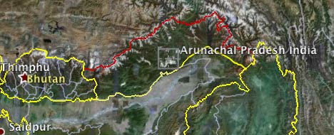
Here is the view in Google Maps:
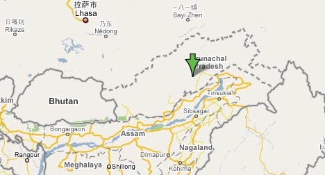
Strictly speaking, from a neutral perspective, the Maps view is correct. For Google Earth, this would translate to both borders being colored red, perhaps with an orange border depicting the line of control.
But is this coloring intentional? I doubt it. Search for “Arunachal Pradesh” in Google Earth and you will scroll to a location tagged “Arunachal Pradesh India” by Google’s own database. That’s hardly siding with the Chinese.
The article brings us another interesting tidbit, one which I’ve not seen mentioned before: The answer to the question, “How does Google decide the status of borders in disputed regions?”
“Google Earth demarcates its maps according to international standards, following the guidance of the US Federal Information Processing Standards Publication and the International Organisation for Standardisation (ISO) 3166 standards.”
I couldn’t find any actual reference maps based on FIPS, so I can’t tell if in the case of Arunachal Pradesh Google made a mistake. One possibility is that the US officially agrees with China on its claim to Arunachal Pradesh, much in the same way that the US officially agrees with China that Taiwan is part of the People’s Republic.
Media Watch: Playing the flight tracking blame game
Israel’s Haaretz has a piece out from yesterday that starts like this:
Service that allows anyone to track flights could assist terrorists
By Haaretz Staff and Channel 10
A new feature offered by Google allows anyone with an internet connection to track the flight routes of all planes arriving at or departing from the United States in real time.
For many bored surfers, this may be just another gimmick, but experts fear the new service could serve as a tool in the hands of terrorists.
That’s the introduction to a 2-minute video report that lines up a bunch of Israeli security experts berating Google for this “new feature”. (Click on the story above to see the video.)
The only problem? Nobody, not the reporter nor the experts, has any clue what they are talking about. The “feature” isn’t new, and it isn’t Google’s. It is fboweb’s flight tracking tool, available since December 2005.
This is incompetence on the part of Haaretz that borders on the unethical, as it is clearly conducive to the kind of misinformed public hysteria already evident in the comments on the piece. Next, they’ll be blaming Microsoft Internet Explorer for allowing terrorists to use chat rooms.
With all that out of the way, there is still the question: Does fboweb’s KML network links of live flight positions facilitate the work of terrorists? Such flight information is in the public domain. It takes a smart kid to write a script that scrapes coordinates on web pages and turns them into KML, so if fboweb didn’t exist, only terrorists without recourse to a geeky second cousin would be at a disadvantage. Hoping that your enemies are idiots is not the best defense… (Thanks to Jackson Pollock for the heads-up)
Virtual globe sessions at AGU listed
The American Geophysical Union’s 2007 Fall Meeting is looming — it’s on Dec 10-14 in San Francisco this year. There is a special mini website detailing all virtual globe sessions that are taking place — I count 42 presentations spread across 4 sessions (!).
I won’t be able to make it; I’ll be a the Global Knowledge III confererence in Kuala Lumpur just then, talking about public diplomacy and virtual worlds (because of my job managing Sweden’s virtual embassy in Second Life.) Who knows, maybe I’ll be able to score a cheap laptop off Nicholas Negroponte:-).
(BTW, if you visit Second Life, why not check out some virtual public diplomacy in action this coming Friday: We’re opening a new permanent exhibit on Carl Linnaeus, the famous Swedish scientist.)
UN, Google, Cisco to launch Millenium Development Goals Monitor
Remember that neogeo job advertised by the UNDP back in September for the Millennium Development Goals Monitor? Well, it’s ready to be launched. Here’s the media advisory, which begins thus:
UN, Google, Cisco to unveil online resource in the fight against global poverty
What: Press Briefing by UN Secretary-General Ban Ki-moon, UNDP Administrator Kemal Derviş, Google Chief Technologist for Google Earth and Maps Michael T. Jones, and Cisco Senior Vice President Carlos Dominguez.
When: Thursday, November 1 from 12-12:30pm
Where: Room 226, UN Secretariat
MDG Monitor is a web application that tracks real-time progress toward the Millennium Development Goals in a number of categories in nearly every country in the world. The new online resource is a one-stop-shop for MDG information and will serve as an educational and advocacy platform featuring the most current data from multiple sources in development bellwethers like public health, education and women’s empowerment.
Can’t wait to see what the MDG monitor is about? Read the job description that was advertised.
Neoconservatism vs neogeography, Syria edition
Neocon Express is quick to take credit for having found the alleged Syrian reactor on Google Earth soon after if was bombed by Israeli jets on September 6:
Not long after hearing about the Israeli raid on September 6th, I did a quick search on Google Earth, and easily found the suspected facility that was bombed (although I wasn’t sure that that was the exact facility until the images became public).
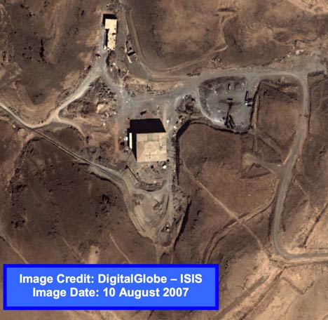
That’s quite a remarkable achievement, considering that until October 23, the imagery of the location in Google Earth looked like this:
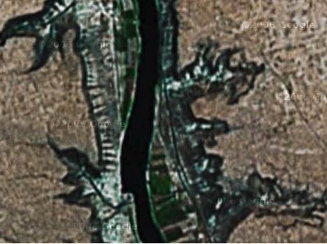
Only with the Oct 23 data update did the building become visible in the Spot Image 2.5m imagery that was added to Google Earth on that day. ISIS released its commissioned high resolution DigitalGlobe images on October 24. If you’re quick, you can still see the pre-Oct 23 imagery in Google Maps.
Then again, the neocons are so deep in denial about their failed approach to the Middle East, what difference does one more lie make?
And isn’t forensic neogeography fun?:-)
Meanwhile, in other Syria-related news:
- The New York Times carries an article showing a GeoEye image taken from September 16, 2003, showing that the rectangular structure existed then.
- ISIS releases another PDF, this time highlighting the fact that the Oct 24 imagery shows part of the mountain removed — the thesis being that this dirt was used to bury the building’s foundations.
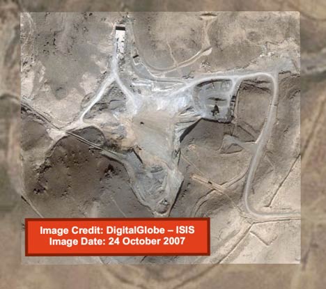
Yes, we have no nuclear reactor
Via the BBC and also the NYT this morning comes word that Institute for Science and International Security (ISIS) have released some more imagery of the suspected attack site in Syria on September 6, this time taken last Wednesday, October 24 — just two days ago.
That square building? It’s completely gone! All that’s left is scrape marks and the odd bulldozer:
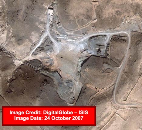
Compare to the imagery before taken before the attack, on September 6:
That just about confirms that this is indeed the spot. ISIS adds:
Dismantling and removing the building at such a rapid pace dramatically complicates any inspection of the facilities and suggests that Syria may be trying to hide what was there.
There’s more good analysis in the PDF.
I’ve turned both images in the PDF into high-resolution KML overlays. Get the KML file here. The August 10 layer is turned off by default, but turn it on and play with the opacity sliders to compare before and after imagery, as well as with the Spot Image base layer in Google Earth. Images don’t match up exactly because they were taken at oblique angles and are of hilly terrain.