Category Archives: Uncategorized

Google’s Android: 3D globe but no Google Earth (yet?)

Four minutes into this demo of Google’s Android mobile platform, you get to see a 3D globe that you can spin by dragging your finger across the touch screen:

globeandroid.jpg

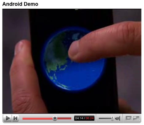
But it’s not Google Earth; it’s an application that the presenter, Steve Horowitz, calls “global time”, presumably because it can show you what time of day it is on different parts of the planet. I bet this is what the New York Times supposed was Google Earth, and it is certainly what Robert Scoble erroneously refers to as “a Google earth map” in his post about that video. (Still, if he hadn’t called it that, my RSS reader’s filters wouldn’t have picked it up, so I can’t complain too loudly:-)

Horowitz says the spinning globe was written using Android’s built-in support for integrated 3D graphics if the device has it — and a bit later he is showing us a version of the first-person shooter Doom. The demo hardware reference device on which he shows both the globe and Doom is a bit bigger than an existing mobile phone, though.

Two things come to mind:

  • Built-in support for 3D graphics on a mobile device running Linux makes it quite likely, I imagine, that we will eventually get a version of Google Earth. If the much-ported Doom can run on it today, it’s only a matter of time before Google Earth and Second Life (which also comes in a Linux version) are running on it. Now there’s a scary thought: Playing Second Life continuously from anywhere and anytime in your first life. (And imagine the things you could do with it if such a device were to have motion sensors:-) I wonder if this will be the start of mobile phone devices encroaching on Sony PlayStation PSP’s market segment.
  • In the demo, the “global time” application is not shown being zoomed in. But even if it can do so, props should go to Swedish company Wayfinder for their visionary zoomable globe/map hybrid that launched in May 2006. Watch the 90-second video demo of Wayfinder Earth here. Wayfinder’s Earth is 2D masquerading as 3D, of course, but as long as true 3D isn’t feasible on truly mobile phones, that will be the way to go.

A bit later in the video you also get to see a demo of Google Maps that looks very similar to how it works on the iPhone, although the Android version has support for Street View, and you can scroll and zoom the panorama using touch-screen gestures. I’d be surprised if that doesn’t come to the Apple iPhone soon, as it is the obvious enhancement to Google Maps on a touch screen.

I’m surprised how far along Android is on the demos. It is quite similar in aesthetics and functionality as the iPhone, I feel, which to me suggests that Android and iPhone will be setting the benchmark in 18 months time. Those mobile operating systems that do not by then support touch-screen pinching and liquid graphics will be history.

The default layer update: The good, the bad, and the ugly

Well, you’re in luck: I DO have value to add to the news of today’s default layers update in Google Earth, so in keeping with my freshly articulated blogging priorities, it is getting an own post. (Enough with the metablogging already – Ed.)

If you fired up Google Earth today you will have noticed the substantially reorganized default layers sidebar. Quickly now: There is a new live weather layer showing global cloud coverage, US radar imagery and forecast data from Weather.com; layers are reorganized thematically; and I’m pretty sure that the Egypt Tourism layer in the new Travel and Tourism folder is new.

So, what’s the good in this update? The weather layers are the first of their kind to be dynamic. As Google Lat Long Blog tells us, they are constantly updated, not once a month or thereabouts as was the case until now. It is my understanding that this dynamism extends to all default layers — so no more need to wait a month for an update… at least not for technical reasons. The contributors of the default layers can now, if they want to, publish straight to Google Earth, just like Weather.com does.

What’s the bad? I’m no fan of the new Egypt layer. It’s promotional, rather than informational. The 100% New Zealand tourism layer at least has a feeling of being exhaustive when it comes to cataloguing that country’s cultural and natural heritage. Not so with Egypt’s layer. And it is a pity, because the country is bursting at the seams with archaeological and natural treasures. Instead we get (I can hardly believe it) a placemark for Hurghada! Seriously, wouldn’t you rather not know the following? From the popup:

A simple fishing port just a decade ago, Hurghada is now the most popular seaside resort in the world for sun worshippers, water-sports enthusiasts and divers. With its modest souk, the town centre, known as el-Dahar, has retained its traditional charm. Tourist resorts – of which there are over a hundred, many of them boasting ultra-luxurious accommodation – extend for 20 kilometres or so along the coast. Few of the coral reefs can be reached by swimming from the shore, but numerous clubs and tour operators offer excursions out to sea; the island reserve of Giftun is well worth a visit.

People! — it’s a tacky tourist trap. Cairenes roll their eyes at the mention of the place. Meanwhile, there is no placemark for Whale Valley or Abu Mena, both on UNESCO’s World Heritage list. And Egypt’s Supreme Council of Antiquities has the entire country’s historical patrimony in a GIS system, a dataset so deserving of wider popularity but without the will or funding (or a clue) about converting to neogeographic formats.

I’m wondering if such layers are there purely on their merits, or whether they are a revenue generator for Google. If they are, I think we should be told that we’re navigating a geo-infomercial. If they aren’t, I’m wondering if all comers are allowed… Perhaps this is the reason why we now have a separate tourism folder.

The Ugly: The weather forecast layer (currently down due to heavy server load) shows both a weather icon and a temperature — but the temperature looks like this: “75ºF – 22ºC”. That is an inefficient way of imparting information, as one half of it is redundant. It is the equivalent of showing a placemark with two labels, one in a language you don’t care for. What I impulsively felt like doing was removing the Fahrenheit number — except that you can’t.

I’d prefer just getting the temperature in Celsius, either via a preference setting (just as you can determine metric distance units instead of imperial units in the preferences) or else by letting us toggle between two separate layers.

There you have it — the good, the bad and the ugly of the latest default layer update.

Metablogging interlude

Before we get to the day’s news (in the next post), do excuse this following bout of metablogging.

What is this blog good for? It’s a question I like to ask myself constantly (on a “know thyself” basis). Over the past 28 months, the answer has shifted, as it should. When Ogle Earth started in July 2005, Google Earth was a week old. Neogeography wasn’t yet a neologism. The premise of this blog was that the advent of geobrowsers would radically change how we navigate information. Charting that course was a personal interest, but as the popularity of this blog indicates, it has proved to be a widely shared interest.

But it is still a personal interest, and such interests do shift. With geobrowsing going steadily mainstream over the past 2+ years, I’ve become less interested in writing about geobrowsers than about their wider effect. The minutiae of successive feature updates are not in themselves all that interesting for me to blog, especially now that you can get that information from the horse’s mouth (as it should be).

By analogy, while it would have been very interesting to read a blog about web browsers back in 1994, I certainly wouldn’t do so now. While it was interesting for me to organize a conference for Swedish bloggers back in 2004, it wouldn’t make any sense now, when blogging is ubiquitous in Sweden. It would be like organizing a forum for television viewers:-)

So what is Ogle Earth good for now? This blog has had to compete for my attention with an ever-growing list of projects — ironically, many of them the result of this blog. I am going to spend less time on news and more time on analysis pieces. Sure, news still matters, and I read a whole lot of it, but if I don’t have any value to add, expect to see it mentioned briefly and in a not particularly timely manner in a grouped links item — even if it is big news. That’s pretty much like how this blog’s been written over the past few months anyway — but now it’s official:-)

How geosavvy is Mac OS X Leopard?

Are you wondering what the photo georeferencing “feature” in Mac OS X 10.5 Leopard is like? Find a photo that has latitude and longitude already encoded in its EXIF metadata. Open it with the Preview Application, turn on the inspector, and voila, under the “More Info” tab you get the metadata above a small world map:

xfds.jpg

You can’t edit the GPS data, and the built-in map is about as rudimentary as you can get, but the Locate button takes you directly to the view in Google Maps in your web browser. That’s a smart bit of outsourcing, but it’s not as if the third-party photo georeferencing tools currently running on the Mac are in any danger of being outpaced by the operating system. And it’s also a bit curious that neither iPhoto nor Aperture have a built-in mapping solution in a time when photogeoreferencing has gone mainstream. HoudahGeo, GPS Photo Linker, Geotagger, PhotoInfo and LoadMyTracks have nothing to worry about.

Links: Extra-solar planets, OpenSocial multi-user Google Earth, World Bank goes neogeo

NYT: Google Earth to run on Google’s mobile platform!

When the Apple iPhone came out, we were told it ran on a variant of OS X. It was only natural to speculate whether it might not run Google Earth. Now Google has released the specs for Android, its mobile platform, and we are told it will run on a variant of Linux. Google Earth also runs on Linux, so do we need to start speculating whether Google Earth will run on Google-platform mobiles?

No need! The guy behind the platform, Andy Rubin, has just shown the New York Times a version of Google Earth running on a mobile device:

A brief demonstration of the Google software recently suggests that phones made using the technology will have features and design similar to the Apple iPhone. Mr. Rubin demonstrated a hand-held touch-screen device that gave an immersive view of Google Earth, the company’s three-dimensional visualization software.

Mr. Rubin, who is 44 years old and is a veteran Silicon Valley designer, said the software system that Google has designed is based on the Linux operating system and Sun Microsystems’ Java language. It is designed so programmers can easily build applications that connect to independent Web services.

As an example, Mr. Rubin said the company’s StreetView feature of Google Maps could easily be coupled — mashed up, in technology speak — with another service listing the current geographical location of friends.

That’s awesome! Okay, some caveats: “hand-held touch-screen device” could be something quite large, more like a car satnav device, in which case it wouldn’t be that special, as we’ve seen such prototypes before. And I wouldn’t put it past a reporter to confuse Google Maps for Google Earth (though John Markoff is tech-savvy).

Oh, and social APIs released last week, collectively called OpenSocial, are GeoRSS-savvy, discovers The Spatial Miscellany. Here’s the direct link to the Google Code reference, via Jason Birch. (Thanks Avi for the heads-up.)