- Google Earth and mainstream consciousness I: Ubikcan flags a recent Doonesbury cartoon by Gary Trudeau highlighting the use of Google Earth to track human rights violations.
Ubikcan highlights to another one from the New Yorker a few months ago that I had not previously noticed. And while we’re on the topic, let’s not forget one of my all-time favorites, the Ogle Earth cartoon in the New Yorker from 2006?:-)
- Google Earth and mainstream consciousness II: Sydney art collective The Glue Society produced a work that consists of retouched satellite imagery to depict biblical mythology. Says Glue Society’s James Dive: “We like to disorientate audiences a little with all our work. And with this piece we felt technology now allows events which may or may not have happened to be visualized and made to appear dramatically real. As a method of representation satellite photography is so trusted, it has been interesting to mess with that trust.” Click here to see their work as depicted on Creative Review’s blog.
- Mapping in the dark: What about using maps in the dark, for example when driving? IDVUX blog discovers a genial solution — run a color-inverting filter on the client side:
- KMLer update: The latest version of Valery Hronusov’s KMLer 2.0 ArcGIS extension for Windows supports extended data fields. ($20-$50)
- Mac geocoding I: Mac photogeoreferencing tool HoudahGeo is up to version 1.3. ($25)
- Mac geocoding II: SnapMap is an upcoming application for representing your photos in 3D and across a timeline. There’s a video demo, and they’re looking for beta testers.
- Dedicated IGC viewer: For hang-gliding Windows users with .Net installed, a tool for replaying your flights’ IGC files that has dedicated controls and views that uses the Google Earth engine. This thread on OZ Report discusses the application. (You could also use a web-based IGC-to-KML converter or IGC2KML. (the latter comes recommended by OZ Report’s Davis Straub.))
Category Archives: Uncategorized
Google Sky API: Early usage examples
Google Maps’ API now officially supports Google Sky imagery. HeyWhatsThat takes quick advantage of this to make a planisphere tool for the web. Alasdair Alan ar The Daily Ack, meanwhile, spends a productive weekend playing with the API to 1) make it compatible with PLASTIC, an emerging protocol for communiication between astronomical applications, and 2) make it work on the iPhone. All very impressive!
[Update 2:40 UTC: The possibilities are only just now beginning to percolate through: In a few months, when the iPhone SDK comes out, why not view astroreferenced news on your iPhone with Google Sky, and then (here is the cool bit) control your telescope with the iPhone to get it to view the location in question automatically!]
Antarctica: Start adding content
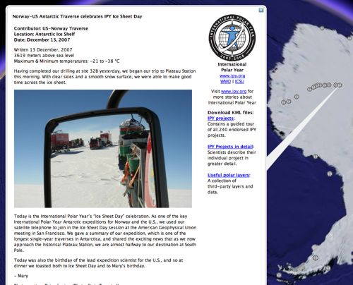
The most recent imagery update for Google Earth now includes the recently released 15-meter resolution LIMA imagery for much of Antarctica. Antarctica is looking pretty empty right now when it comes to default layers, but if you download the International Polar Year website’s KML layer, you can get daily updated georeferenced posts from scientific expeditions on Antarctica, including from the Norway-US Antarctic Traverse, which is currently on its way to the South Pole. Soon the layer will also include georeferenced posts by the research ship Polarstern, so keep that layer handy!
Intel Classmate gets the map test
Back in June I had a chance to play with the One Laptop Per Child (OLPC) computer, and used the opportunity to check out which mapping sites worked on its browser. (Google Maps and Yahoo Maps Classic worked, Microsoft Virtual Earth did not.)
In the past few months, Intel and Microsoft have been touting a competitor, the Classmate, which runs Windows XP. Intel and Microsoft, both big sponsors of Global Knowledge 3 here in Kuala Lumpur, were showing off Classmates. I got to play with one. I’m sure you’re dying to know — does it run Google Earth? Virtual Earth in 3D?
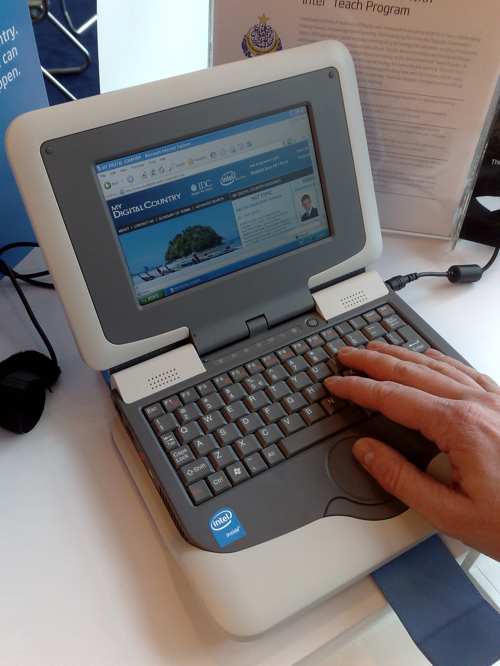
I like the look of the Classmate. It is small and feels rugged. Spec-wise, Classmate and OLPC are similar in terms of RAM and NAND flash storage, but the Classmate suffers from a really small screen — 800×480 pixels (color). OLPC gets 1200×900 pixels (color).
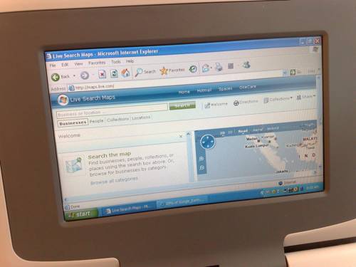
Because the Classmate runs Internet Explorer on Windows XP, all the mapping sites loaded, though in all cases, the small screen meant that the actual map area of the web page was miniscule.
I installed Google Earth — the process went without a hitch. How does it run? As expected, because classmate has no graphics card, frame rates were very low:
As for Microsoft’s Virtual Earth 3D, i never got the installation process to finish. Of course, it was very unfair of me to try this on a sub-$300 computer, but one can live in hope:-)
Which laptop will be more successful? I suspect that the developing world’s government education agencies will likely go for the Classmate because of the familiar Windows on it. Children, on the other hand, will care more about the cool screen. One BBC reporter who has been skeptical of the OLPC found that his kid loves the OLPC. Also, at half the price, you get more OLPCs than Classmates for your money, though you could also just wait 18 months for Moore’s Law to do its thing. In the end, it’s the OLPC that wins my heart, as it is such a radical departure from traditional laptops.
Links: Google Earth patent, Outreach showcase, Dagik
- Google Earth patent: ZDNet’s Russell Shaw unearths (ha) a recently published patent application by Google that details how Google Earth does what it does, particularly over on the server side. The application was filed April 25, 2006, and published Dec 6, 2007. I eagerly await Avi Bar-Zeev’s exposition of What It All Means.
- Outreach showcase: Google Earth Outreach gets its own showcase. (Via Google Lat Long blog)
- Daily geospace data as KML: Kyoto University’s Dagik. Wow. Quite a resource.
- GIS for development: Over at Global Knowledge 3 I ran into the Canadian developers of the ICT4D Atlas, an open-source map-and-database tool that lets you add georeferenced information (at the country and city level) and then perform basic analysis on it. The idea is to develop this into a fully fledged tool to help development projects. It’s a work in progress, but worth mentioning here in case others in this space might want to collaborate. (The developers are active on PPGIS.net, a mailing list for participatory GIS technologies that I was not previously aware of.)
- AGU: Google Earth Blog‘s Frank is covering AGU’s fall meeting.
Earthmine: From stereo panoramas to an annotatable 3D city model
Earthmine is a competitor to Google Street View that was last blogged here in October. At the time, we noted that Earthmine turning automated city panoramas into an annotatable background canvas really is the state of the art. We even dared hope for some kind of vague far-off future where it is possible to “paint panoramas onto a very accurate 3D rendering of the world, so that every spot in the panorama and its corresponding coordinate on Earth become one.”
Fast forward 70 days. It would appear that Earthmine has done just that. Here is a video of their upcoming mapping product that is definitely worth watching:
The best part: They’ve licensed the technology behind software used by the Jet Propulsion Laboratory’s Mars Rover team which turns a series of stereo imagery into 3D terrain that mission control can then use to steer the rovers.
(Plenty of 3D Mars data sets made with this software were released to the public together with a viewer back in 2004, and it was easily the coolest thing my Mac did that year. That viewer, Maestro, and the datasets, are still available for download today. A must if you haven’t already. Earthmine, now that you have the technology, is it too much to wish for Marsmine? Just the bits where the rovers have been will do…:-)
Only bummer: Earthmine is Flash based, and Apple isn’t doing Flash on the iPhone.
Ordnance Survey OpenSpace: DOA
“UK’s Ordnance Survey has released (a closed alpha of) OpenSpace, an API for their maps! I’ve been wrong to criticize them for their paleogeographic ways when all along they were stealthily working to embrace us neos.”
That was my first impression when I read Ed Parsons’s announcement of the news. But Ed’s post also mentioned something about tile limits, and from the Guardian I learn that this API project is something “urged” onto the OS by the UK government’s Cabinet Office.
Time to dig a bit. And that’s when we go from the sublime to the ridiculous. From their FAQ:
1.4 How much data am I allowed to use?
OS OpenSpace allows your API key to access up to 30 000 tiles of data and up to 1 000 place name look-ups per day for free.5.4 My site gets a lot of traffic, what can I do?
Congratulations :! Contact us to talk about the different possibilities we may be able to offer you. If you are interested in commercialising your application, take a look at point 6.2 of the FAQs.
So let’s say I add an embedded OpenSpace map to a blog post on Ogle Earth that shows 9 tiles. That should last me about the first 12 hours of every day. Sorry late-rising Californians, my quota is up! Should I add two such maps within 15 posts of each other, so that the front page of the blog displays a total of 18 squares, then Europe is out of luck too. Translation from OSese: Feel free to have a website that uses our maps, as long as it is obscure and unpopular.
Oh wait, there are licensing options available to those with sites that get “a lot of traffic”. But they are in dense legalese and for “businesses” and “value-added products” and “branded published products” with “royalty models” and “product schedules”… Dudes. I’m a blogger. WTF? Are we really all supposed to call you to find the price?
6.3 Can I have adverts like Google Ads on my website? (Is it only on the same page as the map or the whole site?)
No, please see the OS OpenSpace Developer Agreement (there can be no form of financial gain).6.4 Can I build an application for Facebook/MySpace/any other commercial website?
The application you build cannot result in any financial gain to you (the developer of the application), the user or any other party; please see the OS OpenSpace Developer Agreement.
Well, which is it? “Only on the same page as the map or on the whole site?” Does anyone know? Did someone copy-editing the FAQ write that and accidentally leave it in? Not that it matters; whatever the answer will be, this is so stupid and tone-deaf to the realities of Web 2.0 that I’m practically sputtering into my Malay gin & tonic. Pages and websites are artificial constructs in Web 2.0, as we’ve now all moved on to services aggregated from wherever they may originate. Do I really have to set up an ad-free www.NotOgleEarth.com and link to maps served from there as popups or iframes every time I want to use OpenSpace? Is OS not aware that advertising such as Google ads is ubiquitous on the blogs and hobby sites that the OpenSpace API is ostensibly for? For the overwhelming majority of bloggers — certainly those for whom 30,000 tiles per day is plenty — the ads at most help defray hosting costs, or else they are injected by web hosters to pay for free hosting services. Does the Ordnance Survey really think all these people are going to remove their Google ads from an entire site forever (or switch provider) if they once used OpenSpace to show their favorite route to work in a blog post now buried somewhere deep in the archives?
Mapperz, in his wonderfully efficient telegraphese style, has some further observations:
Note: Any Content you create using the Open Space API – Will not be yours, as it is ‘dervived’ from Ordance Survey Products. […]
No 1:25,000 (Explorer range) or 1:10,000 Rasters
OpenSpace will not be used by anyone. With the current restrictions it is dead on arrival. Perhaps that was the intention?
[Wait, the Developer Agreement has more:
2.6 The Website is provided for Use by private individuals strictly for the Purpose. You may not use the Website, the Ordnance Survey API or the Ordnance Survey Data or any part thereof in connection with any other purpose.
“Purpose” means any purpose or activity which (i) is not undertaken for Financial Gain; or (ii) does not result in Financial Gain to you or any User or any third party used by or in connection with you or any User; or (iii) is not connected to any company, partnership, sole trader or other business entity or professional body, any educational institution, or any central or local government or other public sector body; excluding for the express avoidance of doubt use in relation to any website that carries paid for advertising, and/or use by the afore-mentioned entities in their day to day activities, on their intranet or in connection with any display, promotion or advertising;
So does this mean that other people can link to the free popup OpenSpace maps on NotOgleEarth.com, but not me from OgleEarth.com? Or can you link to them only from sites that themselves do not have ads? What about sites that link to those? Is this a nefarious plot to rid the world of Google Ads by someone somewhere on the web linking to a single OpenSpace map?:-)]