Category Archives: Uncategorized

What if New York had the world’s tallest building?

How would New York’s skyline look if it once again held the world’s tallest building? It’s a question I’m sure many New Yorkers have asked themselves. I know I have.

New York hasn’t been home to the world’s tallest building since 1974, when the title went from One World Trade Center to Chicago’s Sears Tower. Since then, it’s shifted to the Petronas Towers in Kuala Lumpur (undeserved, in my view — anyone can add a spire) and subsequently to Taipei 101. Currently under construction is the Burj Dubai, which will be at least 700 meters tall when completed in 2008, easily making it the tallest structure anywhere.

Freedom Tower is set to replace the World Trade Center, but it has received plenty of negative criticism for its uninspired design. What if…

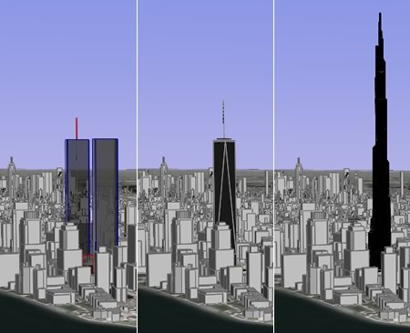
With Google Earth, what-if scenarios are easy. The application already supplies a layer of existing buildings for New York City. Just add your own. Here’s some comparison views of the WTC, Freedom Tower, and Burj Dubai:

compareGE.jpg

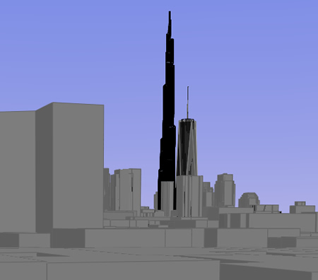
Here’s what Freedom Tower and Burj Dubai would look like from the roof of my ex-apartment in the East Village:

viewnewGE.jpg

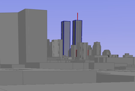
It’s remarkable how accurate Google Earth’s base layer is. Here is the view from the same roof up until September 11, 2001:

109viewGE.jpg

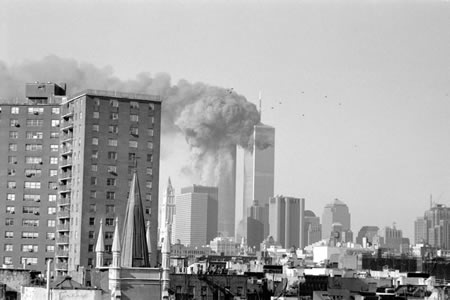
Compare it with the photo I took that morning as the towers burned (complete series here):

109viewRE.jpg

Here is the KMZ file (580k) containing all the content for this post, so you can try out the view from your own vantage point. Credit for the Burj Dubai goes to ZNO blog. Credit for Freedom Tower and WTC models: Equitus.

(Technical details: I had hoped to import Burj Dubai into SketchUp and then export it to elsewhere on Earth, but the Mac beta of the Google Earth plugin for Sketchup proved a bit too buggy. Instead, I opened the KML file in a text editor, and then did a search and replace on the most significant digits of all the coordinate pairs. It worked beautifully, though there is one caveat: The physical distance separating units of longitude depends on the latitude. Dubai is at 25 degrees north, where 0.1 degree of longitude spans 10km, whereas Manhattan is at 41 degrees north, where 0.1 degree of longitude spans 8.45km. So the model of the Burj Dubai used for this post is actually 15.5% too narrow, east-to-west.)

Google Earth, enemy of football

You can’t make this up. German news site Heise Online is reporting that:

In the opinion of the security expert Klaus Dieter Matschke the coordinates supplied by the program Google Earth pose a security risk to the Soccer World Cup hosted by Germany. […] The precision of Google Earth entailed the risk of handing terrorist groups precise target coordinates for possible missile attacks, he warned.

Apparently, Germany’s publicly available coordinates are only accurate to a kilometer. Matschke clearly thinks anyone can get access to missiles, whereas GPS units and tourist maps are hard to come by. Now that Google Earth obviates the need to spend 2 minutes acquiring accurate coordinates, the world is in danger. Bad Google Earth!

Christian Spanring’s commentary gets it exactly right:

So if we are confronted with security issues based on public geographic information, what should we do? Forbid and ban every kind of GIS and accurate map except for authorities (and security experts of course)? Oh wait, it reminds me of something: can it be that less censorship, better public information and knowledge within countries and governments is, let’s say, an improvement that came along with democracy and modern society?

How do people like Matschke, who really should know better, manage to reach such outlandish conclusions? (Original article in German.)

New things: 3pointD, TopoNorte, Norway cheats too

Yes, we have no Swedish spy base

Following up on the story earlier today of camouflaged censorship on official Swedish aerial imagery…

Swedish secretiveness evidently runs shallow. Another Swedish blogger has discovered that on State GIS agency Lantmäteriverket‘s own website, if you want to purchase aerial photography of Sweden, it is quite happy to let you try before you buy an uncensored image of the spy base that is censored in the publicly available data. And at higher resolution too:

relant.jpg

Obviously, one end of Lantmäteriverket hasn’t got a clue what the other end is up to. Perhaps they could use a better map? Arrogantly justifying the need to censor (as a spokesman did in various interviews with the Swedish press) only to have the back door wide open proves that these excuses were made up, an expediency to keep us proles happy.

Sweden plays hide and seek with maps

Sweden’s Lantmäteriverket, the state GIS agency, has been caught camouflaging its censorship of the country’s spy headquarters on aerial images it makes public, and Google Maps is directly responsible for the find.

It started when Eniro, a mainstream search and mapping site for Sweden, decided to use Lantmäteriverket’s images to add aerial shots and hybrid maps to its mapping service, much like Google Maps does. A publication eventually noticed that the aerial data provided by Eniro and Google don’t match in a special spot on the outskirts of Stockholm. Here is Eniro’s image:

eniro-bild.jpg

Google’s image:

eniro-bild.jpg

What’s even more absurd is that Eniro’s mapping service actually has the roads and buildings, so the hybrid image looks like this:

eniro-bild.jpg

(Incidentally, Google Maps and Google Earth don’t have the same dataset for this location — Google Earth’s has a random cloud covering the crucial spot.)

It turns out that Lantmäteriverket employs a person whose job it is to camouflage its censorship by painting over buildings with trees and fields. The story made it to Sweden’s lagest tabloid on Thursday in mangled form (of course), as blogged by Patrick Strang (in Swedish). Strang also rightly points out that the only effect of such camouflaging, where you are lied to about the true information content of a map, is to distrust all maps by the same source, in this case Lantmäteriverket. It makes these maps less than useless, especially when Google Maps and Earth is around. And it is behaviour unbefitting an open society. If you need to censor something, fine, but don’t hide the decision. That way lies 1984.

Another interesting tidbit: The agency said it does not have a problem with Google’s images, as they are satellite-based, and hence outside the jurisdiction of Sweden, whereas the images it can censor are taken from planes that fly within its jurisdiction. Countries do indeed have a monopoly on sovereignty in the air, and not in space.

(Early datasets for Google Earth also used images of the White House where censoriship by a US agency was camouflaged, as blogged here.)

[Update 2006-04-10: There’s two further updates to the story, in the meantime: Yes, we have no Swedish spy base and Sweden: Watching the watchers (with Google)

Discovery Channel deal gets mainstream media play

The Wall Street Journal has an article today about the new Discovery Channel network link for Google Earth, as does the Washington Post. It’s clear (from Ogle Earth’s visitor stats, at least) that yesterday’s content announcements are driving a major boost in downloads of the Google Earth client. Both these articles should further push along the mainstreaming of Google Earth, slowly turning it into an application you can assume has been installed on a PC. Everything is going according to plan:-)

The only thing that’s lagging perhaps is mainstream reporters’ understanding of what precisely is going on when the Discovery Channel announces “availability of Discovery’s world-class video content on Google Earth”. Here is WaPo:

Over the next few weeks, Google’s program will begin including a globe icon, linking users to a series of two- to four-minute videos from Discovery’s archives.

Not quite. As the WSJ reports, you currently download a network link static KML file with 10 tagged locations manually, but it will soon be available as a default layer, just like National Geographic’s Africa content. Meanwhile, the WSJ is a bit too enthusiastic:

The feature, which marks the first time that Google has promoted video content on Google Earth…

Google’s promotion of National Geographic’s content about Africa, including video, in fact came first. But both articles do add information: Neither side in the deal is sharing revenue — instead, Google Earth gets the market penetration, while the Discovery Channel website gets traffic it can monetize.

Something else worth pointing out, perhaps: The videos are not “on” or “in” Google Earth in the sense that the application hosts or streams the content. An ordinary network link leads to the Discovery Channel’s site, where the video is streamed; Discovery Channel bears the bandwidth burden. For Google, this promotion involves minimal effort.

Newsflood: Bird flu update, Belgeoblog, how to run Google Earth on Linux