Category Archives: Uncategorized

Google Earth 4.0 beta, part 2: Support for Textures

Part 1 of coverage introduced the new GUI. Here’s continued coverage…

transam.jpgIn the meantime, Google’s official beta 4.0 page is up. Major news on that page: SketchUp models with textures are now supported in Google Earth. Now the “Add Model” menu item makes sense:-)

Also, KML loading has been improved, so that only those areas that are needed are rendered, increasing speed.

There are now localized version of Google Earth, in French, Italian, German, and Spanish. GPS support has been improved. And “We’ve improved the terrain, so peaks and valleys are more realistic”.

Google Earth Blog is reporting live from Google’s Geo Developer Day, meanwhile. Wish I was there:-)

Meet Google Earth 4.0 beta

Google Earth version 4.0 beta has just been announced at Google’s Geo Developer Day today. Just go and download it and play, or if you’re stuck at the office, read on…

First, the basics:

What’s new:

The look and feel of Google Earth for Windows and Mac has been greatly improved. (I don’t have access to a Linux machine so can’t report on that version, sorry.)

  • There is far more efficient use of screen real estate. The controls at the bottom of the screen have been replaced by a transparent “navigator” in the top right corner, which turns from a compass into all the controls you need when you mouse over it. You’ll need to change some of your habits, though, Tip: double click on the”N” at North to reset the direction.

    navigator.jpg

  • There is a very narrow toolbar along the top of the screen, with the most common tasks. These include Add Path and Add Polygon, which are Plus-only options.

    toolbar.jpg

  • There is now a scale legend. It gives you a better idea of scale than guessing from the eye altitude indicator you used previously.

    scale.jpg

  • Gone are the slightly garish primary colors that served as title bars for the Places, Search and layers tabs. In both Mac and Windows, they’re now a cool gray. Buttons are much cooler as well.
  • A lot of the keyboard shortcuts you may have used have been changed. Toggling the sidebar on and off is now Command-Option B, instead of Command-2. A new placemark is Shift-Command P, instead of Command-Nl. It makes more sense, but again, you’ll need to change your habits.
  • You may already have noticed that the contents of the Layers tab have been rearranged as of earlier today in the 3.0 Google Earth. (See Google Earth Blog’s post.) The tab itself now has a further refinement: You can select which layers to make visible, like so:

    layers.png

  • In the Preferences/Options pane, you can now also tweak “Terrain quality”. It changes the number of polygons that are rendered. More polygons = smoother terrain = more processing needed.

What’s still different between the Mac and Windows version?

  • The Mac version still doesn’t support a built-in browser.
  • The Mac version doesn’t have a full-screen version (F11 in Windows).

Other nice new things:

  • When selecting a placemark, you have far more control in choosing how the icon looks. You can choose plenty of icons easily via a popup menu, and you can choose color and transparency for both the icon label and line (to Earth, in case the placemark is in midair.)
  • Importing a SketchUp model now looks far easier, with a dedicated menu item for doing so.
  • In the Prefences/Options, you can choose whether the translucent “navigator” controls are always on, off or appear on mouseover.
  • Google Earth asks for usage statistics. You can turn this on and off in Preferences/Options.

More to come…

Norwegian military gets upset at Google Earth Community post

We all saw this coming as early as January, though maybe not from Norway… Information posted to Google Earth Community (GEC) has been deemed too sensitive by the Norwegian Armed Forces… or at least that is what a spokesman said on the record after a local newspaper called for a comment a few days ago.

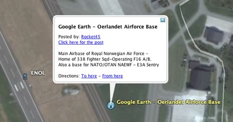
The paper, Adresseavise, had pointed out to the spokesman that not only was one of Norway’s most imporant military airbase shown in high resolution in Google Earth, a user, Rocket45, had annotated the place with the following on Google Earth Community:

Main Airbase of Royal Norwegian Air Force – Home of 338 Fighter Sqd-Operating F16 A/B. Also a base for NATO/OTAN NAEWF – E3A Sentry

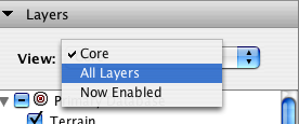
This was published in October 2005, 8 months ago (!). Turning on the GEC layer in Google Earth produces this:

oebase.jpg

My Norwegian isn’t great, but the gist of the response by Morten Rosenlund, the spokesman, is clear. He first says that because Norway is a signatory of the Open Skies Treaty, Google is indeed allowed to display high resolution aerial imagery of the base… (but fails to notice that the imagery is from a DigitalGlobe satellite, not a plane, which means the treaty is irrelevant in this case). Rosenlund then claims that the treaty does not allow the publication of sensitive information about restricted bases, for example by annotating an image on the web. Adresseavisen reports that Rosenlund then contacts the military security services to alert them of this “breach” and quotes him as saying that such leaks are punishable by a year of jail under a secrecy law from 1914.

The story soon spreads, and makes to to a Norwegian tabloid and an IT publication. Both headlines read “Military wants to stop Google”.

Where does this leave us now? Where does this leave Google? Might the Norwegians try to get Google to reveal the identity of Rocket45?

It will probably never get that far. More likely is that spokesman was merely being overly officious in his duties, and that higher-ups soon realize there is nothing there that isn’t publicly available elsewhere — GEC commenter Jan Krogh points out, for example, that the same information about the NAEWF AWACS can be found on the Royal Norwegian Airforce’s own website.

But who gets to decide whether information is sensitive, secret, or even a danger? Google all by itself? Any country who feels exposed? A US court? The Pentagon? These are the risks you run when you host the whole gamut of the public’s expressions. One person’s transparency is another’s treason, clearly.
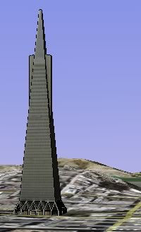
Watch Eames’ Powers of Ten

On YouTube, Powers of Ten, Charles and Ray Eames’ video for IBM that is sometimes quoted as an inspiration for Keyhole’s Earth, now Google Earth.

I myself never saw this as a child, but our family’s atlas had something similar in its introduction, and it left quite a deep impression on me. That and legos formed me, really:-) (Via Kottke)

Update 13:26 UTC: Here‘s the exact location of the picnic.

Friday roundup: Blogger meetup at Where 2.0, GeoRSS scuffle, “paid placemarks”

  • Are you a blogger attending Where 2.0? Here is your meetup, time and place TBA, put into motion by Fantom Planet.
  • This is a wonderful overlay, posted to Google Earth Hacks: How the continents looked during the Late Cretaceous period, around 65 million years ago, when the dinosaurs suddenly became extinct. Turn on borders in Google Earth, and you have an instant comparison with how the continents look now.
  • Apparently, this is the location in Iraq where Al Zarqawi was succesfully targeted, as shown on the video release by the US military. It looks similar, but I can’t tell for sure.
  • A press release by Cambridge UK company The GeoInformation Group announces the availability of its 3D buildings data as KML. London is available now, and “568 UK cities” will follow in the next year. I wonder if this will make it to the Google Earth base layer? According to the press release, the KML conversion of their data “is founded on a long established relationship between The GeoInformation Group and Google.”
  • Import geotagged Flickr photos into Tagzania. Neat! (and if you have a Mac, here are some AppleScripts for converting KML placemarks into Tagzania items.)
  • GIS for Archaeology and CRM has an interesting collection of links to GeoRSS articles, including Adena Schutzberg’s recent primer.
  • Speaking of GeoRSS, a debate has broken out over who should “own” the development of the GeoRSS format. It began with Howard Butler’s article questioning the motives of the Open Geospatial Consortium for trying to take on the role. Chris Tweedle chimes in, as does James Fee.
  • Greenpeace definitely thinks of Google Earth as a weapon of note in its PR battles, as its latest campaign (about polar bears) makes clear. (Via Le Blogue du LFG)
  • Chikuyu means “Earth” in Japanese, but it is now also the name of a free GPS-to-KML coverter for a GPS enabled PocketPC.
  • GlobeAssistant‘s Earthbooker, which lets you see the locations of (paying?) hotels on Google Earth, now has a special World Cup edition.
  • TMM also jumps on the “paid placemark” bandwagon, with a network link of some businesses in Germany (it calls the network link an “Earth skin”). The only problem with this business model is that you have to convince people to download the network link before they will view the paid placemarks. So if there are businesses paying fixed sums to be included rather than on a pay-per-click basis, then they are being duped, clearly.
  • CNET has an article about 3D monitors shown at SID2006, and asks, “has 3D’s time arrived?” Despite wanting to say yes, it clear that the conclusion has to be, “not yet.”

Hitler’s bunker and the BBC

The BBC reports that for the first time, the location of Hitler’s bunker in Berlin has been officially identified and marked with an information panel. This is the place where Hitler killed himself, in April 1945.

The bunker lies around 200 meters from the Holocaust Memorial, beneath a parking lot outside some apartment buildings. What’s frustrating about the BBC’s reporting, however, is that this particular story screams out for georeferencing, and yet there is not a marker or link to a map anywhere. These days, news organizations really should be able to call upon geospatial resources at will. Understandably, this information might need to be collected by the journalist in the field, but how much extra effort does it take to capture GPS coordinates for a story and send them along when you file it?

In any case, taking into consideration the information provided by the article, the photo that accompanies it, the pictures on this site about Hitler’s bunker and the high resolution images of Berlin in Google Earth, it’s possible to triangulate the position to precisely here.

Shackleton’s grave now in high resolution

sggr.jpgThe most recent Google Earth dataset update (see previous post) includes a good chunk of South Georgia, including Stromness bay and Grytviken, where favorite explorer Sir Ernest Shackleton lies buried. (Turn on the Google Earth Community layer in Google Earth for links to photos.) This new update also provides new context to one of my all-time favorite KMZ files: the georeferenced account of Shackleton’s 1914-1917 expedition.

On a side note: Now that very accurate imagery has replaced the base layer for a portion of South Georgia, Google Earth Community (GEC) placemarks in the region are not as precise as they could be. One possible way of helping these placemarks become more accurate is to let authors reposition them inside Google Earth, just as we do with our personal placemarks.

Such a solution would likely take some heavy lifting by Google behind the scenes, however, though it would turn the posting-to-GEC process much more into something like a geospatial public Google Notebook. Imagine a way of toggling your Google Earth placemarks between private, public, and “for GEC”, with people being able to subscribe to your public ones. That would turn Google Earth into quite the collaborative tool.