Category Archives: Uncategorized

WMS: How does it work in Google Earth?

Where is that WMS capability? (What is WMS?) Zoom in on an area you’d like to see a WMS overlay for — say, a chunk of Canada. Then go to Add > Image Overlay. Select the Refresh tab, then click on WMS Parameters. This brings up a pop-up window that allows for some sophisticated fine-tuning of WMS content:

wmsimage1.gif

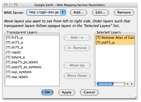
There are plenty of WMS servers preloaded for you to try right out of the box:

wmsimage2.jpg

I chose a server with content for Canada, chose a few layers, and I got this:

wmsge.jpg

In this particular case, every time I pause, the WMS server will be queried anew for an area approximately the size of the screen. Seamless.

[Update 10:19 UTC: Forgot to mention the coolest part: Once you have WMS-based image overlay, you can of course just right-click on it in the Places sidebar and save it or send it along to others. They in turn don’t have to know anything about WMS to be able to enjoy the same functionality you’ve just created.]

New Google Earth beta out: Supports WMS, time tags, UTM grid

A new Google Earth beta is now available for download. Most interesting new features (free version):

  • Native WMS support (!)
  • Support for timelines with the <TimeStamp> and <TimeSpan> KML tags, which now work
  • New API controls for the network link: Language and client version
  • UTM grid support
  • The PC version gets support for joysticks and 3DConnexion Space devices

There are plenty more features listed in the release notes, below the fold.

Continue reading New Google Earth beta out: Supports WMS, time tags, UTM grid

Adobe Photoshop Elements 5.0 tries its hand at photo georeferencing

Just announced, Adobe Photoshop Elements 5.0 for PC ($90). A new feature: Georeference your photos. The blurb explains:

Relive memories by viewing and sharing your photos displayed on an interactive map in the exact locations where they were taken (works with United States addresses only).

6_map.jpg

An address-based georeferencing tool? Why? And why just US addresses? Sorry, but that’s not good enough. PSE5 should also map EXIF-based coordinate data, let you georeference globally by navigating to a spot visually, and allow you to export photos as EXIF or KML (much as Picasa 2.5 beta does). Maybe PSE5 does all these things, but if so they’re not telling.

The big picture here is that Picasa has a natural advantage when it comes to georeferencing because it can call on Google’s superior geospatial dataset. I think Adobe (and Apple with iPhoto) would do better to focus on a plugin system that lets us users choose (or build) their own georeferencing tool (and also photo sharing service). Use Flickr? Picasa Web albums? Panoramio? Why not edit photos in PSE5 but share them with a tool of choice? If Adobe is serious about entering the photo georeferencing and sharing game, they need to realize that there are better free solutions out there right now than what they’re advertising for $90.

New content for Google Earth: UNEP, US national parks, Discovery Channel

Available in Google Earth now, and just announced in a Google press release, (whatever happened to Google’s press-release-by-blog-post practice?:-): New stuff in the “Featured content” folder in the Layers sidebar. Some of it’s been there for a while, but brand new is a layer by the United Nations Environmental Program (UNEP), a layer by the US National Park service, and expanded global content by the Discovery Channel.

The UNEP content is vast, and wonderful. For the Three Gorges Dam, for example, you can click on links to detailed overlays showing how the dam is filling up. (Be patient with the downloads, though.) This is quality stuff. (ZDNet also has a writeup.)

[Update 14:48 UTC: As Google Earth Blog notes, the other vector layers get a reorganization. And there’s 3D buildings in Japan.]

Media Watch: Chinese base investigated; SciFoo trends

Two noteworthy articles well worth a read, and not just because Ogle Earth is mentioned:-)

  • In the San Jose Mercury News, China correspondent Tim Johnson writes up the new phenomenon of social spying — Exhibit A is the discovery of accurate miniaturized terrain on a remote Chinese base by a Google Earth user. Why is this article so great? They actually sent somebody all the way out there to investigate the base. It leads to some great quotes, though the mystery remains unsolved for now. (I’m not quite Swedish, though:-)
  • Over on Forbes.com, Elizabeth Corcoran writes a Letter From Silicon Valley about last month’s O’Reilly’s Science Foo Camp. (Was that only a month ago? Time flies.) Many of the presentations that impressed her have a clear geospatial/sensor web component to them — in this she echoes Nature’s special issue about sensor webs back in February.

Catching up: Mindmaps to KML; Dutch censorship redux…

Well, I’ve found an apartment, solved internet connectivity issues with an unmetered 3G mobile internet account (Sweden is good that way), and now it’s time for the catch-up:

  • Ed Parsons was at AGI2006 and he confirms news of the impending timeline for Google Earth (before ZDNet even, sorry).
  • We’ve already seen how you can use EditGrid, the online spreadsheet, to produce XML and then KML. Now KaMeLwriter (get it?) lets you turn mind maps and spreadsheets into KML. It’s free, but alpha, and not exactly idiot-proof. Here is the post on Google Earth Community.
  • Meanwhile, EditGrid adds charts, and of course gives them a permalink. How many hours before Valery Hronusov does something cool with charts in KML? Hmmm…. How about using the coordinates for a scatter chart and then turning that into a dynamic overlay with assorted added analytics?
  • Bionic Teacher has a cool idea for using Google Earth in the classroom: Mapping out a scale model of the solar system over the local neighbourhood.
  • Pages Jaunes, the private company that did a better version of GĂ©oPortail than the official version, is now also first to market with the in-browser Adobe Shockwave-based 3D prototype for Paris and Rennes. One caveat for Intel Macs — getting the plugin to run is a hassle. Here’s how.
  • Matt Giger, he of EarthBrowser, has another go at KML, and feels that it needs some kind of AJAX upgrade. What, straight to GeoWeb 2.0 in just a few years? KML is where HTML was in 1996 — these things take time. But lest Matt’s motives be questioned, he does write “I must say again that I think that Google Earth is the best earth explorer out there right now.”
  • Apple iPhoto’s built-in georeferencing not being developed fast enough to your liking? Why not run Google Picasa with Codeweavers CrossOver Mac Beta? It uses Wine to run Windows apps on Intel Macs, and the beta is free (but temporary). Documenting Picasa asks an interesting question — might this be a way for Google to make the rest of Google Pack available on Mac OS X and Linux?
  • DestinSharks.com has two great KML resources for boaters — US tide predictions, and the NOAA AWOIS database of wrecks and obstructions in the US.
  • Geenstijl has been documenting further instances of censorship in the Netherlands’ new dataset — and they’re up to 191 comments and counting. A turn of phrase in the blog post suggests Google is doing the blurring, though it’s likely the author knows it is the Dutch state that insists on having the images censored before the aerial imaging company can release them.

    Unfortunately, a Poynter.org blogger rereporting the news reads that literally, assumes Google does indeed blur, and then writes precisely that. Yawn.

  • Nemetschek’s VectorWorks for the Mac already can import SketchUp files. Now, the latest version also has “support for Google Earth KML files.” Not clear if that is for importing, exporting, or both.
  • Digitally Distributed Environmentshow-to for creating panoramas from views within Google Earth has been getting a lot of play, most recently on MetaFilter… and it is indeed a clever and original hack. But why make static panoramas when you can fly around in Google Earth, the real thing? Just one reason: the panoramas let you easily alter your viewing pitch.
  • A few final press releases: 3D authoring tool maker QuadriSpace Supports Google SketchUp Files. RealViz’s VTour, ImageModeler to Create 3D Scenes for Google Earth.

AGI2006 tidbits: GE data details; MSFT Virtual Earth upgrade

Two more things of interest in this ZDNet article about AGI2006:

  • Last weekend’s dataset update included 15-centimeter resolution for the first time in areas like the Netherlands and Japan, ZDNet reports.
  • Microsoft Virtual Earth is getting updates — there’s people search, new bird’s eye views in the US, and drawing tools. The most illuminating information actually comes from this post on the developers’ blog. The big picture: Microsoft continues to develop mapping features in-house that Google can rely on a community of developers for. These divergent strategies continue to be clearly defined.

Oh, and I’ve just had it confirmed that there will be an updated version of Google Earth, though not necessarily in the next few hours — in other words, I won’t be staying up for it:-)