Two weeks ago, Google added the ability to subscribe to GeoRSS in Google Maps. A few days ago, Microsoft updated its Live Local mapping tool, adding the ability to publish your placemark collection as GeoRSS. Other improvements included enhanced drawing tools, but also a wholly underwhelming ability to see Virtual Earth 3D in Windows versions of Firefox (once again missing the entire point of using a web browser for delivering content).
And now, this morning, Google has updated its Maps product yet again, adding “My Maps”, user-generated collections of annotated placemarks, lines, and polygons. This is something of a catch-up maneuver for Google, or, more kindly, a change of tack: Until now, Google was happy to let third party developers use the Google Maps API to produce such services. Now it seems that Live Local/Live Search/Virtual Earth’s collections feature (available since May 2006) has goaded Google into offering a similar default functionality.

This sets the stage for a comparison, of course. I tried out both services this morning while in a bad mood — the best mood for reviews.
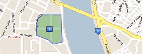
I decided to put some objects here in Cairo on the map. Using Google Maps to do this is very simple. Choose “Create new map” and several new icons appear on the map — for creating a placemark, a line and a polygon.
Zooming in on Cairo in Hybrid mode, we had a problem: Use the roadmap of Cairo, or the satellite imagery? Which one will be accurate in Google Earth? They’re misaligned by about 100 meters, so I decided to put a placemark in both possible spots, and then drew a line between them. Alas, the line didn’t tell me how long it was, so I couldn’t accurately measure the offset.

None of this detracts from the fact that these new drawing tools are very easy to use. Editing is a cinch: Just drag a placemark to a new spot — you’ll find yourself doing it over and over again just to marvel at the lovely animations. Individual polygon points are also draggable, with plenty of visual feedback while you do so.
How does Microsoft Live Local stack up against this? Drawing the same content in hybrid mode for Cairo was a nonstarter — there is no high resolution imagery of Cairo, so no opportunity to misalign it. Using just the roadmap, then, I found the tools to be practically on par with Google Maps in terms of functionality.
Some differences: In Google Maps, editing existing content is more intuitive — just drag a placemark, or right-click on an object for editing options. In Live Local you first need to find the item on your scratch pad. Unlike Google Maps, Live Local does measure distance and area automatically for lines and polygons — but in acres and yards, which is great if you’re Shakespeare. I looked everywhere for the option to use metric units, to no avail. Finally, when it comes to editing the contents of the popup window, Google Maps has more options — you can choose between plain text, rich text and full HTML, which includes the ability to embed YouTube videos and such.
Surprisingly, perhaps, neither service offers the ability to embed your map on your site or in a blog post, especially as the API makes it possible. Tagzania lets you embed your placemark maps — and, by the way, has published placemarks as GeoRSS for ages. Here’s proof, using Google Maps’ ability to read GeoRSS.
Live Local and Google Maps (and Tagzania) give you a permalink to your map. While Live Local will let you see your content in the browser using Virtual Earth 3D (but only on PCs), Google Maps (and Tagzania) offer a link to the map in Google Earth. How does that measure up? There are still some conversion problems for Google: In Google Maps, X marks the spot where the icon hits the ground. In Google Earth, X is at the middle of the icon. The result is that placemark icons are off-center in Google Earth, like so:
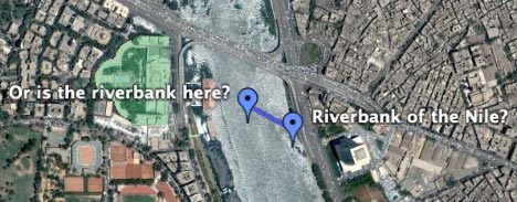
(In case you’re wondering, the satellite imagery in Google Maps aligns with the imagery in Google Earth. Google Earth doesn’t yet have road data for Cairo.)
So, the verdict: I will continue to use Tagzania for annotating places, especially as it uses tags to organize your “collections” and publishes them as both GeoRSS and KML. But tags are still something for the Web 2.0 crowd, not my parents, and Tagzania doesn’t do polygons and lines or embedded videos, so for this sort of project I’d recommend Google Maps over Live Local — mainly because the editing of existing content is more intuitive, and because you can stuff more stuff more easily into the popups.
(One more thing: Also added today in Google Maps: The search tool returns georeferenced content found in indexed KML files, just as has been possible in Google Earth for a month or so now.)