- Earthware Blog discovers a very nice Google Earth comparative mapping utility: Turn on this network link, and you get crosshairs in the center of your screen with links to that location in Google Maps, Windows Live Local (and Yahoo! Local, though this latter link is broken, currently.) While you’re at it, check out Earthware Blog’s first georeferencing project: UK Cinema Film Times in Google Earth, updated daily.
- Geography 2.0‘s Alan Glennon concocts a proof of concept whereby you email placemarks to a content management system and then have them appear automatically in Google Earth via a network link. To do this, Alan assembled basic off-the-shelf web technologies — a service that allow you to post to blogs by email, Blogger, and a regularly executed PHP script that constructs a KML file. Here is the blog, here is the KML file, and here is Alan’s page explaining the project.
Almost simultaneously, disaster relief project Strong Angel III has been experimenting with converting SMS messages into collaborative georeferenced news, especially in the context of a major disaster. Here too, users are asked to identify where they are before sending news; with mobile phones, however, technologies are in place that will soon make that step unnecessary — triangulating mobile phone signals from different towers could be used for positioning. It’s not implausible that you will soon be able to SMS emergency news to a number, say, 911, and have this pop up on a universally accessible map. The main challenge, as I see it: pranksters playing with pay-as-you phones.
- InformationWeek begins its (very interesting) article on Google thus:
In Building 43 at Google’s Mountain View, Calif., headquarters is a video screen that depicts the world as seen in Google Earth. Across a revolving globe, streams of colorful pixels, like sparks from a Roman candle, mark the geographic origin of queries coming in to Google’s search engine. It’s a real-time representation of Google as the nexus of human curiosity.
Boy would I love to see that on my desktop.
- A module for Drupal that adds KML georeferencing to posts is as good as ready over here.
- GIS authoring application Manifold is no longer encouraging users to appropriate Google Maps tiles via its software, citing Google’s intention of enforcing its licensing constraints. (Via The Earth is Square)
All posts by Stefan Geens
NASA World Wind comes of age
Congratulations NASA World Wind development team — you have just logged your very first official complaint regarding your app’s country borders:
APA’s Europe bureau reports the regional map presented by NASA, which has created analogue of Google Earth program on www.worldwind.arc.nasa.gov, shows Azerbaijan’s Nakhchivan Autonomous Republic as territory of Armenia. This mistake was not in the Google Earth program. Taking into account that NASA is a state agency, this is a quite a serious mistake.
This must amount to something like coming of age for a mapping application — having one’s data offend far-away nationalists with chips on their shoulders.
Burning Man 2 Google Earth
Burning Man — running from August 28 to September 4, is located a few kilometers north of last year’s edition, in northwest Nevada. This year, a subsite is dedicated to bringing Burning Man to Google Earth — Burning Man Earth.
Currently, the main network link either doesn’t work or isn’t running yet, but already there is some fine content there, such as georeferenced events and SketchUp models. Boing Boing has also been posting a map and GPX data. What I haven’t found to date is a comprehensive map overlay with event data as a network link, so I made one.
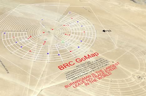
I converted the GPX data to KML. I then took this PDF map and coverted its components to transparent overlays, aligned with the GPX data. I then took Burning Man Earth’s events file and wrapped a network link around it. You can download the whole thing here. Wish I was there.
If you want an even wider perspective, check out this post on Google Earth Community.
Traveling Salesman Problem Solver for KML placemarks
The Traveling Salesman Problem (TSP) is a classic computer science challenge: What path do you choose when visiting a set of destinations so as to minimize the distance traveled? It’s a problem for which there aren’t any easy shortcuts or a quick formula, and hence it’s become something of a cause célèbre among mathematicians and programmers for measuring the efficiency of algorithms and the processing speed of grid computers.
One of the most impressive recent TSP calculations minimized the distance traveled between Swedish towns — all 24,978 of them(!). I was hoping to overlay the map of the shortest route onto Google Earth, but the projection isn’t right. The raw data is available, so I might well turn it into a KML file sometime.
In the meantime, though, I wanted to make my own TSP solver for KML files of placemarks.
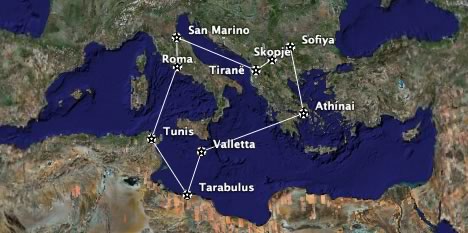
Instructions: Collect up to nine placemarks in a folder. (Hint, you can also right-click on city icons and save them as placemarks.) Right-click on the folder and Save it locally as a KML file (NOT as a KMZ file). Use the TSP Solver to upload the file and wait around 10 seconds. You’ll get a KML file back that contains the shortest route between those placemarks. Guaranteed:-)
Unfortunately, This being a PHP script running on a server, nine placemarks is all that the algorithm can manage in a reasonable time. Ten placemarks would take 10 times longer. The current algorithm isn’t very efficient, in any case, and I’ll be playing with better solutions in the coming weeks, but I just wanted to get a base system working now. Any speed suggestions are most welcome, or else feel free to roll your own, better TSP solver.
Short news: Agent Earth, Georeferenced Frick, Rockit
- This morning, Agent Earth (beta) worked fine: Throw a US zip code or address at it and out comes KML file containing all the real estate for rent or for sale on Google Base. In other words, it’s a Google Base – Google Earth mashup, wrapped in a nice package. Tonight, though, I couldn’t get it to work. Try your luck.
- The Frick Collection ranks among my absolute favorite museums. Now a significant portion of its art has been georeferenced down to the specific room by LuciaM on Google Earth Community, with an image and further links for each painting. Love it…
- Rockit is an Italian music site that has georeferenced scores of music places in Italy. Some of them that I know definitely match up. I only wish the venues would be updated with live info, but failing of that, many of the placemarks have links to websites where you can get such details.
Morocco censorship? Possibly not.
An update on the reported blocking on Google Earth’s servers in Morocco. Two further news items have surfaced that appear to confirm multiple user reports of Google Earth’s servers being inaccessible from as long ago as August 14.
That, at least, is what Maroc IT reports, in an article pretty much parrotted by France’s PC Inpact. The only problem is that both articles manage to get pretty much every other fact wrong. No, India, Israel and South Korea have not blocked access to Google Earth, only Bahrain. No, the US government has not “insisted” that Google Earth censor the White House and, where-do-they-get-this-from, large parts of Manhattan.
Best to head for the hard-core local bloggers then. Temps Libres has a blow-by-blow account of attempts to connect, and manages to localize the problem. As of yesterday, at least one provider — Maroc Télécom — has unblocked Google Earth’s servers. Temps Libres puts it succinctly:
La question qui se pose maintenant est, était ce vraiment de la censure ou bien un simple probléme technique ?, peut être qu’on ne saura jamais!
(“The question now is, was it really censorship or a simple technical problem? Perhaps we’ll never know!”)
What I really love about the censorship debates around Google Earth is that — unlike other content deemed subversive online — Google Earth can only ever be faulted for portraying reality accurately. There are no incitements to violence, nor tendentious arguments, no blasphemies, no racist or bigoted polemics, no slander, no hate speech… Just images. Governments wanting to repress access to the information in Google Earth’s databases cannot credibly justify doing so with the usual pretext of protecting the populace from moral turpitude — which didn’t stop Bahrain from trying, BTW.
Instead, arguments in favor of governmental hobbling of Google Earth have to raise the specter of public security — except that many other commonplace tools are far more dangerous, starting with cars, cell phones, GPS units, paper maps, digital cameras, laptops, the Internet itself, wire transfers… Worst of all, government bans on Google Earth merely blind the locals — everyone else is still all-seeing.
UMPC + GPS.RADAR = Google Earth on the go
When Windows Origami was but a twinkle in the rumormonger’s eye, we here at Ogle Earth (and by we, we mean I) speculated on its possible use as a portable Google Earth with live positioning via GPS. Not six months later, enter JGUI’s GPS.RADAR, available now for download as a freeware beta.
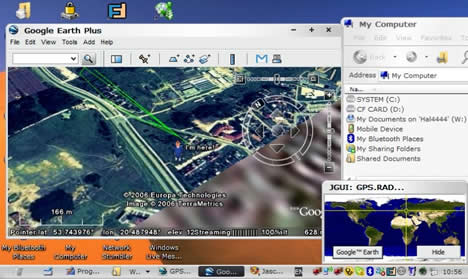
Of course, none of us (and by us, we mean I) actually have an ultra-mobile PC (UMPC), but it’s programs like GPS.RADAR that begin to make Origamis interesting. (Via ZDNet’s The Mobile Gadgeteer)