- Hot on the heels of a KML module for the Drupal content management system, Dan Karran has now released a GeoRSS module. End result: You can suck in GeoRSS feeds into Drupal and show them as KML. (Via GeoRSS blog)
- Now that time is supported in Google Earth, Adam Burt has added time stamp data to the Blojsom CMS template he uses to output his blog as KML. Here’s a screencast of how it works. (Via Bedeviled Mojo Slop)
- Brian Flood demonstrates how the timeline works with overlays of Hurricane Katrina, and promises much tighter integration with ArcGIS coming up. Gorgeous.
- Valery Hronusov updates his existing bird migration data to take advantage of the timeline, putting the whole thing into EditGrid in the process.
- Digitally Distributed Environments is exploring ways to use SketchUp to rapidly apply photographic textures to sides of buildings.
- Google is helping Saturn to advertise their cars via the web in several US test markets, and apparently it involves Google Earth, reports the New York Times. It’s not clear how, but to me it sounds like they’re merely showing Google Earth footage inside a Flash banner ad. And that’s not anything to get excited about. (
All posts by Stefan Geens
DIY high-altitude ballooning
 Genius! Not a mile from where I worked this summer, Cambridge University students earlier this month launched Nova 1, a meteorogical balloon juryrigged with a digital camera, GPS, mobile phone and radio transmitter. The thing went 32 km straight up and took 857 photos at 15-second intervals, some of which show some clear curves. it returned to Earth via parachute, landing 45 km due East a little under three hours later.
They’ve turned the positioning data into KML, though their link is a bit iffy. Here is a proper network link for it. The result looks like this:
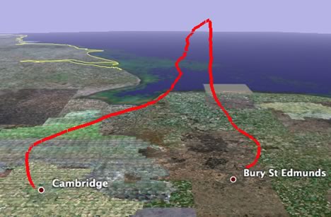
What I’d really love to see is a time-enabled path with screen overlays for all 857 photos. It’d be trivial to do. I can’t wait for Nova 2.
Belgium vs Google: The verdict
The following is not really Google Earth related, but it does have that Belgian angle…
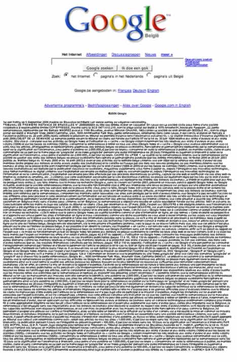
Google has now posted the Belgian court’s judgement in full (Google’s English translation — ooh the irony) on google.be, as instructed. The effect is comical:
I went to the trouble of reading it (it’s okay, I also went on a long walk through late summer Swedish forests for balance) and just want to highlight the crux of the judgement, which happens to be unintentionally funny:
Investigations showed that when an article is available on the site of the Belgian newspaper, Google sends you there directly, using deep links, but that, as soon as this article is no longer present on the paper’s site, it is possible to obtain the contents via a link to a version that Google has recorded in its “cache”, which is in the gigantic database that Google maintains in its enormous server farm [yes, singular].
(“Attendu que ces recherches l’ont notamment conduit à mettre en évidence que, lorsqu’un article est toujours en ligne sur le site de l’éditeur belge, Google renvoie directement, via le mécanisme d’hyperliens profonds, vers la page ou se trouve l’article mais que, dès que cet article n’est plus présent sur le site de l’éditeur de presse belge, il est possible d’en obtenir le contenu via l’hyperlien « en cache » qui renvoie vers le contenu de l’article que Google a enregistré dans la mémoire « cache » qui se trouve dans la gigantesque base de données que Google maintient dans son énorme parc de serveurs;”)
I love the last bit; makes you wonder if the the judgment had been different if the server farms were smaller or the database merely “large”. (And the judgement also twice prints Google’s address as “1600 Amfitheater Park Way” — don’t these lawyers know English? :-)
As for the merits of the above argument, it seems to turn on the fact that Belgian francophone newspapers want to make money off their archives, and that Google is seen to prevent them from doing this by offering a free cached version. Google’s defence was that anyone can request that they not be cached (I’m guessing via a server’s robots.txt file) but the Belgian francophone papers are arguing that the default stance should be no caching, and that Google should ask for permission before it shows cached content. In other words, it’s about who should be going through the trouble of asking.
Of course, Google without its cache would be much less of an institution, so I understand why they are fighting this; should the idea of requiring permission for serving cached copyrighted material gain currency, it could spell trouble for Google, though not just for them — the wholesale caching of content (copyrighted and not, by a great many companies, including European ones) is a cornerstone of the web as we know it. The Belgian ruling states that Google serving cached content copyrighted by the plaintiffs without prior permission is illegal. The danger is that in its zeal to teach Google a lesson, the court may have now also put a chink in that which makes the world wide web such a compelling technology.
Belgium vs. Google Earth redux
So we already know Belgium’s military is pissed at Google Earth for the ease with which it makes detailed aerial imagery of Belgium available. (Here is the original article by the Belga news agency that was the source of the television news broadcast blogged yesterday.) The question is, what can they do about it?
According to Belgeoblog, they’re getting support from at least some politicians and business interests. One Belgian senator on the intelligence oversight committee has promised a report on the matter by the end of September, and she wants to draw up a list of sensitive sites, much as the Netherlands has. One security industry representative says that companies which own nuclear power plants are especially unhappy about the images:
They do everything to keep such sensitive information secret and suddenly it’s made public, without an opportunity for them to defend themselves.
That quote either betrays massive ignorance or willful subterfuge — such imagery has long been public, and if they’ve been operating their plants under the mistaken assumption that nobody ever flies overhead, then perhaps there should be an oversight committee report on that.
But, again, what could Belgian legislators do? One possible scenario (if this doesn’t fizzle out) is a new censorship law that will compel aerial imaging companies operating in Belgium to submit freshly gathered data for censorship against a list of sensitive sites (again, like in the Netherlands). If so, let’s hope Google purchases imagery of Belgium before such a law come into effect — and we’d have a textbook case of legislators closing the barn door after the horse has bolted. Another option: Google could in the future choose to purchase satellite imagery instead — no country has jurisdiction in space.
But considering the cavalier attitude of Belgian courts regarding what you can and cannot do on the Belgian internet when linking to news if you’re Google, it’s not entirely inconceivable that they might try to get Google to censor imagery that is already being served via Google Earth, retroactively as it were, threatening various legal repercussions if Google does not comply. Although no country has taken such a step, not India, not China, not Russia, how ironic would it be if Belgium were to try?
Short news: Of APIs, plugins and exporters
- Google Maps’ API has changed slightly. If you want to link to the KML version of a Google Map location, you now need to add an “@” before the latitude, like this:
http://maps.google.com/maps?q=@48.89,2.36&output=kml
- Avi Bar-Ze’ev begins a mammoth 9-part exploration of the coming 3D web, (or Web 3D, as he calls it, not to be confused with 3pointD:-). In part one today, some history: Why the precursor to Google Earth wasn’t a browser plugin.
- SketchUp models can now be “published to the web” with the Hypercosm Teleporter for SketchUp Pro, as per this press release. The idea is that you can then view SketchUp models in 3D from within the browser, using a browser plugin, the Hypercosm Player. Problem is, the plugin is only available in Windows, which rather defeats the entire purpose of building a browser plugin, no?
- Google Earth developers are among the winners of this year’s San Jose’s Tech Museum of Innovation awards for their work as part of the Global Connection Project Team, “developing software tools for use with Google Earth to help disaster responders get accurate and timely information during recovery efforts.” Nobody tell the World Wind guys. (Via SFGate)
- For Mac users, Brian Thoth’s Google Maps Plugin for the Address Book is now at version 2.6, featuring improved Google Earth support.
- Looking for naked people in Google Earth is by now an established sport, but this is new: Possibly finding one in the Netherlands, and then having Dutch TV racing to the scene to try to identify the person. (No luck, though).
- Log2GoogleEarth visualizes live traffic to a website in Google Earth. I haven’t tested this myself but the screenshot looks interesting.
- Gorgeous: Digitally Distributed Environments shows us how to make pixel art in SketchUp.
- IMVU, a 3D chat application for PCs, can now import SketchUp content. Good question: Where is the SketchUp model importer for Second life? (Via 3pointD)
Bahrain in Google Earth, unplugged
Want an example of how the internet regards censorship as an obstacle that needs to be routed around? Take this PDF (4MB), 45 pages of annotated Google Earth screenshots of Bahrain, apparently being emailed around the Persian Gulf. While it would be nice for us with access to Google Earth to have this content labelled in the Google Earth Community layer, the whole point about the PDF is that you don’t need access to Google Earth’s servers to see the pictures in the PDF.
The main thrust of the PDF is that:
Illegal distribution of property is estimated be 200 square kilometers since independence (out of 665 square kilometers total land area) = 30% of Bahrain’s total areas total area = USD 60 Billion!
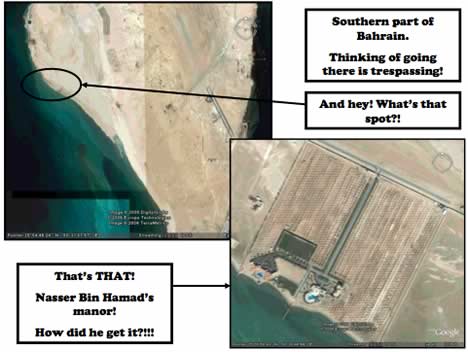
Pamphleteering doesn’t get much more visceral than this (even if I have no easy way of verifying if it is true). If Bahrain’s government wants to prevent the spread of this kind of information, it will have to ban email. (Via The Skeptic)
(Previously: Bahrain bans Google Earth, Bahrain Censorship redux)
Belgium vs. Google: Google Earth’s turn
What is up with Belgium?
First, Belgian francophone newspapers throw a legal hissy fit about Google’s links to their articles being accompanied by snippets of context so that users might actually want to click on them. It’s obviously fair use on the part of Google, but a luddite Belgian court found otherwise, and now Google has complied by removing Le Soir et al. entirely from Google.be. Le Soir must really hate the hassle of serving all that traffic that Google sends them, and then there’s all those bloggers that find their stories via Google and insouciantly post excerpts with links to them! The gall of some people!
Second, and far more relevant to this blog, on Tuesday a Flemish TV channel’s evening news reported that the Belgian military now wants high resolution images of their bases removed or obscured on Google Earth and Maps, according to the always reliable Belgeoblog (in Dutch). Apparently, “the strategically important images should not be available to everyone.” Presumably, they should just be available to people who really really want them for some reason and will thus buy them directly off the vendor.
As recently as May this year, the Belgian military said the exact opposite, and this was proudly reported on Ogle Earth (I’m Belgian, see?). Then, the military said it was “not afraid” of such imagery being useful to terrorists, that such imagery was already public anyway, and that without context it was meaningless. All of those arguments are as true now as they were in May — for example, here is some publicly available high resolution imagery of nuclear weapons bunkers in Belgium that is not served by Google, as an overlay on Google Earth, again courtesy of Belgeoblog.
So what changed between now and then? Well, Belgeoblog thinks that this institutional schizophrenia points to disagreement within the military establishment on how to deal with the ongoing democratization of geospatial data. But something else changed since May: Belgium got a partial upgrade to its imagery in Google Earth, so that now a non-trivial chunk of the country is at the same high resolution as the Netherlands. Indeed, much of Belgium’s new (aerial) imagery is taken by the same company that scanned the Netherlands in its entirety — AeroData. (AeroData happens to be Belgian, operating out of Antwerp’s Deurne airport.)
My guess, then, is that some general nearing retirement discovered Google Earth last week, zoomed in on his barracks, saw the new imagery, and got yanked into the 21st century a tad too forcefully.
The Dutch government’s censorship of AeroData’s imagery has been well documented on Ogle Earth. It’s deplorable, but the Dutch have laws dated from the cold war that allow them to censor the imaging taken by planes in its airspace before the vendor is allowed to take it into the public domain. Belgeoblog says that Belgium has no such laws on its books, and that therefore all the military can do is whine. I hope that’s true (though it’s hard to verify), but I’m also not putting it beyond the abilities of Belgian courts to come up with some completely spurious argument as to why if Google is doing this, it should be banned. If there is no fair use in Belgium, what else is fair game?