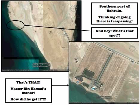
Want an example of how the internet regards censorship as an obstacle that needs to be routed around? Take this PDF (4MB), 45 pages of annotated Google Earth screenshots of Bahrain, apparently being emailed around the Persian Gulf. While it would be nice for us with access to Google Earth to have this content labelled in the Google Earth Community layer, the whole point about the PDF is that you don’t need access to Google Earth’s servers to see the pictures in the PDF.
The main thrust of the PDF is that:
Illegal distribution of property is estimated be 200 square kilometers since independence (out of 665 square kilometers total land area) = 30% of Bahrain’s total areas total area = USD 60 Billion!
Pamphleteering doesn’t get much more visceral than this (even if I have no easy way of verifying if it is true). If Bahrain’s government wants to prevent the spread of this kind of information, it will have to ban email. (Via The Skeptic)
(Previously: Bahrain bans Google Earth, Bahrain Censorship redux)
They will have to ban Flickr, as well. See this pool.