All posts by Stefan Geens

Google Earth, Indian accountability tool?

Details are hard to come by reliably, but it would seem that the Andhra Pradesh state government is being rocked by a scandal concerning the acquisition of land for the building of a ring road around Hyderabad. A crucial piece of evidence in this affair was apparently gathered by firing up Google Earth and pointing out that imagery from 2004 showed no construction on land that a government official maintained did have construction on it then — presumably a retroactive fib to explain why the ring road had been routed around it.

Popular Indian IT blog Digital Inspiration flags the story and credits Google Earth, but the crucial source it links to is down, while an article referred to in the Hindu does mention the scandal but not Google Earth.

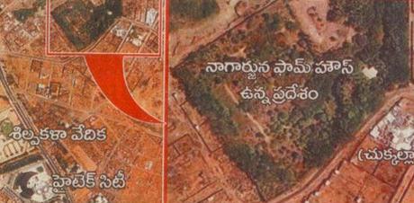
What to do? These stories coming out of India where Google Earth Saves are beginning to have the sheen of urban legends, but at the same time Hyderabad’s imagery is from 2004, and the color tone matches. I spent some time trying to locate the following image, but without luck. Perhaps Hyderabad locals could point me in the direction of the Puppalaguda suburb:

google-earth-hyderabad.jpg

If the story is true, what delicious irony! Who’d have bought DigitalGlobe imagery from 2004 to verify a minister’s explanation? Not me. Who’d have started up Google Earth to verify a minister’s explanation? Definitely me. The democratization of access to geospatial data continues apace, to good effect, especially in India.

[Update 22:20 UTC: This story makes James Fee’s question especially pertinent: Had Google updated its imagery of Hyderabad sooner, the minister would have been scot free. A timeline for the baselayer would indeed rock — even if it were an affordable premium service.]

Short news: Franson GpsGate, FS Earth, PictureSync

  • Interesting confirmation by All Points Blogof the low-key launch of SkylineGlobe. Remember also how ArcGIS Explorer’s anticipated launch was delayed from the end of July, soon after GĂ©oportail’s disastrous debut? I think lessons were learned from the French debacle — namely, that not being able to meet demand can be a reputation killer. In other words, stage-fright can be a wise sentiment.
  • This came out in August, but hasn’t been blogged here yet: It’s a Google Earth plugin pack for the Franson GpsGate ($10) which lets you use a GPS device with a number of applications simultaneously — this now includes live tracking in Google Earth. It’s made in Stockholm, so it must be good:-)
  • FS Earth, which plots your virtual plane’s position in your flight simulator to Google Earth, is now compatible with Microsoft’s Flight Simulator X (in addition to Flight Simulator 2004). FSX is due out before the end of the year. Until then, there is a trial version. (Via AVSIM Online)
  • PictureSync for Mac (and soon Windows) ($14) lets you annotate and batch-upload your photos to a range of online photo sharing services. In version 1.6 you can geocode photos using Google Earth.

Search Sweden’s historical monuments, get KML

Back in May, David Haskiya of Sweden’s Office of Antiquities (RAA) wrote in to report that they were experimenting with KML versions of their geospatially enabled database of historical monuments. There was one potential stumbling block that needed to be resolved, however: Should this database be made public at all?

The decision has now been made — it’s public as of last Monday, and here is the press release to prove it (in Swedish). What the press release glosses over (but which David wrote in to highlight) is that the database queries are saveable as URLs that dynamically generate KML files.

It’s all in Swedish, so follow along. Here is an HTML search result for Swedish Iron Age Dolmen, which are large distinctive burial stones. Notice the link to a KML version of the results just above it? Place that inside a network link in Google Earth, and it will update along with the database, which David says is growing all the time. (In other words, that KML link would be even more useful if it came shrinkwrapped inside a network link which we could download. How do you say “shrinkwrapped” in Swedish?)

Adds David (translated from Swedish):

Developments we’re planning for next year include integrating an interactive map into the site, setting up RSS and WMS services, and experimenting with KML’s timestamp functionality to create historical patrimony maps with time depth. [Yes!]

(Another of RAA’s databases — this one mainly of georeferenced photos of Swedish churches — now also carries links to KML, in addition to two local Swedish web mapping services. Examples here and here.)

This is going to make a lot of history classes in Swedish schools a lot more interesting.

[UPDATE 2006-10-11 11:45 UTC: David just wrote to say that they’re busy installing extra servers to deal with the unanticipated extreme demand for the service, as many Swedes are now checking to see if they live near interesting archaeological monuments. And he’s also looking into adding a network link.]

Short news: Ornithology revolution; early SkylineGlobe reviews

  • The miniaturization of GPS tracking devices is leading to a revolution in ornithology, reports the Boston Globe, as smaller and smaller birds can be tracked.
  • Yet another story about how Google Earth is empowering the individual, and yet again it’s set in India. This time, farmers used Google Earth to win higher compensation for their land when forced to sell it to the government, apparently because they were able to show it was more fertile than the government had contended. Moneycontrol India has the story.
  • Virtual Globes Directory Blog and The Earth is Square are first out the gate with reviews of Skyline Software System’s SkylineGlobe.
  • James Fee detects an inkling of GIS developers wanting to veer away from ESRI server products in favour of their home-grown server-client solutions. This leads to an interesting question: Is ESRI about to feel the sting of widespread adoption of open-source server solutions? Bear in mind that whereas Linux has not had a big impact on Microsoft’s desktop OS business, Microsoft has never caught up with Apache in the web server market.
  • Google Earth continues to remain in the UK public’s zeitgeist. “Google Earth” was the 18th most popular search term in September, according to Hitwise. It wasn’t the most popular mapping search term, however — that honor went to “Multimap” at #17, whose maps have long been the staple of UK cabbies.
  • Clickable Culture wonders whether Second Life might not be the victim of its own success, given the number of attacks it has suffered of late, and the effect this has had on the overall stability of the system.
  • In case you haven’t read it, Newsweek has a nice color piece about how the growing internet mapping “industry” is fuelling demand for aerial imagery and the companies that provide it.

SkylineSoft’s SkylineGlobe launches, competes with Google Earth

Skyline Software Systems has now publicly launched its virtual globe, SkylineGlobe, using their TerraExplorer viewer. From an email sent around by SkylineSoft’s Ron Ledany:

SkylineGlobe.com is our free public website, featuring [an] interactive portal with high resolution imagery in the US. Within the next few months I will add most of Europe, Japan, Taiwan, and Israel (of course) in high resolution as well.

Although SkylineGlobe looks much like Google Earth, we have stronger streaming technology and fusion capabilities with Oracle and ArcSDE databases, ability to display ‘Live Terrain’ feeds and more…

I am also proud to announce that we already have a dozen integrators that develop applications using our 3D solution…

sklnglb.jpg

TerraExplorer is a 7.4MB download for Windows. Skyline Software Systems, of course, is the company currently in a patentinfringement tiff with Google over 3D rendering technologies.

3D Nature’s 3D trees: Colliding COLLADA standards?

3D Nature has now published an example KMZ file showing off how its exported 3D trees look in Google Earth 4, using COLLADA. These trees are “crossboards”, Xs of two transparent 2D tree images:

trees3dn.jpg

Google Earth 4 does render these COLLADA objects, but not without problems that lead to flicker and wrong choices regarding transparency rendering. 3D Nature says it’s because Google Earth doesn’t properly render COLLADA objects in some cases:

… Current releases of GE4 do not seem to properly z-sort polygons that have transparent textures (like our trees) resulting in some display artifacts on trees. 3D Nature has verified that our transparent COLLADA tree objects do work properly in other COLLADA-supporting applications, so this is a fix that will have to be made by Google.

3D Nature’s Chris Hanson adds in an email:

Basically, GE doesn’t seem to be z-sorting the transparent tree polygons the way realtime transparency requires. Maybe they’re just sorting on a per-object basis and not sorting on a per-polygon basis. Either way, it leads to occasional strangeness. This is why we normally prefer billboard trees — they work fine with per-object sorting — but GE4 doesn’t offer billboarding.

We could entirely do away with the need for z-sorting by using an alpha clip mode (binary transparency — fully transparent or fully opaque, nothing in between) but COLLADA doesn’t seem to offer that option, so there’s no way to communicate it to GE.

In any case, I don’t think trees are Google Earth’s biggest priority, so I don’t know if this issue will ever get much attention. I expect if you made a similar object in SketchUp it too would suffer the same problem.

WorldWind will suffers the same problems, as I don’t think they z-sort anything either, but it appears that the DirectX .x 3d object format they adopted (and we have implemented support for) offers alpha-clip mode.

Kaon Interactive’s Joshua Smith had a similar complaint in an interview by Avi Bar-Ze’ev:

But COLLADA is still very rough around the edges: Google Sketchup is starting to flood the market with not-quite-valid COLLADA files (which could lead to a repeat of the whole “it’s wrong, but it works in IE, so it’s right” HTML debacle).

And that would suck. But Google Earth 4 is still beta, so it’s early days yet when it comes to COLLADA support.