All posts by Stefan Geens

Google Earth, Indian farmhand

DNA India has a good article fleshing out the episode of how Indian farmer activists are using Google Earth to get their money’s worth for lands being acquired by the government for “special economic zones”. While the government says the lands are infertile, the farmers say otherwise, and use Google Earth’s imagery as evidence. There also seem to be plans for a Google Earth Unplugged:

Shivkar has decided to make use of Google Earth for a larger cause. He says that Google Earth pictures showing the condition of canals, rivers and coastline in different villages will be displayed as big banners in respective villages so that people would know what environmental changes would take place in the future.

But the article ends a bit alarmingly:

Shivkar is also planning to make use of Google Earth’s pay service facility which provides the latest picture of the specific area.

Don’t do it, Shivkar! The imagery is the same, regardless of the version.

Super Overlay Tiler: Automate the creation of KML regions

One of the big new features of Google Earth 4 is its support for KML 2.1’s regions — a method for saving bandwidth and CPU cycles by showing tiles of imagery at progressively higher resolutions as you zoom in on Earth, rather than having you try to download and render one gigantic file.

The only problem? If you’re authoring a region-based solution, writing the KML and preparing the imagery is not something you’d do manually. And so the lazy and inept among us (I’m thinking chiefly of myself) have been waiting for somebody, anybody, to come out with a software application that automates all this. You know, give it a big file, some coordinates, and out pops the KML and the image tiles. Thanks.

Google has tried to egg on developers by releasing the regionator, “a collection of Python classes and scripts which can be used to generate Region-based KML”. But it’s Paolo Mistrangelo of Magellano Progetti in Milan who now has come out with a free tool for Windows that I’ve gotten to work like a charm — Super Overlay Tiler v0.1.

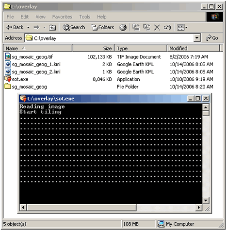
SOT is not exactly a standalone application, but the steps involved are straightforward and do not require programming or command-line prowess. In other words, it may not yet be idiot-proof, but it is certainly me-proof. It took a matter of minutes on my barebones Windows 2000 installation to install RMagick and unpack SOT into the required folder.

I happen to have the British Antarctic Survey’s 100MB TIFF image of the South Georgia Islands lying around — the same one that got incorporated into Google Earth’s dataset in the last update. I put SOT to work on it as per the instructions, and not two minutes later I had me a 33MB folder with 1,451 KML files and 1,280 JPG files in it:

sotw2k.gif

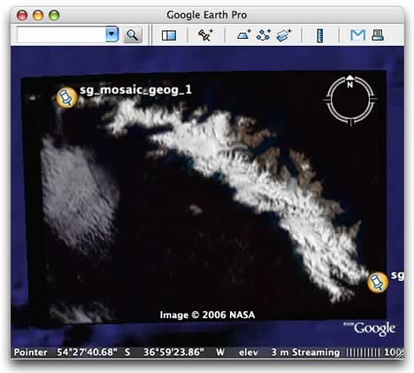
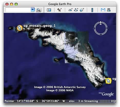
Viewing this in Google Earth from the hard drive resulted in smooth, seamless and instantaneous imagery of South Georgia, icebergs and all. Here are views with and without the region-based KML, for comparison:

regions.jpg

noregions.jpg

I threw the resulting folder onto Ogle Earth’s server, partly as a demo and partly as a stress test. Start here to check it out. (It’s a bit slow, thanks to my server).

The upshot: If you have a massive image file you’d like to publish to Google Earth, Paolo Mistrangelo’s SOT now makes that a straightforward process.

Google Earth Pro extras now free

This just in: Some Google Earth Pro users report getting an email that declares:

Good news! Your Google Earth Pro subscription has been upgraded. Enjoy these new premium features on us (up to a $600 value):

Movie Maker Module – Record 3D viewer imagery and export movies of tours for websites or presentations.

Premium Printing Module – Save and print at 4800 pixels per inch and print high-resolution images up to 11″ x 17″. [Google’s email got it wrong originally, and wrote in to correct this.]

GIS Data Importer – Incorporate GIS data in .shp or .tab file formats. Examples of data include parcel data, demographics data and 3D building data.

You can use these new features the next time you open Google Earth Pro. Also, our Technical Support options have changed. We’ve added live chat & email support to replace telephone support.

A quick check on Google Earth Pro’s web page confirms that these extras, previously $200 a pop, are now listed among the features of Google Earth pro (still $400 a year). On my Mac, The movie making module works like a charm, and for free. One new premium service that’s listed which I don’t remember seeing before (correct me if I’m wrong) is traffic data (sample).

Short news: WWJDev, BBox unbound, Second Life for data visualization

  • WWJDev? The powers that be at NASA are pushing development of the Java version of World Wind, according to the Earth is Square. As a Mac user, I couldn’t be happier. The .Net version’s use of ActiveX controls means it still won’t run in Parallels Desktop for Mac (SkylineGlobe does) and rebooting into Boot Camp is too much of a hassle. In other words, WWJ frees NWW from platform dependence, while also making it a far more viable modular component of other applications.
  • KML guru Barry Hunter describes a method of tweaking the info returned by the bounding box in a network link, so that tilting the view does not result in data being pulled from here to the horizon. He explains it better. (Via his own blog, natch.)
  • This use of Second Life as a means to visualize complex modelling is particularly striking and unexpected to me. Indeed, why not walk around 3D visualizations of data models in Second Life, especially if the datapoints do not need to be constrained by geographic coordinates (in which case Google Earth suffices)? In addition, you get to manipulate the data structure with an object-oriented language using inputs from the web — something not currently possible in Google Earth. I suspect this innovation has the potential to bring Second Life into the boardroom — or rather, to bring the boardroom into Second Life.

Hydarabad land scam: Source found

The missing URL of the blog post by Harish Kumar Bhamidipati that served as a source for the Hydarabad land scam story has now been found, and it comes with a translation of the original newspaper article in Hindi Telugu that started it all. It’s a great read. Google Earth does indeed play a starring role.

hindinewspaper.jpg

Here’s a highly abridged version of what transgressed: As part of a general amnesty, houses built before 2001 on plots of illegally sold land were “regularised”, and thus allowed to be resold on the market. Somebody with government connections got the bright idea of “backdating” some houses built after 2004, pretending that they were there since 2000, so that they could benefit from the amnesty and sell them. Digital Globe imagery from 2004 in Google Earth quickly put paid to that lie.

In a sign the state government is both clueless and in trouble, it maintains that the images were doctored (according to the blogger’s dad). How cunning of Google!

Seriously, though, this argues strongly in favor of keeping archives of successive generations of Google’s base layer. Google Earth Pro lets you access different datasets; why not make older ones available there as a pay service? (Added bonus: placemarks of time-sensitive artifacts like planes in flight could be metatagged to a specific generation of imagery.)

Google for Educators comes with lesson plans for Google Earth

Google today launched Google for Educators, to help teachers use Google products in the classroom. One section is about how Google Earth can be used as a teaching tool, and it includes a page with detailed lesson plans prepared in cooperation with Discovery Education unitedstreaming [sic]. (Strangely, these lessons plans still use the old Google Earth 3 interface for screenshots and instructions.)

Hyderabad land scandal, cont.

Within minutes of posting the Hyderabad land scandal story (and going to bed), several far more adept Google Earth users emailed the location of the site in question:

hyderabad.jpg

It’s still nor clear to me what the parameters of the scandal are, in part because The Hindu‘s reporting is impenetrable, but at least this article by the Deccan Herald from September 30 introduces us to the scandal in plain English:

The entire Opposition, led by the Telugu Desam Party formed a united front as serious allegations emerged of a nexus of government officials and ruling party big-wigs that twisted rules, issued notifications and later withdrew them or allowed them to lapse that enabled them to “grab” vast extent of prime land at low rates from farmers who feared acquisition of their land at throwaway prices by the government [to build the ring road].

… Former chief minister N Chandrababu Naidu pointed a finger at Chief Minister Y S Rajasekhara Reddy and alleged that the government had changed the alignment and notification for the ORR [ring road] project several times to help his relatives, friends and close associates.

One reader who emailed the location helpfully labeled the area “Nagarjuna Farm House”. Googling that (hey, this is a blog, not the NYT) led me to this “gossip” article on greatandhra.com, where an Indian film star named Akkineni Nagarjuna is alleged to have gotten a special tax break from government officials after newly acquiring the property, prompting an outcry by neighbors. (BTW, when I measure the acreage of his “farm house” with Google Earth I get 8.6 acres, not 6.5 acres as reported in the story. Surely it’s not that easy to avoid taxes in Hyderabad?)