Altinum was a prosperous Roman city on the coastal lowlands of northern Italy. It was sacked by Attila the Hun in the 5th century AD, and conquered by the Lombards a century later. Historians now speculate that these events prompted inhabitants from Altinum and other towns in the vicinity to resettle on more easily defended islands in a nearby lagoon… thus founding Venice. (Wikipedia has a good concise history of the town.)
Now the journal Science has published the results of an aerial survey of Altinum by Andrea Ninfo, Alessandro Fontana, Paolo Mozzi, and Francesco Ferrarese at the University of Padua. (You have to pay $15 for the full-text version, but ScienceNOW has an informative (free) article based on the results, while a free PDF supplement contains methodology and original source imagery.) Their research provides us with the first proper map of Altinum.
Why is this out of the ordinary? A few reasons: Altinum was abandoned wholesale, making it is one of the few Roman settlements in Europe not subsequently subsumed by medieval towns. And while Altinum’s building stones were eventually carted off as construction material elsewhere, the foundations remained, and these became especially visible during a drought in 2007. This allowed for an unusually comprehensive reconstruction of the town. From ScienceNOW:
The researchers discovered that the crops planted on the land were in different stages of ripening, thanks to differences in the amount of water in the soil. Lighter crops traced the outlines of buildings — including a basilica, an amphitheater, a forum, and what may have been temples — buried at least 40 centimeters below the surface. To the south of the city center runs a wide strip of riper crops. They were growing above what clearly used to be a canal, an indication that Venice’s Roman forebears were already incorporating waterways into their urban fabric.
The BBC News carries a virtual flyover of the near-infrared aerial image that the researchers took. Italian news agency ANSA has quotes from one of the team members describing what they found:
”We see a walled city, a theatre, an amphitheatre outside the walls, the basilica, the forum with its market, then a principle road connected to the Via Annia (the Roman road through northern Italy),” said [team leader Paolo] Mozzi.
“You can also see a canal that divides the city in two and heads towards the lagoon. Considering the sea level in Roman times, that canal must have been connected to the lagoon as well as with nearby rivers,” he said, adding that the map also suggests a protected port that would have been used by merchant ships.
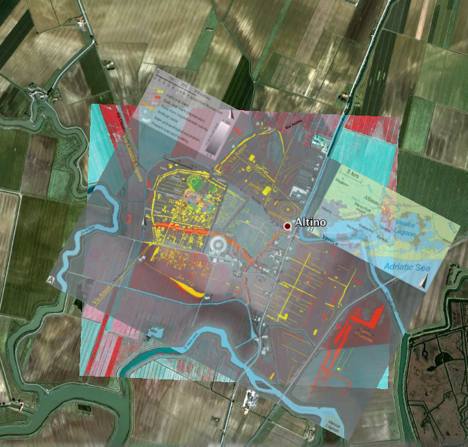
These results are just begging to be put inside the wider context of a geobrowser, so I overlaid both the near-infrared aerial image taken by the researchers and the resultant maps they produced in Google Earth. Here they are, as a downloadable KML file. Be sure to play with the opacity levels of the folder, as well as of the individual layers. It’s amazing how well the amphitheatre and basilica stand out. All source material comes from from the PDF supplement on sciencemag.org.
(My usual tangential rant at this point: When-oh-when will major science- and news publications start publishing geospatial results in geobrowser-friendly formats? In the meantime, we’ll do it ourselves:-)
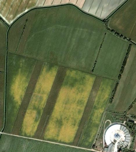
But viewing these overlays in Google Earth is not the only way in which you can enhance the context of this content. This particular area of northern Italy is blessed with an unusually high number of historical satellite images taken over the years and made available in Google Earth via the historical imagery slider (quite possibly because researchers were requesting imagery of Altinum from DigitalGlobe.) Several images from 2006 show many of the features with remarkable precision, and it is also interesting to see how the changing seasons highlight different features. Here’s a quick overview of some of the imagery, as well as the one used by the researchers:
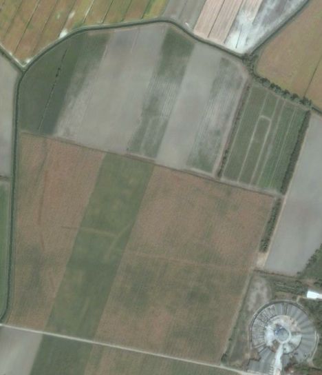
2004/09/11

2006/05/10

2006/07/01
2006/09/13
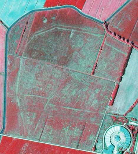
near-infrared image
Notice how some of the images clearly show the semicircular theatre and the odeon structures. (Do compare the base imagery to the overlays.)
There is also “extra credit” material: The Via Annia, built in 131 BC, skirted the northern shore of the Adriatic sea, connecting Roman settlements, including Altinum (map). In the 1st century AD, the first road to allow wheeled traffic across the Alps was built — the Via Claudia Augusta — and one spur of it began in Altinum. Remarkably, both roads are clearly visible on Google Earth for some distance outside Altinum. The Via Annia extends from the southwest of Altinum to the northeast, and is visible as markings in fields for about a kilometer in either direction. The Via Claudia Augusta, on the other hand, shows itself as a long straight line extending northwest, cutting through an otherwise chaotic set of field plots. Clearly, the road came first; it can be followed, without too much imagination, for some 10km out of Altinum, at least until the town of Olmi.
Can you repeat what you have done in google earth with these coordinates?
http://maps.google.es/maps?hl=es&ie=UTF8&ll=36.945639,-6.382499&spn=0.009964,0.022724&t=h&z=16
Doñana’s National Park, in Spain. You can see some “squares”. It’s the suspictious place of the lost city of Tartessos/AnotherAtlantis. A small dig will be done next month there, to confirm (or not) that hypothesis.
Forgive my english. I know you will do that. I did it myself but I would like to see your opinion.
That place was famous in the news in 2004:
http://news.bbc.co.uk/2/hi/science/nature/3766863.stm
Forget about Atlantis as is “too mediatic”, the lost city of Tartessos is believed to have existed over there.