Although Google Picasa for PC has had geotagging tools for a while now, the addition of geotagging to iPhoto ’09 for Mac does imply that the geotagging meme has finally gone mainstream.
But not everyone uses the “lite” tools. What about users of Adobe Lightroom and Apple Aperture? A couple of new and updated tools have surfaced over the past few months:
Lightroom to KML: Bernhard Weichel has produced a cool little hack for Lightroom that takes advantage of the (donationware) LR/Transporter plugin. LR/Transporter is an export plugin for your photos’ metadata, and Bernhard Weichel’s hack is a template that exports coordinate metadata as a KML file. (Via Timothy Armes’s blog, which also points out that you can add coordinate metadata to photos in Lightroom using Jeffrey’s GPS Support plugin — either from a tracklog or Google/Yahoo Maps.)
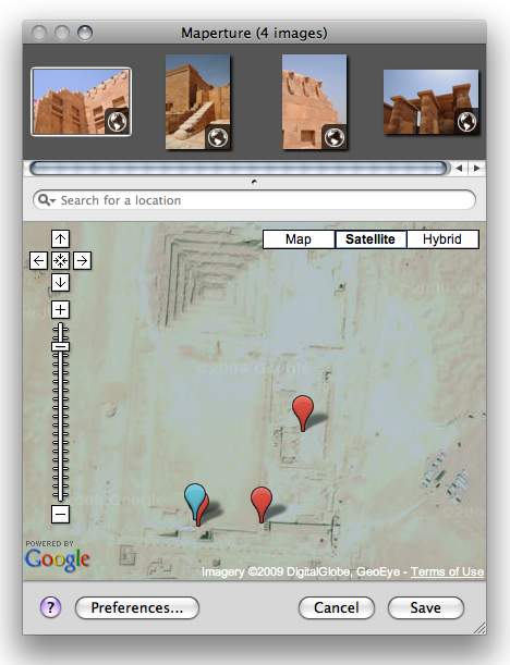
Maperture for Aperture: Übermind’s Maperture (get it?) is a free plugin for Aperture that focuses on letting you pinpoint photo locations on Google Maps. It does just one thing but does it well, and the interface is extremely easy to use. It does not support TIFFs, alas, but it is still actively being developed, with a pro version planned. Screencast here.
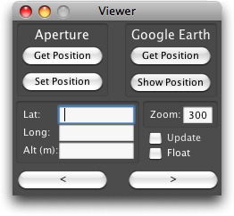
GPS2Aperture: GPS2Aperture has been mentioned on this blog before — an application that lets you geotag photos stored in Aperture via Google Earth; a newer $15 pro version lets you use your tracklogs, and also lets you calibrate times and reverse geocode. Screencast here.
Aperture referenced files: Currently, my way of adding geotags to my photos in Aperture is to keep them as referenced, not managed files — they are not included in Aperture’s database but exist in a separate directory and are referenced by Aperture’s database. I change the coordinate metadata directly for these photos using a free tool like GPS Photolinker or Geotagger. (A well-specced pay alternative is the $30 HoudahGeo 2 for the Mac.) Aperture need not be open when you use these tools, but the changes will be automatically reflected in Aperture when you next use it.
Hey all,
I just wanted to chime in on your discussion about geotagging your images…
We are testing Maperture Pro BETA currently which allows you to visually geotag your images, import tracklog data from a GPS device, reverse geocode location information, save location bookmarks, copy & paste location information as well as several others. If you are interested in testing it out and providing feedback…
Go to http://www.ubermind.com/beta, take it for a spin, and tell us what you think.
Thanks!
Oh, and we also support these formats in our BETA version as well as many new features…
Maperture Pro BETA supports the following file formats:
CR2 / CS1 / DNG / GIF / HDP / JP2 / JPX / JPEG / JPG / MEF / MIE
MOS / MRW / NEF / ORF / PEF / PNG / PSD / RAF / RAW / TIF / TIFF
http://www.ubermind.com/beta/mapertureprobeta-faq.php
I’ve been using HoudahGeo with aperture and it works like a charm for me.