Just passing this along from my inbox. Michael Kosowsky from HeyWhatsThat answers the GIS question of the current political season:
In this post the Inverse Square blog seeks to answer the burning question “from where in Alaska can you see Russia?” (The blog is written by a good friend, and this post is an example of one of its main themes: we should try applying analytic methods to make sense of what’s going on around us. Particularly in politics.)
Horizons and visibility being our expertise, I had to take a crack at it. The result is HeyWhatsThat — Russia?
TECHNICAL DETAILS
Putting the Alaska-Russia visbility analysis together required two things. First, data. I’ve been relying solely on SRTM elevation data, which runs from latitude 54S to 60N and doesn’t quite get us as far north as Anchorage. So I grabbed all I could of Alaska from the USGS National Elevation Dataset via the Seamless Data Server. And please note that I haven’t yet fully integrated that data, so while you can accurately run the mountain peak/visibility computations for Alaska, the contours and profiles for that state will still be based on much lower (SRTM 30″ derived from GTOPO30) resolution data for the time being.Second, to actually try every high point in Alaska to see if Russia is visible would take a long time at two minutes per computation. So I’ve implemented a quick and dirty way to estimate where two regions can see each other: divide Russia and Alaska into rectangles, look pairwise between the highpoints of all those rectangles, and ignoring any intervening terrain, determine if they can they see each other. This will generate lots of false positives, e.g. this analysis would tell you that Vermont is quite visible from Maine because it doesn’t take into account the intervening White Mountains. But it does set an outer limit — the purple line on the above-referenced site — and in this case generated a small set of candidates I could then look at more closely with the longer computation.
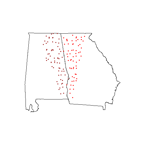
This could be applied to any pair of regions; this graphic for example, shows the parts of Georgia (red) and Alabama (crimson) that might be able to see each other. Again, we’re not taking into account any intervening terrain, so you’d have to check individual locations by computing panoramas under the “New Panorama” tab at www.heywhatsthat.com.
I haven’t put a web interface on this — i.e. let you draw two arbitrary areas on the map, click, and see colored regions representing mutually visible spots — because I can’t think of any useful applications for it. If you can, please get in touch…
My own two cents are that Michael should really get himself a blog:-)