- Budapest goes 3D: The Budapest Times reports that the city’s mayoral office is subsidizing the creation of 3D models of landmarks for inclusion in Google Earth. While the article is off when it comes to which other cities have 3D cores (see Frank’s post about recent updates) it is interesting to see how creative new ways are being used to finance putting a city’s best face forward:
Private corporations are welcome to “adopt” a district, thereby financing the production of the virtual version of the particular area.
- Tasmania councils nix Google Earth surveillance: On Tasmania, some local governments say that neighbours ratting on each other over property violations is more efficient and less intrusive than using Google Earth for policing. In which case, I suggest that tasmania’s neighbours use Google Earth to check on each other and then rat to the local council thus. I’m sure that would work even better:-)
- Google Earth Hacks goes mobile: Google Earth Hacks now has web pages that are optimized for smartphone browsers. Go to m.gearthhacks.com and you can now browse the site’s locations on a small screen, with Google Maps URLs opening in the dedicated Google Maps application on the iPhone. You can’t view overlays or 3D models on the iPhone, of course, and you can’t search (just drill down categories), but by making much of its content available to the mobile browser today, Google Earth Hacks is ahead of what I expect will be quite a big curve:-)
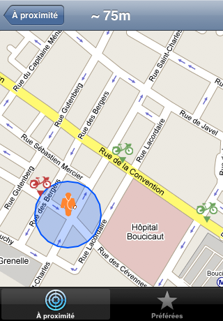
- Get on your bike: In cities like Paris, Montreal and Stockholm, you can set up an account online, then take a bike from any number of automated bike “stations”, bike around as long as you like, and return them at another station near your destination, paying cheap rates. It’s a brilliant system, but it depends on you, the pedestrian, knowing where the nearest stations are. That makes for a wonderful opportunity to exploit location-aware devices like the iPhone: GoVelib tells you, based on your location, where the five nearest bike stations are in Paris, and how far away.
- Microsoft & spatial computing: According to Microsoft Chief Research and Strategy Officer Craig Mundie, the future of computing will involve “a 3D virtual world populated by virtual presences, using a combination of client and cloud services,” writes Dan Farber on his blog, reporting from the MIT Emerging Technology Conference last week. Photosynth also makes an appearance. The blog post links to some interesting YouTube videos, well worth watching if you want to know where Microsoft thinks we’re all headed. (Via Slashdot)
- Flash Forward: For a sneak peek of what Flash can do in the realm of 3D visualization, check out some amazing demos made by the Amsterdam-based duo Barcinski & JeanJean: A panorama “photograph” where the perspective changes as you rotate left and right, 3D pong, a wave generator and a 3D line you direct yourself. Not GIS-related, but surely this is fertile grounds for inspiration. Here is their blog.
- Hosted satellite imagery for gov: An interesting business idea, as reported by New Zealand’s Computerworld:
Wellington GIS specialist e-spatial and valuation and property information company Quotable Value are setting up a hosted service for satellite imagery for central and local government.
All of New Zealand is available in 50cm resolution direct from the companies’ servers, instead of agencies needing to acquire and maintain a copy themselves. Why not just give it to Google and work off that? I suspect the licensing is more amenable to government, though the service is still NZD 70,000 a year (USD 50,000, EUR 33,500). Also: How come the data is available as WMS but not KML?
7 thoughts on “Links: Budapest 3D boost, Google Earth Hacks mobile, bike finder”
Comments are closed.
Hi Stefan,
another cool news… the update from IGiGLE
http://lac-conakry.blogspot.com/2008/10/igigle-mis-jour-o.html
Not to hijack your comments thread, but I couldn’t let this post pass without mentioning that Google Sightseeing has had an iPhone optimized site since January. It’s all the rage you know ;)
http://m.googlesightseeing.com/
unrelated to your post, but interesting article you might want to take a look at
http://www.theglobeandmail.com/servlet/story/RTGAM.20081003.wlmapmakers03/BNStory/lifeMain/home
Interesting article.
regards
GIS Service provider
Following the Budapest 3D tread… Stuttgart receive a “3D lifting” from CityGML
Stuttgart 3D
I think I’m the first to blog about this :o)
Following the Budapest 3D tread, CityGML give Stuttgart a 3D lifting :o)
Stuttgart 3D
I think I’m yhe first to blog about this :o)
Oops…. You gonna think that I’m a sort of geospammer :o)
Sorry Stefan…