Google Earth imagery update: An appetizer

The list of recently updated imagery for Google Earth is above all a feast of developing-world content. Here is an entirely subjective mini appetizer:

The whole of Southern Africa is now at 2.5m resolution! Which means it is time to revisit that wonderful Namibia photo layer, and also the global shipwreck layer.

The little-known but spectacular Simien Mountains National Park, very much the highlight of a recent trip to Ethiopia, now gets a new tranche of DigitalGlobe imagery (near Debark). It’s over here — turn on the Panoramio layer to see some very cool photos in the vicinity.

Syria gets some new content too — a tile that includes the site targeted by Israel’s air raid last September, but also the walls of the old Roman frontier fortress of Halabiya:

Halabiya.jpg

Further south along the Euphrates, the important site of Dura Europos is now in high resolution — an important Roman city with remarkably preserved frescoes.

That’s just really a minuscule part of the update: Chile, North Korea, New South Wales, Western Australia all get 2.5m updates across all or large parts of their territory, for starters… The complete list is below the fold.

Continue reading Google Earth imagery update: An appetizer

Links: Seero does KML, Viewfinder, chip design in KML

SpaceNavigator + Second Life: A minireview

Today came the announcement that in a few weeks the free Second Life client (Mac, Linux, PC) will add native support for 3DConnexion’s SpaceNavigator device for navigation and object manipulation. I’ve had a pre-release version of the software to play with for the past couple of days. The improvement of the user experience is on par with how it felt to first use the SpaceNavigator on Google Earth — i.e. it’s a revelation.

That’s good news. All of us who work with Second Life know that the program could well use a more intuitive user experience — the relatively steep learning curve is currently the program’s biggest impediment to becoming a mainstream global client for virtual world-based tasks.

What interesting is that there are in fact three modes for using SpaceNavigator in Second Life, each one useful for a specific task. I’ll call them:

  • “Second Life mode” — You act on the avatar with the device.
  • “Google Earth mode” — You leave your avatar behind and navigate a sim as if it were a close-up view of Google Earth.
  • “SketchUp mode” — when building, you manipulate the object you have selected, much as with a CAD program.

The fact that all these modes make sense at one point or another in your Second Life session points to the extraordinary versatility of the program. The challenge has been to not smother people with Second Life’s complexity. The SpaceNavigator cuts through the clutter by making the most important parts — movement & navigation — completely intuitive. That said, I think that the main people buying a SpaceNavigator for Second Life are going to be the hard core master builders rather than the casual surfer.

Here is a video of the SpaceNavigator being demonstrated in Second Life:

And lest you think that this post is off topic…

Activist layers: Greenpeace, UNICEF, World is Witness

A couple of new layers are up on Google Earth today.

Greenpeace: One is a new Greenpeace layer showing those places that environmental organization is active. Google Earth Blog has this one covered. [Update: Official announcement by Greenpeace]

UNICEF: Another is a new UNICEF layer showing off its projects. It comes with an innovate new hack: tab functionality inside the placemark popup. Okay, it just looks like a tab — I think what is going on is that there are two placemarks at the same location, and that the “tab” links refer to each placemark’s popup in turn. The hack is that one placemark has no visible icon, so you don’t have choose between closely spaced placemarks when you click on an icon. Check it out — you’ll see what I mean. Very clever.

rwanda12.jpg

World is Witness: And then there is a layer for World is Witness, a major new effort by the United States Holocaust Memorial Museum.

The Google Earth layer accompanies the geoblog of the same name, and which tells georeferenced stories of people facing the threat of genocide and other crimes against humanity, primarily in Africa.

wiw.jpg

Inspiration definitely came from the Gombe Chimp Blog, but Michael Graham, one of the driving forces behind the USHMM Darfur Crisis layer, pushed World is Witness to become something that can aggregate all sort of media into a georeferenced post: text, photos, podcasts, video and even KML files attached to posts, pinpointing places or routes mentioned in an article. This makes the blog a very versatile tool for getting news out quickly about changing events on the ground, using every media that a modern-day field reporter might have at their disposal to make reportage much more immediate and nuanced for the reader — not just on the web but automatically for Google Earth too. No tropes here. (Disclosure: I was marginally involved in the discussions that produced this geoblog.) (Update 2008-04-07: Official announcement)

The official announcements should have more info. I will link to them as they appear.

How a US general wants tougher controls on the world’s commercial satellite imagery providers (but only over the US and its allies, haha)

‘Google Earth’ a Potential Space Threat is the ominous title, dated March 14 2008. Where might this shot across the bow come from? Nationalist-conservative hacks in India? Irate Bahraini princes? A desperate despot in Zimbabwe?

Try the news on Military.com, “the largest [US] military and veteran membership organization”. The article’s uncritical tone centers around this paragraph:

Lt. Gen. Michael Hamel [who manages space and missile systems development for the Air Force] told Military reporters at a March 11 breakfast meeting in Washington he is pressuring [US] domestic licensing authorities to force satellite imagery providers to reduce the resolution of their images in areas where American troops are engaged, or to delay their image feed so that an adversary can’t get up-to-the-minute information on U.S. and allied military moves.

Who gave him the right to try to dictate public policy like that? Hamel seems to have forgotten that US law already gives the government “shutter control” over US commercial remote imaging companies, preventing them from taking images of US troop maneuvers or sensitive deployments and determining the timing of their release. It’s Hamel’s job to abide by that policy, not to concoct one he’d prefer and try to ram it down the throats of civil servants.

What’s new is that Hamel would like to be able to arbitrarily reduce the resolution of satellite imagery. One reason such a constraint has never been placed on US imagery providers like DigitalGlobe is that other non-US commercial providers would sell it instead, and legally so, not being bound by US law. Hamel knows this, of course, and that’s why he comes up with this splendidly exceptionalist counter-argument:

But international commercial operators who aren’t beholden to any U.S. laws might balk at protecting America’s security interests in the face of cold hard cash. [The bastards!] So Hamel hopes to either beat them into space and edge them out of the neighborhood, or cajole them into sticking to the American licensing standards.

“It’s part of our national interest to ensure that we set the conditions not only for U.S. companies but also set some of the norms in terms of how systems on an international or allied basis are used,” he added.

Ironically, the Indian government is trying to get the UN to do something just like it, except for all counties, not just the US. Then we’d just have to ask North Korea or Sudan for permission before taking a snapshot of their dirty laundry. Perhaps Hamel is angling for an ambassadorship in New York?

PS. Hamel isn’t the first one trying to put the genie back in the bottle. Back in May 2007 the director of the US National Geospatial-Intelligence Agency (NGA), Vice Admiral Robert Murrett, attempted something similar, despite there being a clear and generous US policy in place promoting the widest possible distribution of imagery for the common good.

A critique of satellites, critiqued

It’s fun to come up with a thesis and then squeeze the facts to make them fit. it might even be fun to listen to. But is it any use beyond polemics as entertainment? We Make Money Not Art‘s Régine Debatty covers a talk by Lisa Parks from the Film and Media Studies at UC Santa Barbara about the social impact that satellites have had, including how they have affected our perceptions of conflicts. She frames her questions thus:

How have satellite images been used to represent global conflicts in the public sphere? Where does the authority to use and interpret satellite images come from? What kinds of phenomena and events do satellite images represent? Have satellite images increased public awareness and knowledge about global conflict? How have practice and meaning of “intervention” changed in the digital age?

There is a lot of potential there. Parks looks at the historical use of satellite imagery to influence public opinion, in Rwanda, Bosnia and in the run-up to the last Gulf War. Google Earth makes an appearance, and so does the United States Holocaust Memorial Museum’s Crisis in Darfur layer, but this is where I think she draws flat-out wrong inferences. Do read the whole thing, but I’ll quote part of Parks’s thesis (as dictated by Régine) and then comment.

Since 2005, Google Earth presents us with a “mosaic’ed” version of the world using satellite images coming from various sources. But while the logo of Google is always clearly visible on the images, no matter how blurry they are themselves, we are kept in the dark regarding the satellites used to compose these images. Google Earth is a great opportunity to educate the public about satellites but instead GE tends to almost erase the existence of the satellites.

No information about satellite imagery in Google Earth? Actually, read the very next paragraph:

DigitalGlobe provides date information for satellite images that are part of Google Earth using color-coded squares and “I” icons. By clicking on “preview,” you enter a meta-browser featuring the single satellite image captioned with information about how to purchase it or others from DigitalGlobe. DigitalGlobe is thus providing date information as part of a marketing strategy. GE becomes a billboard.

So, in fact, you do get satellite imagery metadata after all, but now it’s called marketing? (Meanwhile, Spot Image has similar information available.) I agree that there is not enough metadata about the imagery in Google Earth, especially the aerial imagery, but surely what is there is sufficient for basic forensic neogeography, and it is much better than nothing.

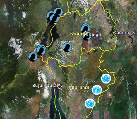
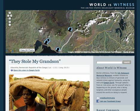
Google Earth teamed up with the United States Holocaust Memorial Museum to create the Crisis in Darfur mapping initiative which collects and diffuses visual evidence of the destruction in Darfur.

On the surface it looks like an admirable project but in several ways it missed the opportunity to represent the conflict in all its complexities. It uses tropes to represent African tragedy (images of suffering children carried by their mother). There is no visible effort of providing a political and economical education about the tragedy.

I was (marginally) involved in helping to make that layer a reality. Tropes? I saw some of the imagery that didn’t make it in — plenty of corpses bloated in the heat and charred skeletal remains. But Google Earth is used by children, and so what you see is necessarily a PG version of the humanitarian crisis. As for not making an effort to provide a political and economic education — that’s not what was lacking. What was lacking was a geographic education, and this layer has done a good job of driving home the scope of the crisis using the best free canvas available.

With the slide i pasted below, Lisa Park claims to demonstrate that earlier media news provided more opportunities for education:

0aaeclipsingsatima.jpg

Image by Régine Debatty

My comments: DigitalGlobe and Spot Image do both date their imagery. Spot Image dates it to the nearest second. And the major omission by Parks, in my view, is not mentioning that post-Google Earth we are much less at the mercy of governments feeding us their own interpretations and unique views. Back in 2003, we were not able to counter Colin Powell’s presentation to the UN regarding the existence of WMDs in Iraq. These days, we can make our own investigations about similar claims in Syria.

Problems of GE Crisis in Darfur layer:
– obscure satellite imagery,

??? The high-resolution imagery is mostly DigitalGlobe imagery, with dates provided. There is always credit given for all the imagery visible in a Google Earth view, at the bottom of the screen.

– represents the “past perfect”, because it show what we monitored from space but didn’t do anything about at the time,

How does this argue against the layer? It argues for it and Google Earth having existed sooner, so it might have spurred public support for intervention sooner.

– involves the branding of global conflicts (no matter how blurry the image, the Google brand is always conspicuous),

Right, shoot the messenger. Analogous claim: Microsoft brands the Holocaust because you can visit websites about it using your computer while the Internet Explorer logo is showing in the browser and the Windows logo on the Start menu.

– exemplifies neoliberalism (David Harvey) and disaster capitalism (Naomi Klein),

I can only speculate as to what she means here: Does she mean to say that these images are more prone to make us intervene, and by doing so we would import a western capitalist reconstruction industry that would breed dependence on aid and western loans? And that it would thus be better not to show satellite imagery of burned villages, as otherwise the danger is that we’d move to prevent massacres, thus making things worse by involving capitalism? At this point, I quickly double-checked the talk was not given on April 1.

– from CNN effect to Google Earth effect? In order to get world attention will an event have to appear on Google Earth?

Would that be so bad? Google Earth is a browser, not a channel; and it is a canvas onto which anyone can publish their own unmoderated geospatial content for others to view. It’s remarkable how Parks completely misses the real revolution that is Google Earth: Zero-cost low-effort content generation and publishing (and even hosting) for all users via KML, accessible to hundreds of millions of viewers and billions of web clients via Google Maps.

What does it mean for a US corporation to reproduce foreign territory as they want and without asking permission (some nations actually complained that GE causes a serious security concern.)

What is so special about the nationality of a corporation? Spot Image is French. The Russians also sell imagery. Is commercial remote imaging by a US company somehow more ominous? On the contrary, until Google Earth, such imagery was largely the domain of big-country governments, their militaries and proxies, without opportunities for citizens to check and balance the games played by the big boys. Today, we have volunteer-generated layers of all the world’s surface-to-air missile sites, and ones pinpointing North Korean prison camps. Is the fact that the widespread availability such information was facilitated by US companies operating in a capitalist environment so repugnant to Parks that she prefers to side with the opaque autocracies of the world, who see transparency as a threat to their authority? Google Earth levels the playing field in favor of the little guy, of every nationality. It makes the world a more democratic place, and yes, we largely have an American-owned initiative to thank.

In a nutshell:

The public remains relatively uninformed about satellites, their uses and their impact on everyday life even though citizens taxes subsidize satellite developments.

If anything, the phenomenal success of Google Earth has finally brought discussion about remote surveillance somewhat into the mainstream. For the first time ever, last year, the launch of a new DigitalGlobe satellite became a mainstream news item, largely because its imagery is eventually destined for Google Earth.

And re taxes: I don’t know if DigitalGlobe gets tax subsidies, but Google certainly pays taxes; and it was Google’s decision to start buying and making freely available all this satellite imagery over the past few years that spurred this present revolution — not anything DigitalGlobe did (other than to agree to sell to Google on such a massive scale).

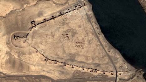
PS: Just noticed that the site of the Israeli bombing raid in Syria just became hi-res with this latest update, dated April 1 2008. Imagery is from August 18, 2007, courtesy of DigitalGlobe’s metadata layer — just a few weeks before the raid took place. Detail is much higher than anything we’ve seen until now. The new imagery is not yet available in Google Maps, but from there you can click through to Google Earth.

Sneak peek: CitySurf Globe

Late in 2006, Adil Yoltay and a small team of developers in Turkey wrote in to show off CitySurf, a 3D city viewing application for PCs with support for textured buildings that was the best in its class at the time.

The CitySurf website for that version of the application is still up, but that doesn’t mean that Adil and his crew have been standing still. This week, they sent me the newest version of the application, CitySurf Globe. It’s a true virtual globe (in that it shows the entire Earth in 3D relief, not just a small region) and I took it for a spin. It’s not ready for release yet, but they were happy for me to blog it. It turns out to contain some very innovate ideas. Here are some I like:

csgoverview.jpg

First thing to notice is that the UI has gotten a lot slicker, simpler, and is in English. (No more guessing at Turkish:-). They’ve also got a very nice take on the compass/controller: Nudging the ball in the middle doesn’t move the point of view as others do but instead rotates and tilts it simultaneously. I like it.

But what I really like is when an obviously good idea appears: The option to search just the visible region instead of the entire world. It happens often to me when searching for a specific place in Google Earth, say for a town in Egypt, only to suddenly find myself flying to Indonesia to a similarly named place that I wasn’t looking for at all. CitySurf Globe fixes this problem:

csgsearch.jpg

Also news is that CitySurf Globe has grown much more webfriendly, incorporating georeferenced Wikipedia- and weather sources. Most impressive, it can parse and display GeoRSS feeds — something that’s been promised for Google Earth for nearly a year, but is still not available there.

csggeorss.jpg

csglayers.jpg

One reason that Adil was happy for me to blog CitySurf Globe is that they are still looking for sponsors. They have an efficient rendering engine, he says, but the small team can’t afford good global datasets. If you’re looking for a base onto which to build your virtual globe empire, you can always get in touch with them…

csginfo.gif