Some innovative KML content hit the web this past week while I took a family break (with results to show for!):
- Mybabytree.org: Pay WWF to plant a sapling in Indonesia’s Sebangau National Forest, get its precise coordinates as a KML. A steal at only US$5.50, especially if you don’t get paid in US dollars:-) Here’s the KML network link I got back when I bought a tree — I’m sure it will take few days before mine gets added:-)
Just some feedback: Where is the non-Flash version of the site? I kept on wanting to “skip intro”. I think more baby trees would be born if impatient people got to sponsor them too:-). (Via All Points Blog)
- Craig Stanton on Seero: Live and on-demand video geotagging site Seero (previously blogged here) has emerged from private beta and is now accessible to all. One early user is Craig Stanton, author of iPhotoToGoogleEarth and an avid trekker. He’s posted his georeferenced videos of his walk from Mexico to Canada along the Pacific Crest Trail in 2007.
Craig’s content focuses our attention on Seero’s revenue model: On-map pointers to “factoids” that include ads:
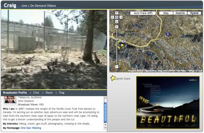
I haven’t decided if this is overly intrusive or not, or whether I’ve just developed a blind spot to Google ads. (Or perhaps Google ads feel more relevant and hence feel less like ads and more like useful information?) Still promised by Seero’s developers: A KML feed.
- Global historical temperatures: Really nice find by Frank at Google Earth Blog: Global Temperature Station Data in Google Earth, dating back to the 19th century and beautifully charted in placemark pop-ups, with trend analysis. (I assume you read his blog, but adding it here just in case.)
- Improved KML labels: Never content to leave good enough alone, Valery Hronusov creates a web-based application for the automatic building of labels in KML.
A roundup of neogeo stuff that caught my attention in the past week or so:
- Impact news makes an impact down under: News about Hickman Crater hits the mainstream media in Australia, with an article in the Sydney Morning Herald… and the paper gets it! Accompanying the article is a 100% genuine interactive Google Maps view of the crater. Kudos SMH.
- Neogeo in print: Digital Urban‘s Andrew Hudson-Smith is coming out with a glossy-looking booklet, Digital Geography – Geographic Visualisation for Urban Environments, collecting “insights and tutorials on Virtual Earth, Google Earth, Google Maps, Panoramas and Second Life.” It’s a teaser for a thicker tome due out at the end of the year. I’ve got one reserved.
- FlickrExport 3 gets geosavvier (Mac): FlickrExport for iPhoto and Aperture, a plugin for exporting photos to Flickr (duh), already lets you turn the coordinates of the current view in Google Earth into Flickr geotags. Version 3 (Beta) now lets you integrate GPS tracklogs and add coordinate presets (for multiple photos at the same spot). But when oh when will somebody let me add or alter coordinate metadata in Aperture’s library of photos?
- Camera GPS shopping list (and wishlist): The Map Room points us to a review of a new GPS unit for Nikon’s pricier DSLRs: The Solmeta DP-GPS N1. Verdict: Works well. If you’re in the market (like me), also check out this forum thread over on Panoramio, where several more competitors are referenced. The field is getting crowded, and that’s a good thing for us consumers:-)
Still, what I’d really really like is a normal GPS unit that I can sync with my camera at will before I offload my photos to the computer. A GPS unit really doesn’t need to be connected to the camera all the time now does it? And surely this is something that Nikon and Garmin can arrange amongst themselves, no? All I’d need is a mini-to-mini USB cable and firmware upgrade (or two).
- New Virtual Earth 3D Blog: Virtual Earth 3D is a blog “kept by the Microsoft 3D Integration team in Boulder Colorado.” (Via Angus Logan’s Blog)
- VE Imagery update: Microsoft Virtual Earth gets 43 TB of new data for March. That link has the list.
- Google I/O: Google I/O, a new developer event slated for May 28-29 in San Francisco, has a “Maps & Geo” component. $300-$400 for both days, or $50 if you are a student.
- ArcGIS 9.3 Server hearts KML: ESRI ArcGIS Server 9.3’s REST API supports KML natively. If it is going to be this easy, can we expect the floodgates to open re KML content from GIS pros?
- MapQuest hearts KML: mapQuest’s JavaScript API supports KML. Seriously. Here’s how.
- GeoRSS+?: Andrew Turner discusses improving GeoRSS so that it can represent collections of geospatial objects, which is useful when narrating a story that references more than one location. Sean Gillies isn’t convinced of the need to upgrade. Debate ensues.