GPS + Wiki = TierraWiki

Tim Park writes in about TierraWiki, a new project of his that looks slick and sounds promising:

I thought I would write as I am working on a project that blends Google Earth with Wiki technology for outdoor enthusiasts that I thought that might be interesting to your readers. The humble goal of my site, TierraWiki, is to create the most complete reference to the outdoors in existence.

The wiki is based off of the same MediaWiki technology as Wikipedia but I have built extensions to

  1. be able to use the GPS track information from our outdoor activities to build a comprehensive trail map that you can access not only on the web but also through Google Maps and Google Earth,
  2. enable location based search to make it easier to find outdoors information in the vicinity of another location, and finally
  3. have exposed a Google Earth network link that allows you to always have the latest trail map in Google Earth as well as articles that are geotagged.

Basically, I ask that the community go out and use the outdoors on their favorite trails and then upload their GPX tracks to build the trail network. I then have some algorithms that I am working on that can merge this track data, and eventually, will let users plan outdoor trips and have a look at just what they are getting into across the web and Google Earth before they do it (nothing is worse than finding that “extra mountain” on your mountain bike ride).

Here is an example track page, and here is an example of a composite trail map. Finally, here is the TierraWiki network link containing all the trails in its database. Each individual trail is also downloadable as a KML file.

tierrawiki.jpg

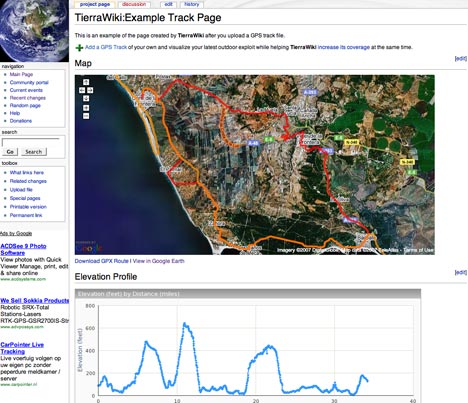
I especially like how it is possible to upload and show elevation and speed data from the GPX file. Wikipedia now has many of its articles georeferenced, but with TierraWiki the geospatial savviness goes the other way — you start with the geospatial data, and then you mark it up semantically with maps, photos and/or a description.

There are of course other good GPS community sites out there, but TierraWiki differentiates itself by using a wiki content model to assimilate information, as opposed to an account/login model. It’ll be interesting to see which proves most popular in the long run.

Virtual Shanghai coming by 2010

Shanghai Daily comes out with this news item today:

Digital map to provide 3D view of downtown

By Zhang Jun 2007-2-10

BY the time the World Expo opens in 2010, travelers will no longer have to visit the city in person to enjoy a three-dimensional tour of its downtown core. They will only have to boot up their computers.

The city plans to create a digital, three-dimensional map of Shanghai that can be easily searched online. The project will be similar to Google Earth, a site that lets you study satellite images of the planet, but will provide an even better look at the city’s architecture, according to Shu Rong, a researcher with the Shanghai Institute of Applied Physics, which will provide airborne camera technology for use in the project.

Users will be able to view the map using a PC or cell phone.

“The map will provide a vivid city tour,” Shu said, noting it will include pictures of the sides of buildings, unlike the Google site which only provides a birds-eye view of cities.

A couple of comments:

  • Just as when France’s IGN decided to come to build a custom viewer, Géoportail, to depict its imagery of France, you have to ask: Why chain content to a specific delivery mechanism? Wouldn’t it be better if IGN and the Shanghai city government made their datasets available in an open format, viewable with a range of virtual globes? Isn’t the whole idea to disseminate this information as widely as possible? Imagine coming out with a special browser exclusively for your website — it doesn’t make any sense.
  • You can bet your bottom dollar that this content will be censored, just as GéoPortail’s is. Then again, censorship seems to be something Google Earth is no longer immune to either.
  • 2010 is far off. Google Earth already today lets you show 3D buildings, as does Microsoft Virtual Earth 3D. The mind boggles when I consider what virtual globes will be capable of in 2010, especially considering the rapid rate of development we’ve seen over the past 18 months.

(Thanks to Robert Jacobson for the heads-up.)

Terrorist propaganda video shows off Google Earth imagery

Il Corriere dela Sera, a serious italian newspaper, has an article out today about a potential terrorism campaign that might be conducted by Tunisian Al Qaeda-ists in the run-up to the French presidential elections.

It quickly gets interesting for Ogle Earth readers when the article links to an Al Qaeda propaganda video, apparently documenting this attack on a bus carrying expats in Algeria on December 10. About one third of the way through, you see a screen that clearly shows images taken from Google Earth, with somebody scoping the scene of the attack. Interestingly, what the propaganda video shows is stitched screenshots, rather than Google Earth running:

terrscreen.jpg

terrscreen2.jpg

[Warning: the video ends with footage of the actual bombing — as if you needed reminding of the sick glorification of violence these people engage in.]

You can of course never take anything you see in this kind of video for granted; the intention may be, in part, to ensure we lose unfettered access to information as yet another consequence of their attacks.

Il Corriere‘s article mentions other instances of aerial mapping being used by terrorists and militants, some of which I haven’t seen documented before: Images “taken from the internet” of western embassies in Tunis, recovered from Tunisian militants; the Basra affair, which prompted Google to roll back its image update to before the Iraq war, images recovered from an Al Qaeda hideout in Fallujah, apparently showing targets in Europe, and aerial imagery found in an abandoned Hezbollah outpost during last summer’s Israel-Lebanon war. Hezbollah’s imagery was shown not to be taken from Google Earth. Il Corriere missed this one: A foiled attack in Yemen. Note: Except for the Hezbollah story, all original sourcing for these stories is unavailable — there are no means to verify independently the claims of any of the actors in these conflicts — and in war, truth is expendable.

Links: Australia gets directions, Fledermaus gets KML

  • Google Earth now has addresses and directions for Australia, though no roads (as of yet). Doing a search for the place where I used to live Sydney proved spot-on:

    belevuehill.jpg

    (Thanks to Michael Smalley)

  • Kurt introduces me to yet another 3D visualization system — IVS3D’s Fledermaus. It seems to be particularly suited to viewing and manipulating bathymetry data, and even comes in Linux and Mac versions.

    Kurt also shows off a new feature in the latest version, 6.4 — exporting to KML. His screenshots and explanation are worth a look. (No info on pricing for Fledermaus, so I’m pretty sure I can’t afford it.)

  • eZ publish, which I had not heard of before, is a Norwegian open source content-management system. Bjørn Sandvik used it to create KML templates, and you can see the resulting KML-savvy web pages here (in Norwegian).
  • Google Earth Blog highlights an innovative way to bring in-world video to Google Earth via clever use of the timeline.
  • NASA World Wind 1.4 is due on Valentine’s day. Aw.

CyberCity: More 3D cities coming to Google Earth

This article was online, disappeared, but has now shown up again: Switzerland’s NZZ Online profiles CyberCity, the Zurich-based company behind the (impending) 3D version of Hamburg in Google Earth. Choice excerpts:

[Google] has already snapped up a three:dimensional model of Hamburg from the Swiss creators and has now asked them to supply more cityscapes with levels of detail currently unavailable on Google Earth. […]

“We are confident that we can have a productive relationship with Google in the coming years,” said [CyberCity managing director Franz] Steidler. “This is quite a breakthrough for us.”

The company already has a stockpile of some 50 cities mapped out in 3D detail in its database, including Paris, Salzburg, Florence, Los Angeles, Chicago and parts of Zurich.

“We will get a list from Google of what they want from us,” added Steidler.

What’s interesting is that the original initiative for putting CyberCity’s 3D Hamburg into Google Earth came from Hamburg’s local government and businesses, not Google; though now it seems that CyberCity’s other offerings have caught Google’s eye.

Clearly, the competition that is driving both Microsoft and Google to ever-greater lengths to impress users is unequivocally a Good Thing ™ for us:-)

Yahoo!’s Pipes — The universal mash-up engine

logo_1.gifToday I’ve been eagerly waiting to get into Pipes, Yahoo!’s most excellent-sounding universal mashup engine — and so has everyone else, as it’s been down ever since I heard about it on TechCrunch. (Maybe it’s because Tim O’Reilly called it “a milestone in the history of the internet.”:-)

As I haven’t actually had a chance to play with Pipes, I’m not going to describe what it is, instead leaving that to these two great examples (one and two) by Kevin Cheng.

I don’t think Tim O’Reilly is dabbling in hyperbole. For neogeographers in particular this will be something of a big bang, I suspect.

How? For starters, Kevin Cheng’s examples output GeoRSS by default, and the entire “pipe” is geospatially enabled.

Second, KML support is coming! From Yahoo! ! Check this out:

While Pipes today lets users mix data from RSS and Atom feeds, Yahoo hopes to extend the service to support other data formats, Web services, processing modules and output renderings, Yahoo said. For example, Yahoo will open up access to the Pipes engine to programmers and add support for the KML data source, which is used to display geographic data in Google’s popular Google Earth mapping application and Google Maps website.

Start combining this with the power of the network link and we’re suddenly at a whole new level of mashing — where decision engines, inputs and formatting are all turned into interchangeable web services. This is much more than what XSLT stylesheets can do to XML.

I can’t wait to see what GIS pros and amateurs come up with:-)