Doctored Aussie tourism ads get flack

Here’s another cautionary tale, lest you’re a tempted to engage in false advertising regarding the relative merits of your local tourist attractions. The state government of Victoria, Australia, is running a campaign promoting the Geelong waterfront with satellite images… except that the images were doctored. The Geelong Advertiser caught them:

GRAPHIC.jpg

Here, by comparison, is how the view looks in Google Earth:

geelong2.jpg

That’s Digital Globe imagery from 2004, and it’s clear the ad is based on something better and hopefully more recent. But nothing beats sending a reporter over to the waterfront to do a visual check. The result:

City of Greater Geelong Mayor Bruce Harwood said the council was negotiating with Tourism Victoria to change the image because the accuracy was “not quite right”.

While I think there is room for poetic license in the case of something as inconsequential as tourism advertising, it’s interesting to note that as we become savvier about the provenance and availability of such images, we also become more adamant that they convey correct information. And if you doctor images in the cause of tourism, be prepared for a backlash when your tourists actually come, and reality falls short of what you promised.

Links: US election data as KML, Garmin Mac betas, Bird’s Eye how-to

  • On his Census KML Data Visualization blog, Aidan Marcuss has been putting all kinds of US census and electoral data into KML, producing some interesting innovations in the process. For example, Here:

    I’ve also used the TimeSpan element, so you can load both the 109th and 110th Congress files into Google Earth at one time. Using the time slider you can move between the two Congresses – the effect is pretty cool.

  • More Second Life/Google Earth mashing up: 3PointD posts a cool video showing Second Life architect Lordfly Digeridoo doing rapid prototyping in Second Life for a real-world project… and if you look closely, you’ll see that the foundation is a screenshot from Google Earth.
  • Announced on the Garmin blog, Apple Mac betas for the POI Loader and Garmin firmware updaters.
  • It’s Google Developer Day on May 31, in 10 spots around the globe. Alas, that’s too close to the launch of my other project for me to make it, but don’t let that stop you:-). As Frank points out, geo developers will likely be congregating in Mountain View, CA, as that’s near where Where 2.0 takes place May 29-30.
  • Interesting analysis, first by Peter Laudati and then Scoble, on why Microsoft’s mapping projects don’t have the same visibility as Google’s. Laudati moots it’s the lack of a clear name, Scoble thinks it’s the interface. Both are correct, I think — neither the marketing nor the UI are user-centric. But there is a third thing: Google periodically lends its technology to compelling humanitarian causes — Katrina, the Pakistan quake, Darfur… Granted, Microsoft has needed to catch up technology-wise, but if it wants to make its mapping services a media destination, perhaps innovation in using its maps for the greater good is a way to go.
  • How does Microsoft’s Bird’s Eye imagery get taken in Europe, anyway? Here’s a video from the UK’s The Gadget Show. Money quote:

    By the end of 2008 they hope to have covered 900 European cities, that’s everywhere with a population of more than 50,000 people.

    (Via Virtual Earth for Government)

  • Digital Urban plays some more with the Nokia N95, using its GPS abilities to track a train journey, and visualizing the resulting KML in Google Earth.

Mediawatch: Covering the new Darfur default layer in Google Earth

Hundreds of media organizations carried news about the new Darfur layers in Google Earth — and that’s just in English. In Sweden alone, over 40 papers ran the news (an example). In the US, many local news organizations and papers ran the AP or Reuters story. Here’s a rundown of links to some of the larger and/or more interesting ones, with some observations at the end:

Using their own correspondents: The Los Angeles Times (business), BBC (front page feature), CNET (front page, and as a top headline for media 2.0), CNN (technology), Washington Times (business), PC World, ABC News (world news) and a good article/blog in Wired.

Reuters: Australia’s The Age (under technology), New Zealand Herald (world news), The Australian (world news) and Scientific American (science news).

AP: Seattle Post Intelligencer (business), MSNBC (technology), The Guardian (world news), Sydney Morning Herald (technology), the Houston Chronicle (markets), Seattle Times (world news), CBS News (technology), Baltimore Sun (world news), Washington Post (technology), San Jose Mercury News (breaking news), San Francisco Chronicle (business), Denver Post (world news), International Herald Tribune (Americas??) and the Sudan Tribune (which is a great resource for Darfur news, it turns out — pity they don’t have RSS).

AFP: Times of India (world news), iAfrica (technology) and Baku Today (technology).

IDG News service: IT World and InfoWorld.

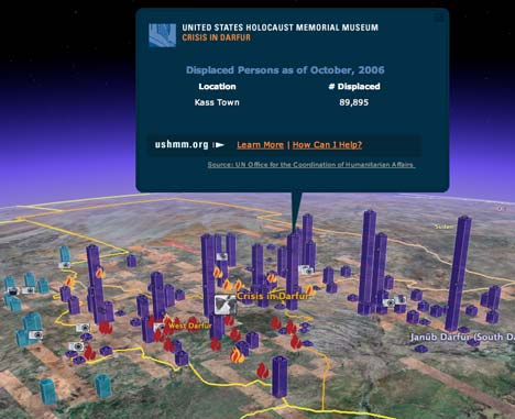
What’s interesting is that there is no consensus among news editors as to where such a story belongs: Is the story’s most important news component the fact that there is a genocide being perpetrated in Darfur (world news), that new technologies are being employed to educate people about Darfur (technology), or that Google is involved (business)? In a sense, the situation in Darfur is not itself a “news” story, in that we all already (should) know what’s going on there. (If anything, the news is that it’s getting worse at the moment, and people I know who work there are doing so without much hope of a resolution anytime soon.) But putting the story in the technology section relegates it to a spot not followed by the people that the technology is most aiming to reach.

I think this is above all a story about how new technology is letting us all be witnesses to a genocide in progress, and how that raises our own responsibilities — so perhaps this is a story best also told in the glossy Sunday newspaper magazines, read when people have more time to play with Google Earth and where there is more room for long-form stories about larger technology trends coupled to humanitarian crises such as Darfur, but also Katrina/New Orleans and the Pakistan quake from 2005. How about it, New York Times?

Darfur webcast, info pages now up and running

The live webcast and press conference launching the Darfur layers in Google Earth is now on. Check it out here, on the US Holocaust Memorial Museum’s site.

Also up and running now is the museum’s home page associated with the Darfur layers, where you can download the expanded standalone version. You can find out more specific information about the provenance of each individual layer on this page; there is also a long list on that page of people who volunteered their time and expertise to make this layer a reality, including Declan Butler, Brian Timoney, Timothy Caro-Bruce, Mikel Maron, Andria Ruben-McCool, Megan Goddard, Lars Bromley, Jeremy Nelson, Brian Steidle, Ron Haviv, Mark Brecke, Ryan Spencer Reed, Mia Farrow and Brian Flood.

Missing from that list is USHMM’s own Michael Graham, who initiated the project and whose tireless perseverance pushed this project all the way to completion, through numerous iterations and prototypes.

[Update: Here is the press release.]

New layers: US hiking, New Zealand tourism, skiing

Besides the Darfur layers, several other new layers made it into Google Earth this morning.

  • New Zealand is the first country whose tourism department has managed to get a prime spot in Google Earth, with placemarks of popular destinations that lead to the relevant websites. Now why didn’t Sweden think of that?:-)
  • The Trimble Outdoors Trips layer adds GPS tracks and imagery from user-contributed hiking trips in the US. Nice feature: You can send a trip you like directly to your web-enabled phone. If your phone is GPS-enabled, you can send it the track data instead.
  • There is a new layer called “Skiing” that shows ski resorts and ski lifts. Elsewhere, there is a new layer for “mountain railways”. All this comes together beautifully in — where else — Switzerland, where the Matterhorn is now surrounded by lots of new geospatial data:

zermatt.jpg

Google turns on new Darfur layers as default

Google Earth got a whole slew of new layers this morning, one of which stands out — literally. The United States Holocaust Memorial Museum‘s layers documenting the genocide in Darfur are turned on by default. It’s an overtly political statement on the part of Google, and one I wholeheartedly applaud.

darfurafar.jpg

USHMM has been working on bringing this content into Google Earth for a while now, and it is the kind of information that is best published to a geobrowser: Burned villages, photographs, refugee camps, testimonies… All these atrocities happened somewhere, but no longer is this place abstract. Google Earth’s high resolution backdrop makes it all immediate.

darfurwitness.jpg

The default layers link to fuller documentation, with more graphic photographs and with precise refugee numbers, which you can also manually download here. Just go take a look. It’s compelling. You will soon find more information on USHMM’s site here, and if you want to get involved, go here.

displpers.jpg