Microsoft Virtual Earth just got some new bird’s eye imagery, including of Stockholm. It’s lovely, but it also serves as a good example of where the limits of a country’s sovereignty lie, and the implications for censorship.
A cold-war era law still on the books in Sweden allows Lantmäteriverket — the state GIS agency — to censor maps and imagery of “sensitive” sites in Sweden. One example of such censorship came to light when satellite imagery in Google Earth showed the signals intelligence HQ on the outskirts of Stockholm, whereas local Swedish mapping sites showed… woods.
Why was the satellite imagery in Google Earth not censored? Because Sweden’s sovereignty does not extend into space. Countries do control their air space, so they can legally censor the collection of imagery using airplanes.
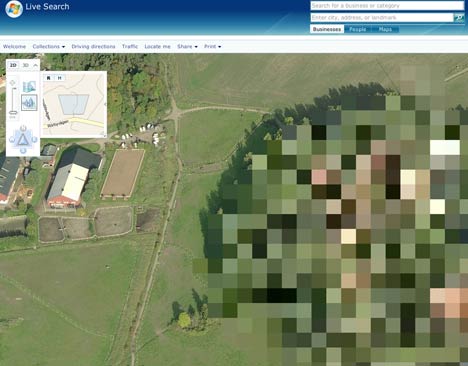
I wondered if Microsoft’s recently commissioned bird’s eye view imagery is still subject to censorship, so I went looking for the same spot. Sure enough, it is pixellated:
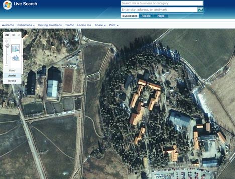
Ironically, if you switch back from bird’s eye view to the overhead view, taken by satellite, you get better resolution again:
On a positive note, Lantmäteriverket is no longer trying to camouflage its censorship, for example by painting fake trees over the buildings; this made their imagery and maps untrustworthy. The Dutch use a similar pixelation technique when they censor their aerial imagery — at least this way you know that you don’t know what’s going on there, and that’s better than not knowing that you don’t know.
Virtual Earth’s European birdeye vistas seem to come from a company called Blom Pictometry. I wrote about that recently in Spanish, as a company from Spain announced a GPS device in which navigation will be visualized using those oblique photos of cities.
BLOM’S aerial photography of London can be viewed on a new implementation called propertybird: http://www.london-executive.com/propertybird . What does the group think?