Sea ice Day, collaborative mapping, privacy and access controls

Today is Sea Ice Day — sea ice being the stuff that is disappearing so rapidly from the poles. Just like when International Polar Year was launched on March 1, www.IPY.org turned a Google Map into a geographic bulletin board, where schools or institutions participating in Sea Ice Day (conduct a sea ice experiment, why don’t you?) could leave a georeferenced note — a “virtual balloon”:


ipy2007seaice tagged map – Tagzania

Some observations:

  1. These social maps have proven very popular with schoolkids and teachers. They practically fill themselves up. They are an incredibly compelling medium because within that small rectangle on the screen is an ever-expanding canvas that draws people in. We all know this, but sometimes I get jaded because it is so ubiquitous. It’s good to be reminded sometimes about the giant leaps online maps have made in the past three years.
  2. You don’t need to use the an API any more to build a social mapping application. We had users sign up to Tagzania and then told people to tag their location with a predefined tag. We then use embedded maps on IPY.org to show all the places that have the tag attached. It costs nothing and it has quite the impact — perfect for scientific outreach projects on a budget. And the Tagzania team have been very helpful in adapting the embedded maps to display more placemarks in one go, even though we’re using their site in a way it was not originally intended for.
  3. One vulnerability: We can all agree beforehand on what unique tag to use, but we cannot control who ends up using it. Currently we can’t “own” a tag or create closed groups whose user contributions we exclusively display. This opens up the possibility that somebody might want to act parasitically, attaching “tag spam” to the map.

All this leads to a wish list for social mapping sites like the already excellent Tagzania. I would like to see advanced collaborative features such as access controls and privacy controls. Perhaps some features could be free, and some you would pay for. Letting a predefined group of contributors collaborate on making a public map might be a free feature. Giving users the ability to keep such maps private or shared with specific clients (for example, for NGOs in the field) might be a pay service. It would be nice to see the same kinds of granular privacy controls that Facebook has (just to name a topical example) and apply it to geographic data. Another example: Flickr lets you have groups that are public, invitation only (but visible) or completely private. Why not do with all sorts of georeferenced data what Flickr already does with photos?

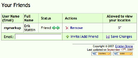
In some cases, we’re already seeing such kinds of granular privacy tools applied to online maps — especially when it comes to live tracking applications. Here is what the GMap-Track control panel looks like:

gmaptrack12.jpg

If anybody has other examples of how privacy and access controls are being implemented on mapping services sites, please do chime in with examples in the comments.

In the longer run, then, I suspect there will be more sites offering sophisticated social mapping services on top of existing mapping APIs, for inclusion on users’ own websites, so that the non-programming masses gain the use of tools that are currently only available to those rolling their own geospatial websites. The sooner that everyone’s a neogeographer, the better:-)

Google Earth gets preview layers

New today: Google Earth gets preview layers. Because too much information can be a bad thing:-)

sensoryoverload.jpg

(Via Google Earth Blog, where Frank also lists updated layers.)

Links: Cosmos Globalbase Browser, Space Shuttle sim, Barnabu’s real-sized planets

  • New geobrowser alert: The Cosmos Globalbase Browser, out of Japan. There are instructions in English, but language remains a bit of a barrier, and often I’m not quite sure what I’m supposed to be doing. Still, it’s all brand new, there appears to be open-source origins, and the premise is an interesting one:

    Is it possible to build a system that allows creating maps in a way more like the World Wide Web and delivering them through the Internet? An architecture that involves no central server, no concentration of data and traffic at any one particular place, but where any information can be delivered from any server incorporated into one single world-spanning network. Such a system can become a reality with your cooperation.

    For Windows, Linux, Mac, Solaris and FreeBSD. Perhaps the NASA World Wind guys might want to talk to them? Or OpenStreetMap?

    cosmosfb.jpg

  • Space Shuttle sim: Space Shuttle Mission 2007 is a just announced Space Shuttle simulator that comes with a drool-inducing teaser video on its home page. With a feature set that includes historical missions and TerraMetrics’ TrueEarth imagery, this looks to be a simulator verging on an augmented reality application:-) (Not out yet, for Windows) (Via FlightSimX)
  • Real-sized planets: There’s Google Sky’s built-in icons pinpointing the locations of the planets. There’s HeyWhatsThat’s icons for the locations of the planets and the Sun. Now there is Barnabu’s real-sized overlays for the planets and the Sun. Unlike icons, you can precisely control the sizes of an image overlay, so I really like this solution. I haven’t checked the accuracy, but if this pans out then you can definitely use Google Sky to go planet hunting.

    All three options do the phases of the moon. So far, Mercury, Venus and Mars do not show phases.

  • Polar data in GE: Got GIS that stretches across the poles? Google Earth can’t help you, but you can fake it by applying Gerardo64’s hack: Add your polar projection as a PhotoOverlay, like so:

    polarprojectioncz1.jpg

  • Google Maps API Blog‘s Pamela Fox touts the newly improved ability of Google Spreadsheets to geocode, and uses this wizard to turn the result into a Google Map. What all this means is that you can easily do the same and then turn that spreadsheet into KML, using Valery Hronusov’s CONCATENATE trick.
  • Oops, I did it again: Iran “accidentally” blocked Google domains on Sunday. Briefly.
  • Sailing videos: Virgil Zetterlind over at EarthNC Blog georeferenced 300 YouTube boating videos from around the world and turned the result into KML. Writes Virgil:

    This will continue to grow quickly as we process through YouTube and other sources and hopefully start to get link submissions via our forum. Part of the exercise has been in working out a simple user-interface to review and geotag the videos (given that it will be a while, or possibly never, before we can fully rely on up-front geotagging by the authors).

    (For PC; For Mac and Linux click on the link through to the YouTube page and watch it there.)

XML. Or, the coming transformation of observational astronomy

After a series of posts documenting the process of converting the contents of the Ukraine Russia Radio Telescope Database into KML, L. Van Warren posts the results (Direct link to the KML file for the impatient). And it sure is pretty: The locations in the sky of 1855 prominent radio sources, including 118 quasars, with relative radio brigtnesses depicted by circle size:

pinkdots.jpg

closeupradar.jpg

It’s fun to go see if a particular source also has a visual component — it isn’t always the case.

So why was Van’s task so Herculean? Because the raw data looked like this:

rawcomet.gif

It takes quite a bit of regex gymnastics to turn the above into KML that looks like this:

nicedata.jpg

The Ukraine Russia Radio Telescope Database is not the only place where data is available online but in a format unfriendly to machines. The Aerith site, which houses a wealth of ephemeris data on comets, has a similar handicap. Click through to an individual comet to see the orbital data in a space-delimited format, with the actual positions generated for you in a graphic.

This is how astronomical data has often been shared in the past, but not how it will be shared in the future. There is a better way: XML.

This is not a new idea. We’ve already run into the Virtual Observatory Event (VOEvent) XML specification, and over on Astronomy Blog, Stuart is working on an XML schema that would allow telescopes to have “an RSS-like XML feed” showing what’s been viewed and when. Oh Inverted World blog gets it immediately:

There are a myriad of benefits to such an approach, the main one being that it will be easier to collaborate globally on projects, particularly those which can be aided by numerous observations and ancilliary data.

What’s changed recently is that there is now an astrobrowser, Google Sky, that is can understand and render XML. KML descriptions of astronomical objects are now a simple XSL transformation away from any other XML format, such as VOEvent XML or Stuart’s XML. As a consequence, the incentive to provide machine-readable astronomical metadata instead of text tables just got a lot stronger. There’s no more need to peer at static charts — just load the data in Google Sky, and mash it up with anything else you like.

In an ideal world all such observational astronomical data would exist in a machine-readable markup format, and I’m willing to venture it soon will. Just as it took the geospatial web a year or two to re-orient itself towards making its data available in a format compatible with KML, the astronomical web will take a while to provide its data in a similar format.

But I have little doubt that in the very near future, you’ll be able to download position data for all new comets as KML, which in turn has been generated on demand, perhaps as a network link, from ephemeris data provided as an RSS feed. And who will come up with the astronomical equivalent of Panoramio, where amateur astronomers can upload time-stamped comet imagery? Imagine being able to chart the progress of a bright comet in Google Sky over the course of a month by playing in quick succession the accumulated contributions of hundreds of amateur astronomers. I can’t wait to see it:-)

Links: Google Earth bugfix, Burning Man, 3D Route Builder

  • Google Earth bug fix: Google Earth gets a bugfix update, to v4.2.0198. From the release notes:
    • SpaceNavigator support for sky. [Works on the Mac:-)]
    • Fixed several crashes in PhotoOverlay
    • Reverted “Restrict time display to folder” checkbox default to off
    • Fixed inadvertent photo flip for sperical PhotoOverlays with tilt less than 90
  • Burning Man: Valery Hronusov posts the KML file of the aerial shots over Burning Man 2007.
  • Bluetooth GPS for Nikon: This looks like the best solution yet for turning Nikons into GPS-enabled cameras: Red Hen SystemsBlue2Can, a bluetooth adapter. I want one.
  • 3D Route Builder for Google Earth “is a powerful utility for fine grain control over paths directly in Google Earth. These can then be either built from scratch or based on existing KML or GPX exported and then driving the route at specific speed.”
  • WorldView launch: DigitalGlobe is launching another orbiting camera on September 18 — WorldView I, reports Reuters. See the launch live here. Weird tidbit:

    DigitalGlobe built the satellite in part with $500 million in funding from the Pentagon’s National Geospatial-Intelligence Agency (NGA), but it can sell the images commercially as long as their resolution is no sharper than a half-meter.

    Says what law? I thought the only country for which US laws set resolution limits for imagery sold by US satellite companies was Israel. Or is this half-meter limit a new licensing restriction for WorldView? In any case, down the line this satellite and WorldView II will likely result in more frequent, more accurate updates for Google Earth.

  • DrupalCon: It’s DrupalCon Barcelona 2007 on September 19-22, and Dan Karran will be there, touting Drupal as a GeoCMS.
  • Nokia 6110 with GPS review: Steffen Nork tries the GPS tracking on the Nokia 6110, and likes it. On a related front: Ever since switching to Vodafone here in Cairo, the assisted GPS on my Nokia N95 is impressively quick — I’m getting a lock in seconds, and with partially obscured skies! Suddenly, the GPS on this phone is usable. It seems that your phone company provider makes a big difference in this regard.
  • New Virtual Earth developer blog: Hannes’s Virtual Earth Blog (Via GIS Lounge and Virtual Earth / Live Map)
  • ArcGIS Export to KML: James Fee has news of a update to Export to KML, version 2.4, for ArcGIS.
  • KML to GeoRSS: In a reversal of how the production flow usually goes, BRIGHTi Geofeeder takes KML, Shapefiles, GML, Mapinfo or Autodesk files and converts them into GeoRSS. Free demo. (Via Virtual Earth / Live Maps)
  • Google Maps upgrade: 54 more countries get data in Google Maps. Google Earth has had the populated places for a while, but now Google Maps is ahead in terms of road coverage. No directions from Kabul to Kandahar, however:-) At least not yet.
  • Rocket Garden Visualizer: Google’s Lunar XPrize website contains one pedagogical tool that uses Google Earth. Give the form an address, and you get a KML file back depicting life-size scale models of various rockets. Put them next to historic landmarks to get an even cooler context:

    pyrarocket.jpg

Links: Homework, Google Moon, Assyrian skies

  • Fantastic story: Julian Bencito goes way beyond the call of homework duty, enlisting Google Earth’s help. And thus the virtual once again becomes real…

    01.jpg

  • Google Moon. (Via Lat Long Blog). A version for Google Earth is on the way, says the FAQ. Bull’s Rambles argues that NASA World Wind has had this for a while. Still, Google Moon’s datasets are detailed, delicious and accessible.
  • Old Skies: We’re used to historians and archaeologists using KML to mark sites of interest. One web resource went a bit further: Knowledge and Power in the Neo-Assyrian Empire also shows you Assyrian constellations marked out for Google Sky. A bit rudimentary, but a very good idea.
  • Political PhotoOverlay: Another innovative use of Google Earth as a political tool: An iconic photo reminding us of China’s spotty human rights record presented as a KML 2.2 PhotoOverlay:

    tiananmen.jpg

  • KML Circle: Digital Sanitation Engineering‘s Nick Galbreath has created kmlcircle, a Google Code project for generating KML that describes circles, polygons and stars.
  • gpicsync: Another Google Code project: gpicsync, for georeferencing photos using GPS tracks. (Via AnyGeo)
  • EPA chooses VE: News that the US Environmental Protection Agency (EPA) chose Microsoft Virtual Earth over Google Earth. Digital Earth Blog puzzles over EPA’s stated reasons. I wonder if the main reason wasn’t that Virtual Earth, being browser-based, is free to use by businesses, whereas Google Earth was not until recently. I myself am puzzling over why the EPA chose a specific client rather than a standard, like KML. It’s like announcing back in 1995 that you’ve decided to adopt Internet Explorer for all your web publishing, as opposed to HTML.
  • Project Kraken? Matt Giger is upset with last week’s Economist article for not mentioning his EarthBrowser as the first geobrowser. I was an early user of Earthbrowser, and while it was fun and innovative, it wasn’t a geobrowser, in that anyone can publish their own content to it. That’s what defines the geoweb, and it is what Keyhole Earth first allowed with KML.

    In the same post Matt mentions Project Kraken as his next big project, to be released in the next 30 days. “It will compete for mindshare with Google Earth” he says, but he’s not revealing much more just yet. Anyone willing to venture a guess what it might be?

  • Mars: Remember those mysterious holes on Mars? There’s a new, more revealing view of them. Here’s a closeup. (Via Astronomy Blog)

Yahoo MapMixer: The easiest way to add an overlay

mapmixer.jpg

Yahoo has announced MapMixer (Beta). It lets you add overlays over its base mapping layers, allows you to embed the resulting map on your own website, and then gives the user opacity controls. Here’s one user’s live example, of an old map of Singapore overlaid on Yahoo’s Singapore imagery.

While you can also overlay images in Google Earth, export the result as KML and show that on a Google Map (and then embed it if you want), MapMixer lets you do three things that Google’s tools don’t:

  1. It lets you upload and place an overlay from within a browser.
  2. Google Maps won’t give you an opacity slider to play with for the overlay.
  3. It is easier to accurately position a map than in Google Earth. With MapMixer you are asked to pin matching locations on both the base map and the overlay — much like how Microsoft’s MapCruncher works, except that MapCruncher is a Windows only application. MapMixer plays nice inside a web browser. meanwhile, as Google Earth’s built-in tool doesn’t let you correlate matching placemarks, you end up fiddling a lot.

One advantage that Google does have over both Yahoo and Microsoft: An overlay made using Google Earth is exportable as KML, and that’s now a standard that both Yahoo and Microsoft will inevitably adopt. I can’t help wishing that maps made with Yahoo MapMixer were exportable as a KMZ file today, so I could use this tool to create overlays I can show in a KML-savvy client of my choice.

[Update: Christian Spanring wonders about copyright issues.]