- New geobrowser alert: The Cosmos Globalbase Browser, out of Japan. There are instructions in English, but language remains a bit of a barrier, and often I’m not quite sure what I’m supposed to be doing. Still, it’s all brand new, there appears to be open-source origins, and the premise is an interesting one:
Is it possible to build a system that allows creating maps in a way more like the World Wide Web and delivering them through the Internet? An architecture that involves no central server, no concentration of data and traffic at any one particular place, but where any information can be delivered from any server incorporated into one single world-spanning network. Such a system can become a reality with your cooperation.
For Windows, Linux, Mac, Solaris and FreeBSD. Perhaps the NASA World Wind guys might want to talk to them? Or OpenStreetMap?
- Space Shuttle sim: Space Shuttle Mission 2007 is a just announced Space Shuttle simulator that comes with a drool-inducing teaser video on its home page. With a feature set that includes historical missions and TerraMetrics’ TrueEarth imagery, this looks to be a simulator verging on an augmented reality application:-) (Not out yet, for Windows) (Via FlightSimX)
- Real-sized planets: There’s Google Sky’s built-in icons pinpointing the locations of the planets. There’s HeyWhatsThat’s icons for the locations of the planets and the Sun. Now there is Barnabu’s real-sized overlays for the planets and the Sun. Unlike icons, you can precisely control the sizes of an image overlay, so I really like this solution. I haven’t checked the accuracy, but if this pans out then you can definitely use Google Sky to go planet hunting.
All three options do the phases of the moon. So far, Mercury, Venus and Mars do not show phases.
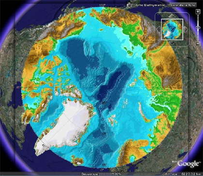
- Polar data in GE: Got GIS that stretches across the poles? Google Earth can’t help you, but you can fake it by applying Gerardo64’s hack: Add your polar projection as a PhotoOverlay, like so:
- Google Maps API Blog‘s Pamela Fox touts the newly improved ability of Google Spreadsheets to geocode, and uses this wizard to turn the result into a Google Map. What all this means is that you can easily do the same and then turn that spreadsheet into KML, using Valery Hronusov’s CONCATENATE trick.
- Oops, I did it again: Iran “accidentally” blocked Google domains on Sunday. Briefly.
- Sailing videos: Virgil Zetterlind over at EarthNC Blog georeferenced 300 YouTube boating videos from around the world and turned the result into KML. Writes Virgil:
This will continue to grow quickly as we process through YouTube and other sources and hopefully start to get link submissions via our forum. Part of the exercise has been in working out a simple user-interface to review and geotag the videos (given that it will be a while, or possibly never, before we can fully rely on up-front geotagging by the authors).
(For PC; For Mac and Linux click on the link through to the YouTube page and watch it there.)