Wirecast + Google Earth = DIY Weather channel

wcinsl.jpg

(I swear there is a Google Earth angle to this post. It’s just at the very end…)

Over at the Swedish Institute we’ve been experimenting with Second Life as a communications medium for engaging in public diplomacy, homing in on those specific functions that virtual worlds excel at, and for which there is no equivalent on the web. (We quickly found that if there is an equivalent on the web, it is likely much more efficient to use the web — there is no point trying to read any sizable amount of text in Second Life, for example.)

The main use we’re looking at is “social viewing” — where an in-world audience can watch live video on a screen at a specific location, simultaneously, giving them the opportunity to discuss the shared experience via chat. This is hard to replicate on the web: You can’t synchronize the viewing of YouTube videos with friends, for example, and even if you do all watch a live video clip — say a Steve Jobs keynote presentation — then there are still no easy ways to open a back-channel for commenting with like-minded strangers; if you use Skype, you only get your buddies. In Second Life, by contrast, everyone who is interested in a presentation just shows up at the appointed time and place. It’s a wonderful example of spatial navigation as an expression of interest — just as we do it in the real world.

With this technology, we plan to show lectures and Swedish short films, teach Swedish lessons, broadcast live Swedish jazz and DJ sessions — all we need is a laptop, a video camera, a microphone, a broadband connection, and Wirecast, a really cool live video editing tool (for Mac and Windows) that lets you create and send a very slick-looking video stream to a streaming server.

The whole system works flawlessly, and it lets us repurpose our content: An open session by the Nordic Council of Ministers, for example, might be broadcast to Second Life, a web page, and mobile phones. Only in Second Life do you get to engage in social viewing, though. In other situations, such as when a the director of a short film attends the Second Life screening to provide running commentary and takes questions from the audience, there is not much point in putting the video stream on the web — all the added value occurs in Second Life.

Where I am going with this on a blog about virtual globes? It soon became evident that this technology can serve very well as a teaching and outreach tool for a range of subjects. Wirecast comes with a helper application, Desktop Presenter, which lets you use the contents of desktop windows as an input to the broadcast, in addition to live video feeds and video, audio and still images from the hard drive. You also don’t need to broadcast live — you can record a performance to disk and publish it later to YouTube, just like a video podcast. I experimented a bit using Google Earth, and made this recording of me showing off some of the possibilities:

(Pardon the wonky first 5 seconds)

A couple of points about the above YouTube clip:

  • All of this was done live, in one go, with me controlling both Wirecast and Google Earth from my laptop. A less stressful setup would be for somebody else to control Wirecast while the talking head just concentrates on talking.
  • It was a very basic experimental set-up:

    wcsetup.jpg

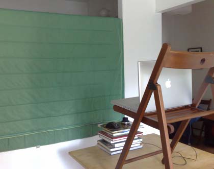
    If I had used a proper colored background for the chroma key, better lighting, a real DV camera and microphone (instead of what’s built into my MacBook Pro) then the result would have been much crisper. Also, Desktop Presenter can send screencasts to Wirecast from other computers on the LAN, so you could have Google Earth running on a second computer, for example, which would share the load. Alternatively, you could have a second monitor off the edge of the background screen, so that would-be meteorologists really can convincingly pretend to stare at what’s behind them.

  • If you’re a schoolteacher, having students make their own broadcasts like this could be a wonderful way to get them interested in meteorology or geography.
  • If you’re doing outreach for anything that involves a geospatial component (science, human rights, environmentalism), this would be a great way to show what you’re about to people who may not be familiar with KML, Google Earth or even computers.

There’s just one catch: cost. Wirecast isn’t cheap — $450, though there is a free demo — and if you want to send live video to more than a few recipients, you’ll need a special webhosting service that can run Quicktime Streaming Server (or the open-source equivalent). But if you’re a school and you want to use Wirecast for class projects, then the price certainly becomes reasonable.

Three quick reviews: The good, the bad and the ugly

  • Good: Rollnzoom is another entry in the crowded place annotation website field, but with a couple of things that set it apart. What’s innovative is that there are several ways in which you can add a placemark — by locating it on a map, by uploading KML, by copying and pasting a placemark from Google Earth or by copying a permalink URL from one of the major mapping services. Places are sorted by date, tag, group, user, latest and popular. The design is light and attractive, though you can only see individual places on maps or Google Earth, not collections of places.

    The other innovation in the placemark collection website field is not something that appeals to me per sé, though perhaps it does to others — it’s the social tools: You can rate others’ reviews of places, get friends, and get points for jumping through various hoops — very much like with social networking sites. (This is not for me as I abhor social networking sites. If anyone ever sees me join Orkut/LinkedIn/Facebook/Friendster/MySpace please shoot me. I mean it. If I get another invite I’ll be forced to launch MyMisanthrope.com — a social networking site with room for only one member.)

  • Bad: NAC Earth is a free Windows-only helper application for Google Earth that lets you navigate to short “universal addresses” (such as “H5Q2 R48Q” for the Eiffel Tower). I’ve never heard of the “Natural Area Coding” (NAC) system before, and I’m not sold on what the advantages might be over old-fashioned coordinates, but it appears to be a kind of tinyURL for places. People who want to geocode to NAC have to pay, though. Is anyone using this? Is there a point to this?
  • Ugly: On a virtual world there need not be any land scarcity — but that’s exactly what Mapisimo is trying to introduce to an instance of Google Maps, letting you “buy” parcels on a first-come first served basis. You get two for free if you register, and you can get more land by referring friends or by paying $2 per small square, of which there are 510 billion all over the planet. On your parcels, you get to write whatever graffitti you want, into a textbox.

    This is a pyramid scheme cum the million-dollar homepage. What a spectacularly bad deal for users. (Laughable press release, with the immortal lines: “Some experts agree that Mapisimo will soon turn into a virtual hangout like Second Life, but by utilising Google Earth this virtual world will be staged in a real world setting.”)

Links: Reverse geocode Google Maps, Geoserver to test KML 3

Links: Vesseltracker, earthquake, Vint Cerf on the geoweb

It feels good to finally be caught up:

  • Ship locations in Google Earth: Vesseltracker not only shows you global ship traffic as KML, but also where and how they are berthed in port. The size and orientation of the ships is drawn as a polygon! There is a free version, plus a real-time pay version. (Via Belgeoblog)
  • Earthquake: Google Earth’s built-in Earthquake layer doesn’t show earthquakes unless you zoom in real close (ergo you know where to look), so use the USGS KML links to find the 7.9 magnitude Peru earthquake.
  • Bad weather: Google Earth Blog puts out a great collection of the best hurricane and weather-related network links. I’d only add Meteogroup’s global live weather forecasts, which includes the most out-of-the-way spots (like the poles).
  • Vint Cerf at GeoWeb 2007: Tobedetermined‘s Alexander van Dijk points to the videos of the speakers at GeoWeb 2007 Conference held a few weeks ago in Vancouver, BC, and especially recommends Vint Cerf’s presentation. Well worth the time investment.
  • AGU submissions: The American Geophysical Union’s fall meeting is coming up in San Francisco in December, and there’ll be a special session on “Using Geobrowsers for Science”. AGU encourages “the participation of developers, teachers, bloggers and others who involved in the evolution of Geobrowsers for use in science, education and beyond” so start submitting those presentations for poster sessions, with a deadline of 6 Sept. All you need to know is right here.
  • New Journal: The academic publication International Journal of Digital Earth will be launched in January 2008 and is looking for submissions. (Via KM Labs)
  • BC does KML: Jason Birch notices that British Columbia’s Electoral Boundaries Commission website is publishing proposed new boundaries as KML.
  • What’s in a name: The Korea Herald reports on another installment of people getting upset about user-generated content not agreeing with their own ideas about what places should be called. In this case, some Panoramio photos are being labelled with non-Korean names.

    The one twist here is that Panoramio’s photo layer is now a default layer, part of the Geographic web, which also includes Wikipedia and Google Earth Community. While you can edit any Wikipedia entry, you can’t really edit somebody else’s Panoramio labels, or at least flag them for perhaps being inaccurate or tendentious. (Flagging as “innapropriate or offensive” doesn’t allow you to explain you think the name is wrong.) So I think the article has something of a point (for a change).

  • More quadtrees: Via the comments, yet another Google quadtree visualization, by Thomas Landspurg.
  • 3D Warehouse to Second Life? Taking 3D objects such as those found in Google’s 3D Warehouse and importing them into Second Life has been a bit of a holy grail but also a technical challenge, and nobody to date has made a sturdy tool for doing this. It wouldn’t surprise me, however, that if anyone can do it it would be Andrew Hudson-Smith’s CASA team. It looks like they’ve almost cracked it.
  • Geoserver up to 1.5.3: Open source Geoserver hits version 1.5.3, adding much-improved KML support, and introducing support for GeoRSS.
  • ESRI ArcGIS Explorer reaches build 410: James Fee has the links and commentary.
  • Virtual Earth gets imagery update: Lots of new bird’s eye views in the US and Europe. Here’s the list.
  • Big 2K: A favorite mapping blog, The Map Room, hits a blogging milestone. Congrats!

Flickr to Google Earth: The August update

The pictures from last weekend’s little Alpine trek have now been geotagged and posted to Flickr, providing a good opportunity to test the latest methods for getting these images onto Google Earth.

Although my camera was the Nokia N95, I didn’t use its built-in GPS receiver to georeference the photos as I took them (which you can, using Shozu). There were numerous reasons: The battery just can’t handle constant GPS tracking, I didn’t want to wait a minute or so to first get a GPS fix every time I took photo, and Shozu only geotags the photos for Flickr, not to the EXIF data (Nokia offers no OEM solution). Instead, I relied on my Garmin GPS receiver (which takes AA batteries), logging my route in order to later correlate times with HoudahGeo or GPSPhotoLinker (both for Mac), adding EXIF coordinate metadata thus.

My plan went awry when my Garmin was stolen out of my rucksack in transit (!) but the route was still fresh in my mind, and with Google’s Swiss data being so accurate, I could easily retrace my steps. I therefore made good use of Geotagger (for Mac, site currently down), which georeferences photos dropped onto it with the coordinates of the current view in Google Earth.

Then it was time to import the photos into Aperture (for Mac) and upload them to Flickr. (Note: With Aperture you can’t do round-trip external editing for EXIF tags such as coordinates (dumb), so you have to georeference them before you import.) After some editing in Aperture I used FlickrExport to get them to Flickr. Here is the set. And here’s what they look like on Flickr’s Map.

How to turn them into KML, so they can be viewed on top of Google’s fantastic Swiss imagery? I compared the two best methods: Flickr’s home-grown method, added last week by Dan Catt, and Steeev’s Yahoo Pipe, which uses the Flickr API and which has been improved since I last used it in May.

Here is the KML by Flickr, and here is the KML by Steeev’s pipe.

How did I fare? Both methods have one significant limitation in that you cannot filter by set when exporting to KML, even though you can filter by tag, user and group. The hack, then, is to assign a unique tag to all members of a set, and this works, but it is a bit, well, hacky.

I don’t think I’m alone in predominantly using sets as a way of organizing my photos. iPhoto ’08 (for Mac) just introduced “events”, which are very similar concept. It is simply that case that I tend to take photos in batches, for example when on a trip, and then upload them in one go, rather than have them trickle onto Flickr. The set for my trek, for example, contains 37 geotagged images.

This leads to one disadvantage for Flickr’s built-in KML generator: It only returns the last 20 georeferenced images for a given tag or user. In my case, it only returns about half the images I took on the trip. The others fall off the end of the feed.

This is not a problem for the Yahoo pipe. By default it returns the most recent 100 georeferenced photos, but if you need more you can just clone the pipe and increase that limit.

Steeev’s pipe has another clever feature: It takes a photograph’s time stamp and adds it into the KML, so that you can time-browse the photos in Google Earth. It will even let you add a bounding box to the filter, so that only photos within a certain region are returned — useful if you’re trying to find georeferenced photos from Paris, Texas, for example:-)

Flickr’s built-in generator easily has the best presentation, with mini photo icons that lead to well-designed popups:

popfl.jpg

The Yahoo pipe looks like this, by contrast:

poppi.jpg

Flickr’s built-in KML generator also looks neater in the sidebar.

Finally, the built-in generator automatically returns a network link to the file, so that it automatically updates as new photos are added. With the pipe, you need to take that extra step of building the network link yourself.

In sum, I’m wishing for a hybrid of these two solutions: The presentation and ease of the Flickr feed with the features of the pipe. In the end, I sent the pipe’s output to friends, because it had to contain 37 geotagged photos. For everyday feed-like geospatial monitoring of photos, Flickr’s solution is the easiest, though the lack of a time stamp diminishes its usefulness to geekier users.

What else can I wish for? I like the ease of FlickrExporter, which exists for both iPhoto and Aperture, and I wish there was something similar for Panoramio, as I think a subset of these photos would certainly fit there. It would be in Google’s interests to lure photographers into submitting properly tagged photos to Panoramio.

One more thing: Google’s Swiss DEM is very very good:

geglac.jpg

1124691302_0e3d9b0bd2_b.jpg

But then we knew that already:-)

Links: GUIs, Flickr hearts KML, Yahoo Pipes does JSON

Playing catchup after a wonderful Alpine interlude. Here’s a first batch. More after a night on Stockholm town (possibly with slightly worse spelling:-).

  • Future GUI-fest: Andrew Hudson-Smith collects a smorgasbord of cool 3D GUIs potentially useful for GIS work. Here’s one that’s 2D but wonderful in a completely different way: Pico, “an interactive tabletop surface that can track the positon of specially marked pucks”, with an array of magnets that can also steer the pucks, making GIS optimisation problems a cinch. Very tactile, and very cool to watch (Via StumbleUpon. Thanks Giasen!)
  • Yahoo embraces KML: Flickr’s Dan Catt adds GeoRSS and KML links to georeferenced photos, grouped by user, group and tag. More on this soon (wherein I use Dan’s update as an excuse to foist my holiday snaps on my unsuspecting blog readership.)
  • Yahoo Pipes goes RESTful (almost): Yahoo Pipes gets an update, with new tools that have potential for geospatial mashups. Writes Yahoo’s Daniel Raffel:
    1. Today Pipes added a Web Service module that allows developers who can write their own web service with the capability of extending Pipes functionality beyond what we offer.

      This module provides developers with a way to start writing their own modules for Pipes!

      There’s a post about it here containing some more details.

      And an example using it here.

      [“This module POSTs the items in a pipe in JSON format to an external web service. This allows developers to extend the Pipes functionality to do whatever they need. The original items are replaced by the web services JSON or RSS response.”]

    2. We also added a new module called Yahoo! Shortcuts that can do entity detection. (Note: we also updated the existing Location Extractor module to use the Y! Shortcuts API too!)

      The Y! Shortcuts module can analyze the input string for popular entities (for example: person, place, concept, organization, etc). If any entities are discovered additional information about each entity is returned (an example of the data returned could include geodata if the entity detected is a place).

      There’s a post about these, and some other updates, here

      And an example using the Y! Shortcuts module here.

    So, use the entity detector to find placenames, then use the web service module to get coordinates for it, for example, or turn RSS into GeoRSS. The main limitation of entity detectors is that they can’t detect Turkey from turkey (when at the start of a sentence) or tell one Springfield from another just from the context.

  • NASA World Wind is hiring: They’re looking for a software engineer who is “deeply experienced in Java and OpenGL.” (Via the Earth is Square)
  • Sydney loses it? Mainstream Australian media (i.e. the Sydney Morning Herald) entertains a conspiracy theory about why the most recent imagery update saw parts of Sydney lose resolution. Was it because there is an Asia-Pacific Economic Cooperation (APEC) summit coming up in September, and Google’s been told to censor? Google says No:

    “This has nothing whatsoever to do with APEC,” Google Australian spokesman Rob Shilikin told Fairfax. “We’re re-sourcing our imagery for parts of Sydney as a result of a commercial issue with one of our suppliers, so some of the highest-res images have been temporarily replaced.”

    Sometimes a coincidence is just a coincidence.

  • New blog GeoChalkboard is producing some solid tutorials on Google Earth that go beyond the introductory level.

AFK: Alpine trekking this weekend

In a few hours I will step away from my computer and head to the Swiss Alps, where I will continue to be afk for a period of no less than 72 hours while also incidentally trekking over some mountains with friends. I tried to remember when I last was away from my computer for three days straight, and came up blank, but then again I can’t remember what life was like before the internet. At all.

I have no idea where we’re headed — but we will be aiming for some of those 1,300 Alpine huts dotted around the alps.

I will have my Nokia N95 with me during my trek, and in order to not completely sever my links to Ogle Earth I will be updating my position regularly using Cristian Streng’s Gmap-Track (batteries permitting). As luck would have it, Cristian’s been developing an embeddable version of the location map. It’s real simple to use, and the code looks like this:

<iframe style=”border:0;padding:0;margin:0 0 10px 0;float:left;” scrolling=no src=”http://www.gmap-track.com/user.php?user=ogleearth&output=embed&zoom=15&mt=s” width=”468″ height=”400″></iframe>

That’ll make a great little widget for the right-hand column of this blog if I make it back. If I don’t, please send reinforcements to the precise location marked on the map above:-)